 Leigh 1830 map

|

|
|
|
item:- JandMN (1_5) image:- © see bottom of page |
click to enlarge |
|
|
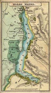
Map, Ulles Water, scale about 1.5 miles to 1 inch,
engraved by Josiah Neele, 352 Strand, published by Leigh and
Son, 421 Strand, London, about 1830.
Bound into Leigh's Guide to the Lakes and Mountains of Cumberland, Westmorland and Lancashire, by M A Leigh, 3rd edn published by Leigh and Son, 421 Strand, London, 1835. |
||

|
Leigh 1830 map | |
| map feature:- | plain cartouche & up is N & scale line & rivers & relief & hill hachuring & woods & parks & county & settlements & roads | |
| inscription:- |
printed title cartouche, top centre
ULLES WATER. |
|
| inscription:- |
printed bottom right
Josiah Neele sc 353 Strand |
|
| scale line:- | 2 miles = 38.5 mm | |
| scale:- | 1 to 84000 ? (1 to 83602 from scale line) | |
| wxh, map:- | 89x154mm | |