 Grose 1772-87

|

|
|
|
item:- Dove Cottage : 2007.38.90 image:- © see bottom of page |
click to enlarge |
|
|
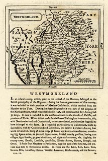
Map, uncoloured engraving, Westmorland, scale about 8
miles to 1 inch, by John Seller, 1694, published , published
by Samuel Hooper, 212 High Holborn, London, 1787.
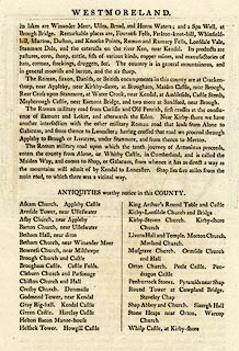
Included in The Antiquities of England and Wales, by Francis Grose. The descriptive text with the map, and on the reverse, describes the county and lists antiquities worthy of notice. |
||

|
Seller 1694 | |
| source type:- | Grose 1772-87 (edn 1787) | |
| map feature:- | plain cartouche & labelled borders & up is N & scale line & sea plain & coast shaded & rivers & lakes & relief & hillocks & county & settlements & roads | |
| inscription:- |
printed title cartouche, upper left
WESTMORLAND |
|
| inscription:- |
printed heading of descriptive text, below map
WESTMORELAND |
|
| scale line:- | 10 miles = 30.7 mm | |
| scale:- | 1 to 520000 ? (1 to 524216 from scale line) | |
| wxh, sheet:- | 22x33.5cm | |
| wxh, plate:- | 144x121mm | |
| wxh, map:- | 141x119mm | |
|
||
|
|
notes | |