 Walker 1837

|

|
|
|
item:- JandMN (126) image:- © see bottom of page |
click to enlarge |
|
|
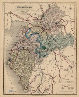
Map, Cumberland, scale about 5 miles to 1 inch, by J and
C Walker, about 1837, published by Longman, Rees, Orme,
Brown, Etc, Paternoster Row, London, edn about 1860s.
|
||

|
Walker 1837 | |
| map feature:- | plain cartouche & up is N & scale line & lat and long scales & sea plain & coast shaded & rivers & relief & hill hachuring & woods & forests & parks & county & electoral data & wards (hundreds) & settlements & roads & canals & railways | |
| inscription:- |
printed plain cartouche, upper left
CUMBERLAND / BY J. & C. WALKER |
|
| scale line:- | 16+1 miles = 89.5 mm | |
| scale:- | 1 to 310000 ? (1 to 305685 from scale line) | |
| wxh, sheet:- | 36.5x45cm | |
| wxh, map:- | 314x394mm | |