 Paterson 1785

|

|
|
|
item:- private collection (19_101) image:- © see bottom of page |
click to enlarge |
|
|
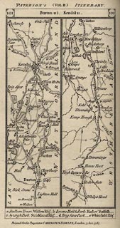
Strip map, part of London to Carlisle by Coventry and
Warrington, scale about 3 miles to 1 inch, by Captain Daniel
Paterson, published by Carington Bowles, 69 St Paul's
Churchyard, London, 1785.
Plate 101/102 in Paterson's British Itinerary, vol.2, by Captain Daniel Paterson, published by Carington Bowles, London, 1785. From before Burton, then Kendal, to beyond Shap, Westmorland. |
||

|
Paterson 1785 | |
| map feature:- | north point & up is destination & rivers & lakes & county & settlements & roads & road distances & distances from London | |
| inscription:- | PATERSON'S (VOL.II.) ITINERARY.: | |
| inscription:- |
printed cartouche at top
101 / Burton 11 1/2, Kendal 11./ 102 |
|
| inscription:- |
printed bottom
Printed for the Proprietor CARINGTON BOWLES, London, 3 Jan. 1785. |
|
| wxh, sheet:- | 11x18.5cm | |
| wxh, map:- | 86x161mm | |
| scale:- | 1 to 190000 ? (guess) | |
|
|
notes | |