 Fisher 1845

|

|
|
|
item:- JandMN (125) image:- © see bottom of page |
click to enlarge |
|
|
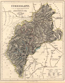
Map, hand coloured engraving, Cumberland, scale about 5.5
miles to 1 inch, published by Fisher, Son and Co, Caxton
Press, Angel Street, St Martin's le Grand, London, about
1845.
Published in Fisher's County Atlas of England and Wales, in parts from 1842 to 1845; there is an associated page of text from the atlas. |
||

|
Fisher 1845 | |
| map feature:- | up is N & scale line & lat and long scales & sea plain & coast line & rivers & lakes & relief & hill hachuring & county & electoral data & settlements & roads & canals | |
| inscription:- |
printed upper left
CUMBERLAND |
|
| inscription:- |
printed bottom
FISHER, SON & CO. LONDON & PARIS. |
|
| scale line:- | 15+1 miles = 71.9 mm | |
| scale:- | 1 to 360000 ? (1 to 358129 from scale line) | |
| wxh, sheet:- | 31x37.5cm | |
| wxh, map:- | 271x340mm | |