 Blome 1673

|

|
|
|
item:- Dove Cottage : Lowther.38 image:- © see bottom of page |
click to enlarge |
|
|
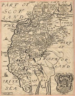
Map, uncoloured engraving, Generall Mapp of the Countie
of Cumberland, scale about 4 miles to 1 inch, by Richard
Blome, 1672, probably engraved by Richard Palmer, published,
London, 1673.
The map has a dedication to and the coat of arms of Charles Howard, Earl of Carlisle. Published in 'Britannia: or, A Geographical Description of the Kingdoms of England, Scotland, and Ireland, ...', 1673. The map is trimmed tight and mounted in the Lowther scrapbook, vol.3; after the title page. |
||

|
Blome 1673 | |
| map feature:- | labelled borders & drape cartouche & up is N & scale line & sea plain & coast shaded & rivers & lakes & relief & hillocks & parks & county & settlements | |
| inscription:- |
printed title cartouche, upper right
A Generall Mapp of the Countie of / CUMBERLAND / Described by Ric. Blome, / By his Matys. Especiall / Command / London Printed for / Richard Blome / 1672 |
|
| inscription:- |
printed cartouche, lower right
To the Rt. Honble. Charles Howard / Earle of Carlisle, Vist. Howard of Morpeth / in Northumberland, Ld Dacres of Gitsland / Ld Leiutenant of ye Countyes of Cumberland / & Westmoreland, & one of ye Ld of his Mait[ ] most / Honourable privy / Counsell [vca] / This Mapp id Humbly dedicated by / Ric Blome coat of arms, gules on a bend between six cross crosslets fitchee argent on an escutcheon thereon a demi-lion rampant pierced through the mouth with an arrow within a double tressure flory counterflory and a difference |
|
| scale line:- | 5 miles = 31.2 mm | |
| wxh, sheet:- | 25x32cm | |
| wxh, map:- | 250x317mm | |
| scale:- | 1 to 260000 ? (1 to 257908 from scale line wrongly assuming a statute mile) | |
|
from:- Scrapbook, 4 volumes, History of Westmorland and Cumberland Illustrated, of descriptive texts, maps, and prints of views and coats of arms, for Westmorland and Cumberland, assembled by a member of the Lowther Family, late 18th early 19th century. The volumes are quarter bound, with marbled paper on the covers; each has a bookplate inside the front cover. The pages cut from various sources are nicely mounted, two sided pieces set neatly in a window in the scrapbook page. The main content is the whole of the two volumes of The History and Antiquities of the Counties of Westmorland and Cumberland, by Joseph Nicolson and Richard Burn, published London, 1777. Nicolson and Burn volume 1 is in scrapbook volumes 1 and 2, volume 2 in scrapbook volumes 3 and 4. Maps and prints are interspersed to make an illustrated version of the history. Some of the sources of maps and prints have been recognised:- Maps - coast of Cumberland etc by Andrew Dury, 1764; Westmorland and Cumberland by Richard Blome, 1673; sheets from Britannia Depicta, Emanuel Bowen, 1720; Cumberland by John Speed, Henry Overton edn 1695; Cumberland by John Cary 1787. Prints from the Set of prints, 20 engravings, Views of the Lakes etc in Cumberland and Westmorland, drawn by Joseph Farington, published by William Byrne, London, 1789. Note that plate numbers vary from edition to edition of this set. Prints from the Antiquities of Great Britain, drawings by Thomas Hearne, engraved by William Byrne, published by Hearne and Byrne, London, 1786-1807. Prints from Britannia Illustrata, drawings by Leonard Knyff, engraved by John Kip, published London, 1707-1740. Print from A Tour in England and Scotland, by Thomas Newte, published by G G J and J Robinson, Paternoster Row, London, 1788.. Some of the coat of arms are cut from A Display of Heraldrie by John Guillim late Pursuivant at Armes, published London, about 1610-11 to 1755. Coats of arms probably from The Baronetage of England, by Edward Kimber and Richard Johnson, published London? 1771. Pages from The Antiquarian Repertory, by Francis Grose, Thomas Astle, et al, published London, 1775-1809. Text from the Baronetage of England by Collins? Scraps cut from an unidentified gazetteer. At the end is the title page and pp.7-51 from A General View of the Agriculture of the County of Cumberland, by John Bailey and George Culley, published by C Macrae, London, 1794. Individual maps and prints are documented separately; with a note of their position in the scrapbooks. inscription:- : embossed: label on spine: (tatty remains): HI[ ] / [ ]/WEST[ ]M[ ] / [ ] / CUM[ ]M[ ] / ILLUS[ ]T[E ] inscription:- : printed & embossed: bookplate: gold on grey; crest, 6 annulets from the coat of arms, flowers, thistles: LOWTHER |
||