 Teesdale 1830

|

|
|
|
item:- JandMN (87) image:- © see bottom of page |
click to enlarge |
|
|
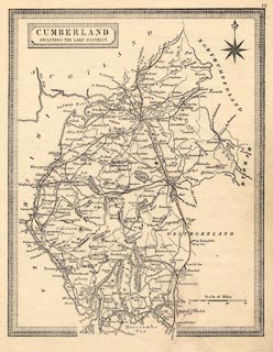
Map, uncoloured lithograph made from an engraving,
Cumberland including the Lake District, scale about 11.5
miles to 1 inch, by Teesdale 1830, lithographed and
published by John Heywood, Manchester, 1868.
Plate 19. |
||

|
Teesdale 1830 | |
| map feature:- | plain cartouche & piano key border & compass rose & up is N & scale line & sea plain & coast form lines & rivers & lakes & relief & hill hachuring & parks & county & settlements & roads & railways | |
| inscription:- |
printed title cartouche, upper left
CUMBERLAND / INCLUDING THE LAKE DISTRICT. |
|
| scale line:- | 15 miles = 33.0 mm | |
| scale:- | 1 to 730000 ? (1 to 731520 from scale line) | |
| wxh, sheet:- | 17.5x23cm | |
| wxh, map:- | 150x192mm | |