 Dugdale 1835

|

|
|
|
item:- private collection (47) image:- © see bottom of page |
click to enlarge |
|
|
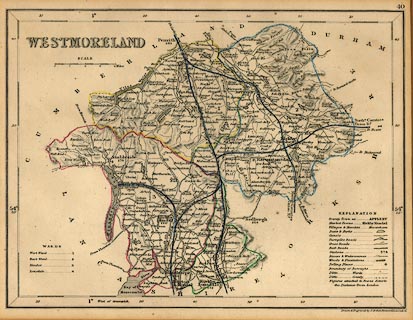
Map, hand coloured engraving, Westmoreland ie
Westmorland, scale about 5.5 miles to 1 inch, by J Archer,
Pentonville, London, about 1835, later edition with
railways.
|
||

|
Dugdale 1835 | |
| map feature:- | table of symbols & up is N & scale line & lat and long scales & coast shaded & rivers & lakes & relief & hill hachuring & forests & parks & county & wards (hundreds) & table of wards (hundreds) & settlements & roads & railways & canals | |
| inscription:- |
printed upper left
WESTMORELAND |
|
| inscription:- |
printed bottom right
Drawn & Engraved by J. Archer Pentonville London. |
|
| scale line:- | 8 miles = 35.8 mm (approx) | |
| scale:- | 1 to 360000 ? (1 to 359630 from scale line) | |
| wxh, map:- | 236x178mm (approx) | |