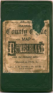
 Bacon c1907

|

|
|
|
item:- private collection (40) image:- © see bottom of page |
click to enlarge |
|
|
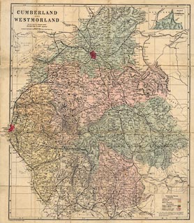
Railway map and political map, colour lithograph,
Cumberland and Westmorland, scale about 3.5 miles to 1 inch,
by G W Bacon and Co, 127 Strand, London, about 1907.
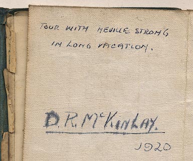
Includes part of Lancashire north of the sands. The map is marked with the route of a tour, presumably that indicated by the inscription on the back of the map, made by D R McKinlay and Neville Strong, in their university long vacation, 1920. |
||

|
Bacon c1907 | |
| map feature:- | mounted & folded (6x4) & card cover & table of symbols & up is N & scale line & lat and long scales & index grid & sea plain & coast line & rivers & lakes & relief & hill hachuring & woods & forests & parks & county & electoral data & settlements & roads & railways & canals | |
| inscription:- |
printed upper left
CUMBERLAND / AND / WESTMORLAND / REDUCED FROM THE ORDNANCE SURVEY / Divided into 5 mile squares |
|
| inscription:- |
printed bottom left
G. W. Bacon & Co. 127 Strand, London. |
|
| inscription:- |
ms reverse
TOUR WITH NEVILLE STRONG / IN LONG VACATION. / D. R. McKINLAY. / 1920 |
|
| scale line:- | 10 miles = 75.0 mm | |
| scale:- | 1 to 210000 ? (1 to 214579 from scale line) | |
| wxh, sheet:- | 48x55.5cm | |
| wxh, map:- | 443x527mm | |
| wxh, folded:- | 9x16.5cm | |
| wxh, cover:- | 10x17cm | |
|
||
|
||