 Owen-Jones 1885

|

|
|
|
item:- JandMN (80) image:- © see bottom of page |
click to enlarge |
|
|
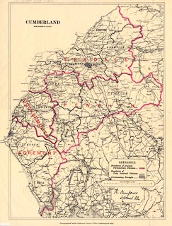
Map, colour lithograph, Cumberland, New Divisions of
County, scale about 4 miles to 1 inch, by LtCol Robert
Owen-Jones, printed by the Ordnance Survey, Southampton,
Hampshire, 1885.
The map shows the proposed new parliamentary divisions, petty session divisions and parliamentary boroughs. |
||

|
Owen-Jones 1885 | |
| map feature:- | table of symbols & up is N & scale line & sea plain & coast line & rivers & lakes & county & wards (hundreds) & settlements & roads & railways & canals & electoral data | |
| inscription:- |
printed top
CUMBERLAND / NEW DIVISIONS OF COUNTY |
|
| inscription:- |
printed cartouche lower right
R. OwenJones / LtColonel R.E ms signature |
|
| inscription:- |
printed bottom
Zincographed at the Ordnance Survey Office, Southampton, 1885. |
|
| scale line:- | 12+4 miles = 103.6 mm | |
| scale:- | 1 to 250000 ? (1 to 248547 from scale line) | |
| wxh, sheet:- | 41x50.5cm | |
| wxh, map:- | 342x475mm | |