 Lewis 1831

|

|
|
|
item:- JandMN (85) image:- © see bottom of page |
click to enlarge |
|
|
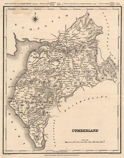
Map, uncoloured engraving, Cumberland, scale about 6.5
miles to 1 inch, drawn by R Creighton, engraved by T
Starling, Wilmington Square, published by Samuel Lewis and
Co, London, 1831.
Published in A Topographical Dictionary of England by S. Lewis & Co., 87, Aldersgate-Street, 1831. |
||

|
Lewis 1831 | |
| map feature:- | compass rose & up is N & scale line & lat and long scales & coast form lines & rivers & lakes & relief & hill hachuring & county & settlements & roads & canals | |
| inscription:- |
printed lower right
CUMBERLAND |
|
| inscription:- |
printed bottom left, centre, right
Drawn by R. Creighton / DRAWN AND ENGRAVED FOR LEWIS' TOPOGRAPHICAL DICTIONARY. / T. Starling sculp Wilmingon Square London |
|
| scale line:- | 20 miles = 77.2 mm | |
| wxh, sheet:- | 31x37.5cm | |
| wxh, plate:- | 252x317mm | |
| wxh, map:- | 235x294mm | |
| scale:- | 1 to 420000 ? (1 to 416928 from scale line) | |