 Horsley 1732

|

|
|
|
item:- JandMN (429) image:- © see bottom of page |
click to enlarge |
|
|
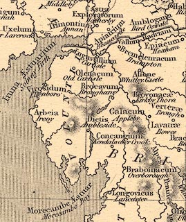
Map, uncoloured engraving, Britannia Antiqua, roman
Britain, scale about 50 miles to 1 inch, by John Horsley,
perhaps 1732, edition published about 1869?
IDENTIFICATION UNCERTAIN |
||

|
Horsley 1732 | |
| map feature:- | plain cartouche & up is N & scale line & scale lines & lat and long scales (trapezoid) & lat and long grid & sea shaded & coast line & rivers & relief & hill hachuring & tribal areas & settlements | |
| inscription:- |
printed title cartouche, upper right
BRITANNIA ANTIQUA, / ADCURANTE / JOHNANNE HORSLEY. |
|
| scale line:- | 60 miles = 30.8 mm | |
| scale:- | 1 to 3100000 ? (1 to 3135086 from scale line) | |
| wxh, map:- | 185x234mm | |
|
||