 Hall 1833

|

|
|
|
item:- JandMN (47_3) image:- © see bottom of page |
click to enlarge |
|
|
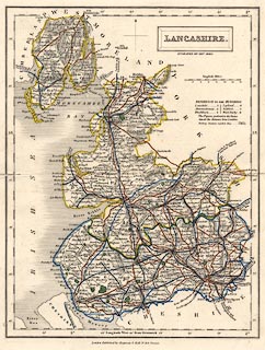
Map, hand coloured engraving, Lancashire, scale about 8.5
miles to 1 inch, by Sidney Hall, published by Chapman and
Hall, 186 Strand, London, about 1860s.
The map, first published 1833, is probably from the Travelling County Atlas or the New County Atlas by Sidney Hall, as engraved uptodate for the 1840s but with manuscript additions, coloured railways to the 1860s. |
||

|
Hall 1833 | |
| map feature:- | plain cartouche & north point & scale line & lat and long scales & sea plain & coast shaded & rivers & lakes & relief & hill hachuring & parks & county & wards (hundreds) & table of wards (hundreds) & settlements & roads & railways & canals | |
| inscription:- |
printed title cartouche, upper right
LANCASHIRE. |
|
| inscription:- |
printed under title cartouche, upper left
ENGRAVED BY SIDY. HALL. |
|
| scale line:- | 14 miles = 41.4 mm | |
| scale:- | 1 to 540000 ? (1 to 544223 from scale line) | |
| wxh, sheet:- | 28x21cm | |
| wxh, folded (in atlas):- | 14x21cm | |
| wxh, map:- | 188x246mm | |