 Hall 1820

|

|
|
|
item:- JandMN (91) image:- © see bottom of page |
click to enlarge |
|
|
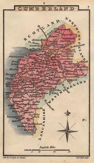
Map, hand coloured engraving, Cumberland, scale about 21
miles to 1 inch, engraved by Sidney Hall, published by S
Leigh, 18 Strand, London, 1820-31.
Published as plate 7 in in Leigh's New Atlas. |
||

|
Hall 1820 | |
| map feature:- | plain cartouche & compass rose & up is N & scale line & coast shaded & coast tinted & rivers & lakes & parks & county & settlements & roads | |
| inscription:- |
printed title cartouche, upper centre
CUMBERLAND |
|
| inscription:- |
printed bottom left and right
Pub. by S. Leigh, 18, Strand. / Sidy. Hall sculpt. |
|
| scale line:- | 30 miles = 36.9 mm | |
| scale:- | 1 to 1300000 ? (1 to 1308410 from scale line) | |
| wxh, map:- | 71x123mm | |