 Garnett 1850s-60s D

|

|
|
|
item:- private collection (21) image:- © see bottom of page |
click to enlarge |
|
|
Map, colour printed, New Section Maps of the Lakes, scale
about 2 miles to 1 inch, by John Bartholomew, Edinburgh,
published by John Garnett, Windermere, Westmorland,
1850s-60s?
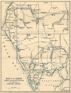
The card folder has an index map, scale about 6 miles to 1 inch, and 4 sections of maps for the Lakes. This copy of the set of maps is wrongly assembled; it has maps 1, 2, 2, and 4 - map 3 missing. |
||

|
Garnett 1850s-60s D | |
| map feature:- | colour printed & sectioned for folding & folded & card cover & index map & up is N & scale line & rivers & lakes & relief & hill hachuring & woods & forests & parks & county & settlements & roads & railways | |
| inscription:- |
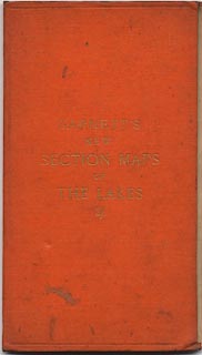
printed cover
GARNETT'S / NEW / SECTION MAPS / OF / THE LAKES / 2/- gold on orange |
|
| inscription:- |
printed index map, lower left
MAP OF THE LAKES / SHOWING THE RELATIVE POSITION / OF THE SUBJOINED / TRAVELLING SECTIONS. |
|
| inscription:- |
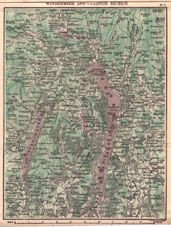
printed top of 1
WINDERMERE AND CONISTON SECTION No.1 |
|
| inscription:- |
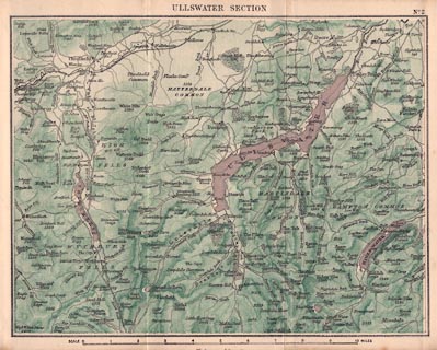
printed top of 2
ULLSWATER SECTION No.2 |
|
| inscription:- |
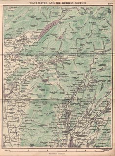
printed top of 4
WAST WATER AND THE DUDDON SECTION No.4 |
|
| inscription:- |
printed bottom of 1
J. Bartholomew. Edinr. |
|
| inscription:- |
printed bottom of 2 and 4
Windermere; J. Garnett |
|
| scale line (1):- | 10 miles = 126.9 mm | |
| scale line (2):- | 10 miles = 126.6 mm | |
| scale line (1):- | 10 miles = 127.0 mm | |
| scale line (index map):- | 6 miles = 24.4 mm | |
| scale:- | 1 to 130000 ? (1 to 127321 from scale line, averaged) | |
| scale, index map:- | 1 to 400000 ? (1 to 395740 from scale line, averaged) | |
| wxh, folder:- | 9.5x17cm | |
| wxh, index map:- | 145x189mm | |
| wxh, map 1:- | 148x192mm | |
| wxh, map 2:- | 192x147mm | |
| wxh, map 4:- | 148x192mm | |
|
||
|
||
|
||
|
||
|
|
notes | |