 Garnett 1850s-60s D

|

|
|

|
back to object record | |
| MAP FEATURES | ||
|
The map is colour printed, by lithography? black and green
on white. Black is used for most map features and all
labelling. The underlying green layer has dotted areas,
engraved by roulette? and hill hachuring. The dotted
background stops where there is a lake to be shown. A close
look shows up problems in registration of the two printings,
particularly noticeable by lake shores. The resulting maps
are slightly gloomy to the eye, and the hachuring, as usual,
obscures map features and labelling without compensating by
the reward of good relief information.
|
||
|
NB: the set of maps in the folder is incomplete, and always
has been. The ?printer has bound up sheets 1, 2, 2, and 4 in
the card folder, missing sheet 3. Remember this when reading
the notes below.
|
||
|
|
||
|
title
map maker publisher |
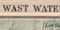
Each map section has a title printed at the top:- WINDERMERE AND CONISTON SECTION No.1 ULLSWATER SECTION No.2 WAST WATER AND THE DUDDON SECTION No.4 Printed at the bottom of some sheets are:- J. Bartholomew. Edinr. Windermere; J. Garnett The card folder has an orange cover with printed and embossed title in gold:- GARNETT'S NEW SECTION MAPS OF THE LAKES / 2/- |
|
|
|
||
|
orientation
up is N |
The maps have no indicator of orientation. The maps are
printed with North at the top of each sheet; they are bound
into the folder in different ways.
|
|
|
|
||
|
scale line
scale |
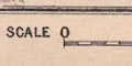
Each section map has a scale line printed at the bottom:- SCALE / MILES divided and labelled in miles, the first miles divided in furlongs. On average the 10 miles = 126.4 mm giving a scale 1 to 127321 assuming a statute mile. The map scale is about:- 1 to 130000 2 miles to 1 inch |
|
|
|
||
|
rivers
bridges ferries |
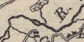
Rivers are drawn by wiggly line tapering upstream, and might be labelled, eg:- R. Duddon Scandale Beck Stock Gill Steers Pool Notice that gill is used for a stream rather than its gully, just as today. River and valley might both be labelled, as at Deepdale, the style of labels being different, river in italic lowercase, the valley in upright italic. The map is a rich source for river names. Waterfalls might be shown by two lines drawn across a stream, and labelled, eg:- 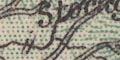
Stockgill Force High Fall [Rydal] Low Fall [Rydal] Bridges are implied where a road crosses and interrupts a stream, be wary of taking this as fact. 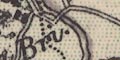
Some bridges are labelled, though it is not clear whether the bridge or the settlement by it is meant, eg:- Newby Bridge Troutbeck Bri. It is more likely the settlement is labelled at:- Bowland Bridge But there might be a bridge and no settlement as at:- New Bridge over the Great SW of Threlkeld; and at:- Ees Br. Windermere Ferry is marked by a dotted line. The pier to the east is obvious; the line is hidden in the grey of the lake, and by the label for the:- Ferry Hotel on the west shore. |
|
|
|
||
|
lakes
islands |
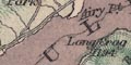
Lakes are drawn in outline, printed dull grey. Many, all? large and small, are labelled (I can't promise to have them all, and anyway, map 3 is missing). map 1:- Allan Tarn Arnsbarrow Tarn Beacon Tarn Blea Tarn / 612 Blelham Tarn Boo Tarn Bortree Tarn Codale Tarn CONISTON WATER Easedale Tarn / 915 Elter Water / 187 ESTHWAITE WATER / 217 GRASMERE LAKE / 203 High Dam [Stott Park] Kentmere Reservoir / 973 Levers Water / 1350 Lindeth Tarn Lit. Langdale Tarn / 340 Loughrigg Tarn Low Tarn Low Water / 1786 Out Dubs Tarn Priest Pot Reservoir [by Borwick Fold] RYDAL LAKE / 181 Stickle tarn / 1540 WINDERMERE map 2:- Angle Tarn Blea Tarn / 1582 [Wythburn Fells] Blea Water / 1584 [by Mardale] Brothers Water / 520 Dock Tarn / 1322 Grisedale Tarn / 1768 HAWES WATER / 694 Hayes Water / 13[ ]3 Keppelcove Tarn / 1825 Red Tarn / 2356 Small Water / 1484 Tewel Tarn THIRLMERE / 533 ULLSWATER / 477 map 4:- Angle Tarn / 1553 Blea Tarn [Eskdale] Blind Tarn Burnmoor Tarn / 832 Devoke Water / 766 Eel Tarn Low Tarn Red Tarn Seathwaite Tarn / 1210 Siney Tarn Sprinkling Tarn WAST WATER / 204 The number is the height, feet, above sea level. Looking for all the lakes demonstrates the density of detail on these maps, and demonstrates how difficult it is to read it - I used a magnifying glass on a slightly enlarged copy! Islands are shown in various lakes, some labelled, some not. On Windermere, for example, are:- 
Belle isle Blake Holme Grass Holme Green Turf I Lady Holme Ramp Holme Rough Holme Silver Holme Thompsons Holme and some unlabelled islets. Some boathouses, piers, etc are noticed on lake shores. |
|
|
|
||
|
relief
hill hachuring spot heights |
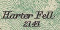
Relief is indicated by hill hachuring, printed in green. Though it is possible to read the hachuring to see ridges and peaks, the map gives no overall impression of the Lake District dome and radiating valleys. Many hills are labelled, some with heights, eg:- Brown Hills Browncove Crags Coldbarrow Fell Froswick / 2359 Il Bell / 2476 Little Hart Crag / 2091 Middle Dodd / 2106 Nab Scar Ulpha Fell / 1336 Some valleys are labelled, eg:- Deepdale Wastdale Wrynose Bottom Some passes are labelled, eg:- Kirkstone Pass Styhead Pass |
|
|
|
||
|
woods
forests trees |
Woodland is indicated by groups of tree and undergrowth
symbols, mostly inclosed. Some of the areas are parks, some
others are labelled as woods, eg:-
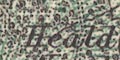
Heald Wood The Wood [N of Windermere] Gt. Tower Plantation Naddle Forest |
|
|
|
||
| parks |
Parks might be drawn in outline, wooded, perhaps labelled
by name or the name of the house, eg:-
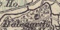
Dalegarth Hall High Stott Park Barron Park but:- Gowbarrow Park has no outline, and may or may not include various bits of woodland. |
|
|
|
||
| county |

County boundaries are a fine dotted line, which may or may nor be continued alongside a boundary feature like a river or lake shore. The boundaries are not easy to follow. The county areas are not labelled. |
|
|
|
||
| settlements |
Settlements are drawn by blocks or groups of blocks,
perhaps a cross for a church, differentiated by style of
labelling. The differentiation may not match our present
ideas of the relative importance of places.
|
|
| towns |
group of blocks; labelled in upright block caps, eg:-
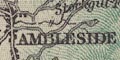
AMBLESIDE HAWKSHEAD GRASMERE BROUGHTON in Furness Not all these are market or borough towns. |
|
| villages |
blocks; labelled in upright lowercase text, eg:-
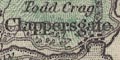
Clappersgate Torver Patterdale Pooley Bridge |
|
| hamlets |
block or blocks; labelled in italic lowercase text,
eg:-
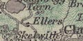
Ellers Low Hartsop Thackthwaite Tirril |
|
|
|
||
| roads |
A network of roads is drawn by double line. There is some differentiation of broader and narrower roads. The lines become dotted for tracks. |
|
|
|
||
| railways |
Railways are drawn by a double line with cross ties. The section maps include a smaller area, and fewer railways, than the index map - for which the railways are described more fully. |
|
|
|
||
| miscellaneous |
I haven't found all the less systematically plotted
features, but the following are a selection.
|
|
|
|
||
|
mines
copper mines |
Marked by blocks on the NE side of Wetherlam are:-
Copper Wks Marked by circles are:- Tilberthwaite Copper Mines Copper Mines [near] Up Church Beck from Coniston, marked by blocks, are:- Paddy End Copper Works Coniston Copper Wks On Plough Fell:- Copper Mine Also:- Seathwaite Copper Mines |
|
|
|
||
|
quarries
slate quarries |
On Holme Fell:-
Penny Rig Slate Quarries and on the S side of Old Man:- Cove Slate Quarries |
|
|
|
||
|
mines
lead mines |
Lead mines are noticed at:-
Woodend Mine (Lead) [NE of Threlkeld] Blencathra Mine (Lead) Greenside Mine (Lead) Greenside Smelting Mill The last two up Glenridding. |
|
|
|
||
| gunpowder works |
Just N of High Nibthwaite is:-
Gun Powder Depot |
|
|
|
||
|
mills
water mills |
On the Grizedale Beck, S of Satterthwaite:-
Force Mills and on the Cunsey Beck by Windermere:- Mill |
|
|
|
||
| inns |
Some inns and hotels are noticed, eg:-
Kirkstone Inn Low Wood Hotel Lake Hotel [by Grasmere] Hotel [Glenridding] |
|
|
|
||
| stones |
Labelled on Wrynose:-
Three Shire Stones |
|
|
|
||
|
antiquities
stone circles |
A circle by Castlerigg is labelled
Druidical Circle N of Boot are Druidical Temples and on Swinside Fell:- Druidical Temple |
|
|
|
||
|
antiquities
earthworks |
Two circles N of High Heathwaite are a:-
British Settlement |
|
|
|
||
|
antiquities
standing stones |
On Swarth Fell, and on Bampton Common are:-
Standing Stones |
|
|
|
||
|
antiquities
roman sites roman roads |
The road through Tirril by Winder hall is labelled:-
High Street Roman Road and the label is repeated where expected towards High Street. |
|
| Index Map Features | ||
|
The card folder includes an index map, scale about 6 miles
to 1 inch. Its particular interest is the evidence it
provides for dating from the railways shown. The index map
includes a larger area than the section maps, and thus shows
more railways.
|
||
|
|
||
| railways |
Railways are drawn by a bold line, perhaps labelled with
the railway name. Stations are taken for granted within
settlements, but elsewhere are marked by a line across the
track, and labelled, eg:-
Seascales Sta. The following railways can be identified:- |
|
| Lancaster and Carlisle Railway |
Opened 1846.
Shown; labelled:- Lancaster & Carlisle Railway |
|
| Kendal and Windermere Railway |
Opened 1845-46.
Shown; labelled:- Kendal & Windermere Railway And see map 1. |
|
| Cockermouth and Workington Railway |
Opened 1847.
Shown; not labelled. |
|
| Furness Railway |
Parts opened 1846-54.
Shown; not labelled. And see map 4. |
|
| Whitehaven and Furness Junction Railway |
Opened 1849-55.
Shown; not labelled. |
|
| Ulverstone and Lancaster Railway |
Authorised 1851. (No spelling mistake).
Shown; labelled:- Lancaster Railway |
|
| Whitehaven, Cleator and Egremont Railway |
Opened 1856-57.
Shown; not labelled. |
|
| Coniston Railway |
Opened 1859-60.
Shown; not labelled. And see map 1. |
|
| Cockermouth, Keswick and Penrith Railway |
Authorised 1861; opened 1864-65.
Shown; not labelled. And see map 2. |
|
|
The following two railways, soon after the last opening
date above, are not shown:-
|
||
| Egremont and Sellafield branch railway |
Authorised 1866; opened 1869.
|
|
| Lakeside branch railway |
Authorised 1866; opened 1869.
|
|
|
The dates of the railways suggest the map was prepared
about 1865.
|
||
| John Garnett | ||
|
A fairly quick search in local directories discovers that
John Garnett is listed as a bookseller, sometimes also
printer, publisher, stationer, chemist, and/or post master,
at Church Street Windermere, in 1858, 1869, 1873, 1884. But
not in 1849, 1885, 1897.
|
||
|
Sources:-
|
||
|
|
||
Lakes Guides menu.