 Cooke 1802

|

|
|
|
item:- Hampshire Museums : FA2000.62.0 image:- © see bottom of page |
click to enlarge |
|
|
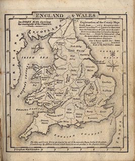
Map, uncoloured engraving, England and Wales, index map
to county maps, perhaps by George Cooke, 1802, bound in
Gray's New Book of Roads, published by Sherwood, Jones and
Co, Paternoster Road, London, 1824.
It is unusual to see the sophistication of numbering from 0. |
||

|
Cooke 1802 | |
| inscription:- |
printed top right
0 |
|
| inscription:- |
printed top
ENGLAND & WALES |
|
| inscription:- |
printed upper left
An INDEX MAP, shewing / the contiguity of the Counties. |
|
| wxh, sheet:- | 12x14.5cm | |
| wxh, map:- | 107x124mm | |