 Bartholomew 1899

|

|
|
|
item:- JandMN (23_9) image:- © see bottom of page |
click to enlarge |
|
|
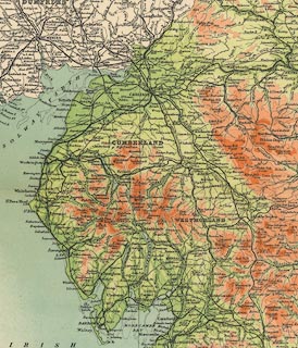
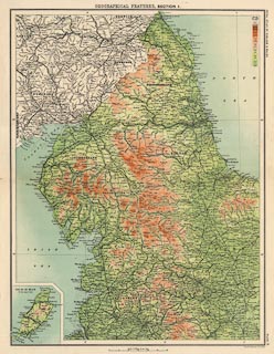
Map, colour lithograph, Orographical Features, section 1,
scale about 10 miles to 1 inch, by John Bartholomew,
Edinburgh, Lothian, 1899-1900.
Plate 9 from the Royal Atlas of England and Wales; shows relief in the north west of England, including Westmorland, Cumberland, and other counties. |
||

|
Bartholomew 1899 | |
| map feature:- | up is N & scale line & lat and long scales & lat and long grid & sea tinted & coast line & rivers & lakes & relief & contours & layer colouring & table of heights & county & settlements & roads & railways & inset map (Isle of Man) | |
| inscription:- |
printed top centre
OROGRAPHICAL FEATURES, SECTION 1. |
|
| inscription:- |
printed right side
ROYAL ATLAS OF ENGLAND & WALES / PLATE 9 |
|
| inscription:- |
printed bottom right
John Bartholomew & Co. Edinr. |
|
| scale line:- | 30 miles = 74.1 mm | |
| scale:- | 1 to 650000 ? (1 to 651556 from scale line) | |
| wxh, sheet:- | 37x47cm | |
| wxh, map:- | 327x429mm | |
|
||