 Bartholomew 1899

|

|
|
|
item:- JandMN (23_20) image:- © see bottom of page |
click to enlarge |
|
|
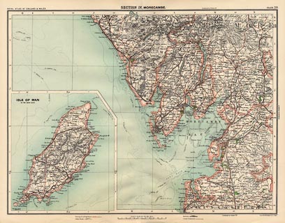
Map, colour lithograph, Morecambe, scale about 4 miles to
1 inch, by John Bartholomew, Edinburgh, Lothian, 1899-1900.
Plate 20 from the Royal Atlas of England and Wales; includes parts of Cumberland, Westmorland, and Lancashire; and an inset map of the Isle of Man. |
||

|
Bartholomew 1899 | |
| map feature:- | up is N & scale line & lat and long scales & lat and long grid & index grid & sea tinted & coast line & rivers & lakes & relief & hill hachuring & parks & county & settlements & roads & railways & inset map | |
| inscription:- |
printed top, left, centre and right
ROYAL ATLAS OF ENGLAND & WALES / SECTION IV. MORECAMBE / PLATE 20 |
|
| inscription:- |
printed bottom right
Johnn Bartholomew & Co. Edinr. |
|
| scale line:- | 12 miles = 74.8 mm | |
| scale:- | 1 to 260000 ? (1 to 258184 scale line) | |
| wxh, sheet:- | 45.5x35.5cm | |
| wxh, map:- | 424x321mm | |