 Laurie and Whittle 1806

|

|
|
|
item:- private collection (18_21) image:- © see bottom of page |
click to enlarge |
|
|
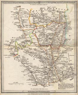
Road map, Continuation of the Roads to Glasgow and
Edinburgh, scale about 10 miles to 1 inch, by Nathaniel
Coltman? 1806, published by Robert H Laurie, 53 Fleet
Street, London, 1834.
Plate 21 in Laurie's New Traveller's Companion, 1834. The main roads shown which are relevant to Cumberland, Westmorland etc, now Cumbria are - from the south through Wetherby, Yorkshire; through Brough and Appleby, Westmorland; then Penrith to Carlisle and on through Longtown, Cumberland; then into Scotland AND parts of the London to Carlisle road through Kendal. |
||

|
Laurie and Whittle 1806 | |
| map feature:- | north point & scale line & up is NW & sea plain & coast line & rivers & county & settlements & roads & distances from London & canals | |
| inscription:- |
printed top border
Continuation of the Roads to Glasgow & Edinburgh, as far as Longtown & Morpeth, 21 with Roads to Scarborough, Whitby, Sunderland, and South & North Shields. |
|
| inscription:- |
printed lower border
ROADS MEASURED FROM HICK'S HALL. |
|
| inscription:- |
printed bottom
London : Published by R. H. LAURIE, No.53, Fleet Street. |
|
| scale line:- | 15+5 miles = 50.0 mm | |
| scale:- | 1 to 650000 ? (1 to 643738 from scale line assuming a statute mile) | |
| wxh, sheet:- | 26.5x32.5cm | |
| wxh, map:- | 252x308mm | |
|
|
notes | |