 Laurie and Whittle 1806

|

|
|

|
back to object record | |
| ROAD BOOK FEATURES | ||
|
|
||
| title |
The road book title page reads:-
LAURIE AND WHITTLE'S NEW TRAVELLER'S COMPANION Exhibiting A COMPLETE AND CORRECT SURVEY Of all the DIRECT and principal CROSS ROADS in ENGLAND, WALES and SCOTLAND, as far North as Edinburgh, and Glasgow: by Nathl: Coltman. 1806 Published 12th. Feby. 1806 by LAURIE & WHITTLE, No.53 Fleet Street, London. |
|
|
|
||
| advertisements |
There is an advertisement:-
THE principal Credit the Author attaches to himself, from the Construction of this Work, is the ease with which the Traveller may find his Way from the Metropolis to any Part of the Kingdom, (as far North only as Edinburgh and Glasgow,) and from one Market Town to another. It must claim a Superiority over any Itinerary, from the Roads being kept so connected, that the Traveller may find his Way to the most distant Part, without the unnumerable references which must unavoidably occur in all Works of that Description:- it likewise has a great Advantage over a Map of England, by the Names of Places reading parallel to the Sight, whereas all the Southern and South-Western Roads in the General map read upside down. The Roads inserted in this Work are those usually travelled, from the Metropolis to every City, Market Town, Manufacturing Town and Seaport in the Kingdom; and particular care has been taken to select those Cross-Roads, from one Place to another, which may be travelled with Safety at any Season of the Year. The Rivers, and the whole of the navigable Canals (for which Acts of Parliament have passed) which intersect the Roads, are inserted to gratify the Curiosity of the Traveller; but, as it is impossible to obtain accurate Knowledge of the intended Course of such as are not yet completed, any Information from Gentlemen Tourists will much oblige the Publishers. |
|
|
|
||
| table of symbols |
The road book has an 'Explanation' which declares:-
Cities [labelled in upright block caps] Market Towns [labelled in upright lowercase text] Villages etc [labelled in lowercase italic] Mail Coach Roads (Direct) [double line, bold light, coloured pink] Cross Mails [double line, dotted, coloured pink] Principal Travelling Roads [bold single line] Other Direct Roads [light single line] Cross Roads [dotted single line] Towns and Places which supply the Traveller with Post Horses and Carriages [marked with an asterisk] |
|
|
|
||
| table of symbols |
An early edition of the road book has an 'Explanation'
which declares:-
Cities [labelled in upright block caps] Market Towns [labelled in upright lowercase text] Villages and Places [labelled in lowercase italic] Mail Coach Roads (Direct) [double line, bold light, coloured pink] Cross Mails [double line, dotted, coloured pink] Principal Travelling Roads [bold single line] Other Direct Roads from LONDON [light single line] Cross Roads [dotted single line] Indifferent Cross Roads [single dotted line, bolder?] An Asterisk attached to those Towns, Villages and Places which supply the Traveller with Pots Horses and Carriages. On this Work are delineated every Town, Village and Place situate on the Direct Roads with the Distances from the respective Standards in London from Actual Surveys. The Measurements on the Cross Roads are from one Market Town to another. The Connection of the Cross and other Roads are kept up throughout the Kingdom by reference Figures and branching Roads affixed to their Extremmities on each adjacent Page. |
|
| MAP FEATURES | ||
|
The notes are strongly biased towards a Lake District
interest, other parts of the maps being ignored.
|
||
|
|
||
|
title
publisher |
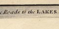
On plate 18, printed in the top border, bottom border, and at the bottom:- Completion of the Roads to the LAKES, with Roads to Whitehaven, ... Workington, Maryport and CARLISLE (by Lancaster) ROADS MEASURED FROM HICK'S HALL. London: Published by R. H. LAURIE, No.53, Fleet Street. On plate 21 printed in the top border, bottom border, and at the bottom:- Continuation of the Roads to Glasgow & Edinburgh, as far as Longtown & Morpeth, 21 with Roads to Scarborough, Whitby, Sunderland, and South & North Shields. ROADS MEASURED FROM HICK'S HALL. London: Published by R. H. LAURIE, No.53, Fleet Street. |
|
|
|
||
|
orientation
north point up is NW |
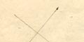
Printed upper left on each plate is a north point; N-S line, E-W cross line, North marked by a spear head. The maps are printed with North West at the top of the sheet. |
|
|
|
||
|
scale line
scale |
Printed lower left of each sheet is a:-
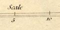
Scale marked and labelled at 5 mile intervals with a left extension marked and labelled in miles. On plate 18 the 15+5 miles = 49.7 mm gives a scale about 647623. The map scale is about:- 1 to 650000 10 miles to 1 inch On plate 21 the 15+5 miles = 50.0 mm gives a scale about 1 to 643738. the map scale is about:- 1 to 650000 10 miles to 1 inch. In each case assuming a statute mile. |
|
|
|
||
|
sea area
sea plain |
The sea area to the east of Cumberland is plain.
|
|
|
|
||
|
coast line
coast tinted lighthouses foreshore sands |
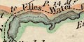
The coast line is emphasised by a blue tint in the offing, and also, incidentally, by the county boundary tint. The coast line in the larger river estuaries has form lines. Various estuary sands are marked by dotting, labelled:- Duddon Sands Leven Sands 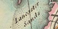
Lancaster Sands the last has a further note:- Lancaster Sands may be crossed when the tide is out. On the south east tip of Walney Island is a tower symbol, labelled:- Light |
|
|
|
||
|
rivers
bridges distances from London |
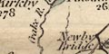
Some rivers are drawn by wiggly line tapering upstream, the lower part might be broader with form lines. The river might be labelled, eg:- Emont R. Loyne River [Lune] R. Waver Bridges are implied where a road crosses and interrupts a stream, but this is not clear where the road is a single line. Some bridges are labelled, eg:- 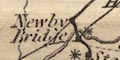
Lowther Bridge / 282 Low Barrow Bridge / 271 3/4 The figures are distances from London. A bridge might be labelled without a river, as at:- Hell Gill Br. |
|
|
|
||
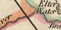
| lakes |
Lakes are drawn in outline with form lines, tinted blue. All are labelled:- Angle Tarn Bassenthwaite water Beacon Tarn Blelham Tarn Broader Water [Brothers Water] Burnmoor Tarn Buttermere Water Coniston Water Crummock Water Derwent W. Devock Lake Easthwait Water Elter Water Ennerdale Water Goats Water Grasmere water Hawes Water Hays Water The Tarn [Kentmere] Levers Tarn Lowes Water Over Water Rydal Water Saithwaite Tarn Skeggles Water Thirles Mere [shown as two parts] Ulles Water Wast Water Winander Meer And a couple of lakes outwith the Lake District. |
|
|
|
||
| county |
County boundaries are a fine dotted line, tinted on the inside of each county; Westmorland green, Cumberland orange, Lancashire red, Yorkshire yellow, Durham red, Northumberland yellow. the tints on the two sheets agree. The county areas are labelled, eg:- WESTMORELAND |
|
|
|
||
|
settlements
distances from London |
Settlements along large and small roads are marked by
dot, differentiated by style of labelling. Most placenames
are accompanied with a figure for the distance from London,
which does not distinguish what route was used.
The explanation in an early edition of the road book declares that:- On this Work are delineated every Town, Village and Place situate on the Direct Roads with the Distances from the respective Standards in London from Actual Surveys. |
|
| cities |
dot; labelled in upright block caps, eg:-
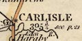
CARLISLE 301 1/2 |
|
| towns |
dot; labelled in upright lowercase text, eg:-
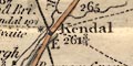
Kendal / 264 1/2 Appleby / 269 3/4 |
|
|
villages
hamlets |
dot; labelled in italic lowercase text, eg:-
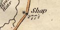
Shap / 277 1/2 Grayrigg / 268 1/4 Pendragon Castle / 262 1/2 |
|
|
Italic lowercase is used generally for a variety of
features.
Some places have an asterisk attached; as explained in the road book introduction:- Towns and Places which supply the Traveller with Post Horses and Carriages [marked with an asterisk] Carlisle has a letter G and Kendal a letter E; these are not understood. |
||
|
|
||
| towns |
Places shown as towns on the two plates are:-
|
|
| Westmorland towns |
Ambleside
Appleby Brough Burton Kendal Kirkby Lonsdale Kirkby Stephen Milnthorpe Orton |
|
| Cumberland towns |
Aldstone Moor
Bootle Brampton CARLISLE Cockermouth Egremont Hesket Newmarket Ireby Keswick Kirk Oswald Longtown Maryport or Ellenfoot Penrith Ravenglass Whitehaven Wigton Workington |
|
| Lancashire towns |
Cartmel
Dalton Hawkshead Ulverston |
|
| Yorkshire towns |
Sedbergh
|
|
|
|
||
|
roads
road distances |
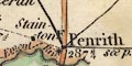
More important places on the map are plotted in their proper position (near enough) and roads are mostly drawn in straight segments by double or single lines. Lesser places are plotted along the roads. The routes are graded as explained in the road book introduction:- Mail Coach Roads (Direct) [double line, bold light, coloured pink] Cross Mails [double line, dotted, coloured pink] Principal Travelling Roads [bold single line] Other Direct Roads [light single line] Cross Roads [dotted single line] In one instance, from Wolsingham, Durham to Brough, Westmorland, the dashed line is labelled:- proposed road The main routes in Westmorland and Cumberland are:- plate 18 from the south through Lancaster, Lancashire; through Burton, Kendal, Shap, Westmorland; then Penrith to Carlisle, Cumberland. Note that the 'Roads to the Lakes' begins on plate 16 - from Hicks Hall, Middlesex to Leicester, continued on plate 17 - to Chorley, Lancashire, and is only relevant to Cumbria from plate 18. plate 21 from the south through Greta Bridge and Bowes, Yorkshire; through Brough and Appleby, Westmorland; then Penrith to Carlisle. from Carlisle through Longtown, Cumberland; then into Scotland branch from Longtown, Cumberland; towards Gretna, Scotland. parts of the London to Carlisle road through Kendal. Some places are accompanied by a connecting label, eg at Penrith:- see p.21. And road destinations might be given. So the road from Penrith has:- to Aldstone p.21. Road distances are given at places, not at regular miles along the roads. Distances are given to the nearest quarter mile from Hicks Hall, London. For example at Shap:- 277 1/2 from London Bridge. Some of the minor routes have their length alongside the road, eg:- Maryport to Wigton 15 3/4 M. Kendal to Sedbergh 10 3/4 H. to C. 17 1/2 Ms. [Abbey Holme to Carlisle] |
|
|
|
||
| canals |
A canal is drawn by a triple line, light bold light. |
|
| Lancaster Canal |
from a junction on the Leeds and Liverpool Canal south of
Chorley ... through Lancaster, Lancashire to Kendal,
Westmorland.
Lancaster Canal |
|
|
|
||
| shipping routes |
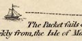
A dashed line is drawn from Whitehaven, ending at a sailing boat after a bend that neatly edges round the label:- The Packet sails every Tuesday to, and returns weekly from, the Isle of Man; dist. 48 Miles. |
|
|
|
||
| miscellaneous | ||
|
|
||
| inns |
An inn might be noticed, eg:-
Lowood Inn / 277 with an asterisk indicating horses are available. |
|
|
|
||
| stones |
Noticed on the county boundary, no special symbol,
are:-
Dunmail Raise Stones / 284 1/4 |
|
Lakes Guides menu.