 Clarke 1787 map

|

|
|
|
item:- private collection (10_5) image:- © see bottom of page |
click to enlarge |
|
|
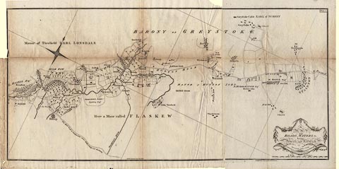
Map, A Map of the Roads, Waters &c between Penrith and
Keswick, scale about 2 ins to 1 mile, by James Clarke,
engraved by S J Neele, 352 Strand, published by James
Clarke, Penrith, Cumberland and in London etc, 1787.
Plate 5 in A Survey of the Lakes of Cumberland, Westmorland, and Lancashire. The map is printed on two sheets of paper which were pasted together but have become unfixed; it is possible to match the folds of the separate pieces and see how they were joined and folded into the book. The map shows the road from about Stainton to beyond Threlkeld. |
||

|
Clarke 1787 map | |
| map feature:- | floral cartouche & north point (decorative, plus an iregular grid of N-S, E-W lines to show orientation?) & up is NW (roughly) & scale line & rivers & woods & county & settlements & roads | |
| inscription:- |
printed title cartouche, lower right
A / MAP / of the / ROADS, WATERS &c. / Between / Penrith and Keswick / Surveyed by James Clarke. / Engraved by S. J. Neele 352 Strand London. |
|
| inscription:- |
printed upper right
Plate 5. |
|
| inscription:- |
printed lower centre
Published Feby. 10, 1787, by James Clarke, Penrith. |
|
| scale line:- | 190+20 chains = 151.1 mm | |
| scale:- | 1 to 28000 ? (1 to 27958 from scale line) | |
| wxh, sheet 1:- | 61.5x46cm | |
| wxh, sheet 2:- | 31x49cm | |
| wxh, folded:- | 22x32cm | |
| wxh, map:- | 867x411mm | |