 Laurie and Whittle 1806

|

|
|
|
item:- private collection (18_18) image:- © see bottom of page |
click to enlarge |
|
|
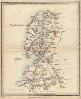
Road map, Completion of the Roads to the Lakes, scale
about 10 miles to 1 inch, by Nathaniel Coltman? 1806,
published by Robert H Laurie, 53 Fleet Street, London, 1834.
Plate 18 in Laurie's New Traveller's Companion, 1834. The main road relevant to Westmorland, Cumberland etc, now Cumbria is - from the south through Lancaster, Lancashire; through Burton, Kendal, Shap, Westmorland; then Penrith to Carlisle, Cumberland. Note that the 'Roads to the Lakes' begin on plate 16 - from Hicks's Hall, Middlesex to Leicester, continued on plate 17 - to Chorley, Lancashire, and is only relevant to Cumbria from plate 18. |
||

|
Laurie and Whittle 1806 | |
| map feature:- | north point & scale line & up is NW & sea plain & coast line & rivers & lakes & county & settlements & roads & sands roads & distances from London & canals & shipping routes | |
| inscription:- |
printed top border
Completion of the Roads to the LAKES, with Roads to Whitehaven, ... Workington, Maryport and CARLISLE (by Lancaster) plate 18 |
|
| inscription:- |
printed lower border
ROADS MEASURED FROM HICKS'S HALL. |
|
| inscription:- |
printed bottom
London : Published by R. H. LAURIE, No.53, Fleet Street. |
|
| scale line:- | 15+5 miles = 49.7 mm | |
| scale:- | 1 to 650000 ? (1 to 647623 from scale line assuming a statute mile) | |
| wxh, sheet:- | 26.5x32.5cm | |
| wxh, map:- | 252x299mm | |
|
|
notes | |