 Nurse 1918

|

|
|
|
item:- JandMN (27) image:- © see bottom of page |
click to enlarge |
|
|
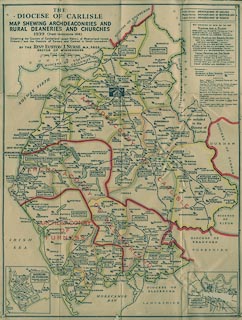
Map, The Diocese of Carlisle, Cumberland, Westmorland,
and Lancashire North of the Sands, scale about 4 miles to 1
inch, by Rev Euston J Nurse, published by Charles Thurnam
and Sons, 11 English Street, Carlisle, Cumberland, 2nd edn
1939.
|
||

|
Nurse 1918 | |
| map feature:- | folded & card cover & plain cartouche & up is N & scale line & sea plain & coast line & coast form lines & rivers & lakes & settlements & railways & ecclesiastical areas | |
| inscription:- |
printed title cartouche, upper left
THE / DIOCESE OF CARLISLE / MAP SHOWING ARCHDEACONRIES AND / RURAL DEANERIES AND CHURCHES / 1939 (FIRST IMPRESSION 1918) / Comprising the Counties of Cumberland (except Alston), of Westmorland (except / Firbank) and the Districts of Furness and Cartmel in North Lancashire. / BY THE REVD. EUSTON J. NURSE, M.A., F.R.G.S / RECTOR OF WINDERMERE |
|
| scale line:- | 10 miles = 64.4 mm | |
| scale:- | 1 to 250000 ? (1 to 249898 from scale line) | |
| wxh, sheet:- | 41x53.5cm | |
| wxh, folded:- | 10.5x15.5cm | |
| wxh, map:- | 398x524mm | |
|
||