 Ptolemy 1793

|

|
|
|
item:- Hampshire Museums : FA2002.651 image:- © see bottom of page |
click to enlarge |
|
|
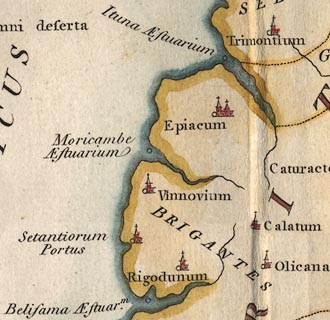
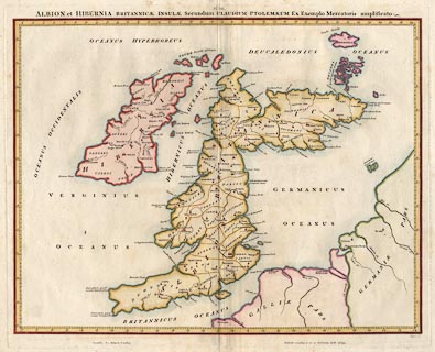
Map, hand coloured engraving, Albion et Hibernia
Britannicae Insulae, from the data of Claudius Ptolemy, 2nd
century, on the example of Gerard Mercator, 16th century,
scale about 55 miles to 1 inch, engraved by Basire,
published for the Society of Antiquaries, 1793.
|
||

|
Ptolemy 1793 | |
| map feature:- | up is N & lat and long scales & sea plain & coast form lines & rivers & tribal areas & settlements | |
| inscription:- |
printed top
ALBION et HIBERNIA BRITANNICAE INSULAE Secundum CLAUDIUM PTOLOMAEUM Ex Exemplo Mercatoris amplificato |
|
| inscription:- |
printed bottom
Basire sc. / Sumptibus Soc. Antiquar, Londini Publish'd according to act of Parliament, April 23d. 1793. |
|
| wxh, sheet:- | 64.5x53.5cm | |
| wxh, plate:- | 577x467mm | |
| wxh, map:- | 558x435mm | |
| scale:- | 1 to 3500000 ? (estimated from London-York and London-Bath distances) | |
|
||