 Jenkinson 1875 map 1

|

|
|
|
item:- JandMN (28_1) image:- © see bottom of page |
click to enlarge |
|
|
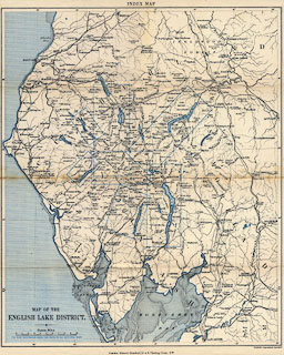
Map of the English Lake District, Westmorland, Cumberland
and Lancashire, ?colour lithograph, scale about 4 miles to 1
inch, by Stanford's Geographical Establishment, published by
Edward Stanford, 55 Charing Cross, London, 1875.
Inserted in a pocket in the front cover of A Practical Guide to the English Lake District, by Henry Irwin Jenkinson, 4th edition 1875. As well as being a general map of the area, the map functions as an index map by showing the coverage of detail maps by rectangles. The railways are named. |
||

|
Jenkinson 1875 map 1 | |
| map feature:- | colour printed & up is N & scale line & lat and long scales & sea shaded (blue) & coast line & rivers & lakes & county & settlements & roads & railways & index map | |
| inscription:- |
printed lower left
MAP OF THE / LAKE DISTRICT. |
|
| inscription:- |
printed top centre
INDEX MAP |
|
| inscription:- |
printed bottom, centre and right
London : Edward Stanford, 55 & 8. Charing Cross, S.W. / Stanford's Geographical Establisht. |
|
| scale line:- | 10 miles = 63.4 mm | |
| scale:- | 1 to 250000 ? (1 to 253840 from scale line) | |
| wxh, sheet:- | 31x37.5cm | |
| wxh, map:- | 295x354mm | |