 Map History

|

|
|
|

|
start | ||
|
|
previous | ||
|
The Lakes What is different from other counties about the mapping of the area of Westmorland, Cumberland, and Lancashire north of the sands, is maps of The Lakes. The Lakes was recognized as a distinct area as tourism developed from the latter 18th century onwards, and maps were soon provided in addition to the usual range of county maps. One of the earliest was:-
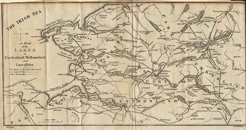 A Map of the Lakes in Cumberland, Westmorland and
Lancashire, scale about 3.5 miles to 1 inch, engraved by
Paas, London, about 1784; (375x191mm).
A Map of the Lakes in Cumberland, Westmorland and
Lancashire, scale about 3.5 miles to 1 inch, engraved by
Paas, London, about 1784; (375x191mm).
which was included in Thomas West's Guide to the Lakes, from its 3rd edn, 1784; first edition of the book was in 1778, regarded as the first guide book to the lakes telling you what you should see, as different from tours which report what the author did see. This map is issued in later editions with improvements. Other map makers follow, drawing better and better maps, in some cases at least, for example; Cary 1798, Lowes c1800, Cooke 1802, Feltham 1803, Mawman 1805, Faden 1810, Hebert 1816, Otley 1818. ... The Cooke map of 1802 has its own page in an atlas of county maps. The map by Jonathan Otley is by a well known local author, geologist, etc living in Keswick:-
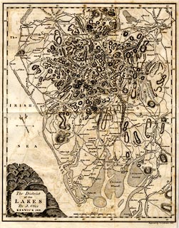 The District of the Lakes, scale about 4 miles to 1 inch,
by Jonathan Otley, Keswick, Cumberland, 1818, engraved by J
and G Menzies, Edinburgh, published by R Lough and Co,
Chronicle Office, Finkle Street, Kendal, and others, 1820;
(256x321mm).
The District of the Lakes, scale about 4 miles to 1 inch,
by Jonathan Otley, Keswick, Cumberland, 1818, engraved by J
and G Menzies, Edinburgh, published by R Lough and Co,
Chronicle Office, Finkle Street, Kendal, and others, 1820;
(256x321mm).
His map is followed by a guide book in 1823 and both map and guide book are issued in a number of editions - the book to an 8th edition 1849. His map is issued again, perhaps pirated, in a Red Guide to The Lakes in 1892. The production of maps of The Lakes continues up to the present. |
|||
|
Lakes Maps were soon made of individual lakes alone or in groups. Peter Crosthwaite, Keswick, published a series of lake maps beteween 1783 and 1794, mapping Derwent Water, Ullswater, Bassenthwaite Lake, Coniston Water, Buttermere, Crummock Water and Loweswater at 3 inches to 1 mile, and Windermere at 2 inches to 1 mile. He continues Thomas West's idea of declared 'stations' where to view the scenery, marking West's and his own stations on his maps.
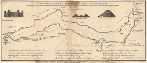
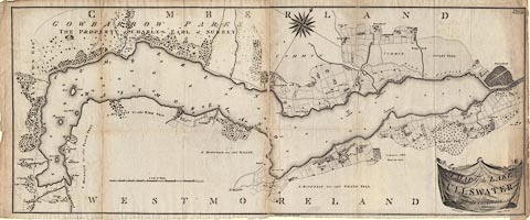 A rival series of lake maps was published by James Clarke, Penrith, in 1787. Their scale was better, about 6 inches to 1 mile, and the quality of engraving better as well. Peter Crosthwaite was not at all happy about them. Peter Crosthwaite made marginal notes in a copy of James Clarke' Survey of the Lakes, on page 69 (diffciult to read in places):- [Here our new Author makes all the Islands on Derwent about 13 Acres, & at the same time has made Lords Island to measure 25 Acres in his Map of Derwent & thus he has blasted both his credit as a Lake Surveyor & Land Surveyor. He has also made all the Islands together above 60 Acres & given no one of them either their proper place, or size, or form! He has for instance made Rampsholm 6 times larger than it ought to be, & laid it length ways across the Water the very reverse of its real direction & Otter Island is made about 50 times larger than it should be with the coasts of the Lake no better Executed In short our Pompous Author has Disguised Poor old Derwent & Likewise the Lake of Bassenthwaite to all intents & purposes as will plainly appear from any high Eminence near them; The North & South line in Derwent is wrong by 25 Degrees & Bassenthwaite by 90! & His other two Lakes are fare from Accurate nor are the Maps of Roads & Country better, there being many confounded Errors. The Maps likewise are taken from 6 different Scales which is no credit to the Surveyor, as by this means it is difficult to Judge what proportion one Lake bears to another] I have compared the shape of one lake, Ullswater, of each of their maps and the shape on the Ordnance Survey. Peter Crosthwaite's map of Ullswater is more accurate, but being smaller and less well engraved, is less convincing - buyer beware. Maps of lakes in one or groups are still being produced today, usually coloured, and usually including the locations of places of interest to the tourists who now fill up hotels, lodges and campsites every season. |
|||
|
|
|||
Lakes Guides menu.