 Gibson 1766

|

|
|

|
back to object record | |
| Map Features | ||
|
The parts of the road outwith Cumbria and a relevant part of
Lancashire are mostly ignored.
|
||
|
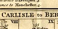
The map is arranged in strips, scrolls, numbered I to X, and
has two routes on the one sheet:-
|
||
London to Carlisle - from Darlaston Bridge, Staffordshire; through Cheshire; to Lancaster, Lancashire; then Burton, Kendal, Shap, Westmorland; to Penrith and Carlisle, Cumberland. |
||
Carlisle to Berwick - from Carlisle, Cumberland, across Kershope Burn and through Jedburgh, Kelso, Scotland; to Berwick, Northumberland. |
||
|
|
||
|
title
map maker publisher |
Printed top right is:-
Gent: Mag: Each route has a title in a plain cartouche at the top:- A Correct MAP of the ROAD from LONDON to CARLISLE, commencing at Darlaston Bridge, in the CHESTER ROAD. The ROAD from CARLISLE to BERWICK. Printed bottom right is:- Drawn & Engraved by J. Gibson. |
|
|
|
||
|
orientation
up is destination |
The strips are arranged with the destination at the top;
you read the road from the bottom of the leftmost scroll to
its top, continue at the bottom of the next scroll to its
top, and so on. There is no indication of compass direction
on the scrolls.
|
|
|
|
||
| scale |
There is no indicator of scale except the numbered mile marks on the routes. These can be used to estimate a map scale, about:- 1 to 240000 3.5 miles to 1 inch |
|
|
|
||
|
rivers
bridges |
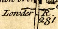
Rivers are mostly drawn by a wiggly line crossing under the road. The River Tweed at Berwick is a double line with stream lines. The larger rivers are labelled, eg:- Kent R. Lowder R. Eden R. Bridges are just implied by the road crossing and interrupting the stream. But a bridge might be labelled, eg:- 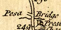
Pesa Bridge Nether bri. [Kendal] Emon bri. [Eamont Bridge] |
|
|
|
||
|
relief
hillocks |
Some relief on the routes, the ups and downs, are
indicated by hillocks. These are all drawn the 'right way
up' and do indicate whether a hill is an ascent or descent.
A hill might be labelled, eg:-
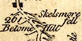
Betome Hill Skelsmore fell In some places a row of hillocks suggests a ridge route, for example north of Hesket, mile 292-293 on the London to Carlisle road:- 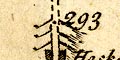
Hills might be drawn, as a landmark, beside the road, eg:- 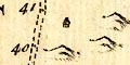
40 miles from Carlisle towards Berwick. |
|
|
|
||
| county |
County boundaries are a dotted line across the route,
with a label naming the county into which the traveller
goes, eg:-
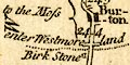
enter Westmoreland at the Birk Stone, mile 243 1/2 on the London to Carlisle route, and:- enter Cumberland at Eamont Bridge, mile 281 1/2. The county through which the route goes is labelled along the side of the scroll, eg:- WESTMORELAND CUMBERLAND |
|
|
|
||
| forests |
Woodland is not indicated but a forest might be labelled,
eg:-
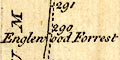
Englewood Forrest at mile 289-290 on the London to Carlisle road. |
|
|
|
||
| parks |
A park might be marked by a ring, or part ring, of fence
palings, and labelled, eg:-
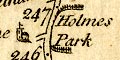
Holmes Park adjoining the London to Carlisle road at mile 246-247. |
|
|
|
||
|
settlements
street map |
Settlements are marked by blocks or by building symbols,
differentiated by style of labelling.
|
|
| city |
blocks on a minimal street plan; labelled in upright
block caps, eg:-
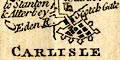
CARLISLE which has a town wall, perhaps bastions, and gates labelled:- English Gate Scotch Gate Notice that Lancaster which lacks a cathedral is labelled in italic block caps. |
|
| towns |
blocks, perhaps a minimal street plan; labelled in
upright lowercase text, eg:-
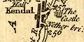
Kendal Penrith Burton-in-Kendal and Shap are also shown as towns. |
|
|
villages
hamlets |
blocks, on the road, or a church, off the road; labelled
in italic lowercase text, eg:-
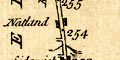
Natland [blocks, on the road] 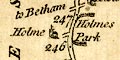
Holme [church, off the road] Instead of a village a chapel might be labelled, eg:- Preston Chapel marked by the church on its hill, by mile 246 1/2 on the London to Carlisle road. |
|
| houses |
An important house might be marked by a building symbol,
labelled, eg:-
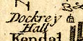
Dockrey Hall in Kendal, by mile 257 in the London to Carlisle road. |
|
| castles |
A castle might be marked by a building with two towers,
labelled, eg:-
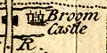
Broom Castle [Brougham Castle] in mile 281-282 by the London to Carlisle road. |
|
|
|
||
|
roads
road distances distances from London |
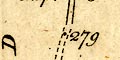
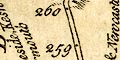
The road is drawn down the middle of each scroll by a double line, solid or dotted probably indicating fenced and unfenced road. Bends are probably smoothed out to keep the road on the slim scroll. Road distances are marked by a dot in the road and labelled by number of miles from the start of each route; in these roads that is London or Carlisle. The marks are fairly, but not exactly evenly spaced, and provide the only indication of scale. Road junctions are marked, and often labelled with where they go, eg:- 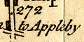
to Appleby to Hutton Hall to the Moss Sometimes a route is described more fully, eg:- to Ambleside, Keswick & Cockermouth |
|
|
|
||
| miscellaneous | ||
|
|
||
| stones |
Just before the Westmorland boundary at mile 243 1/2 on
the London to Carlisle road is a stone labelled:-
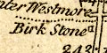
Birk Stone South of Shap about mile 270 1/2 on the London to Carlisle road are three blocks labelled:- 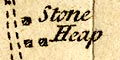
Stone Heap |
|
Lakes Guides menu.