|
|
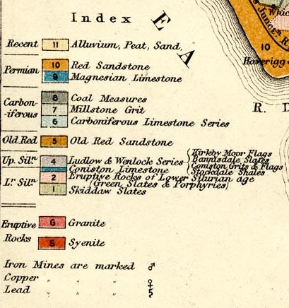
A Geological Map of the Lake District, scale about 6 miles
to 1 inch, reduced from that of John Ruthven and others, was
included in Ascents and Passes in the Lake District, by
Herman Prior, published by John Garnett, Windermere,
Westmorland, 1865. The stratigraphical column was:-
|
|
|
Recent / 11 / Alluvium, Peat, Sand
Permian / 10 / Red Sandstone
... / 9 / Magnesian Limestone
Carboniferous / 8 / Coal Measures
... / 7 / Millstone Grit
... / 6 / Carboniferous Limestone Series
Old Red / 5 / Old Red Sandstone
Up. Siln. / 4 / Ludlow and Wenlock Series /
Kirkby Moor Flags, Bannisdale Slates, Coniston Grits and
Flags, Stockdale Shales
Lr. Siln. / [3] / Coniston Limestone
... / 2 / Eruptive Rocks of Lower Silurian age /
(Green Slates and Porphyries)
... / 1 / Skiddaw Slates
Eruptive Rocks / G / Granite
... / S / Syenite
|