 Cruchley 1870s

|

|
|

|
back to object record | |
| MAP FEATURES | ||
|
|
||
|
title
map maker toy maker publisher |
Printed on the jigsaw:-
CRUCHLEY'S TRAVELLING RAILWAY MAP OF ENGLAND AND WALES PUBLISHED BY GALL & INGLIS, EDINBURGH Printed label on box:- SUPERIOR DISSECTED MAPS BY W. PEACOCK. ENGLAND & WALES PUB BY WILLIAM PEACOCK, LONDON Printed label on underside of box:- CHARLES HENRY 22 KING ST. MANCHESTER |
|
|
|
||
|
orientation
up is N |
The map is printed with North at the top.
|
|
|
|
||
|
scale line
scale |
There is a scale line, 70 miles = 94.1 mm, approximately,
giving a map scale 1 to 1232539. The map scale is
about:-
1 to 1200000 ? 20 miles to 1 inch |
|
|
|
||
|
sea area
sea plain |
The sea area is plain. Some sea areas are labelled, eg:- Bay of Morecambe SOLWAY FRITH Allonby Bay |
|
|
|
||
|
coast line
coast shaded headlands |
The coast line is emphasized by two sets of shading, one extended further into the offing. One group of headlands is noticed:- St. Bees Heads |
|
|
|
||
|
rivers
bridges |
Rivers are drawn by wiggly line tapering upstream. Some rivers are labelled, eg:- Eden R. R. Eden Bridges are implied where a road crosses and interrupts a stream. |
|
|
|
||
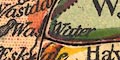
| lakes |
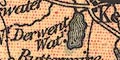
Lakes are drawn in outline with from lines. Some lakes are labelled:- Bassenthwaite Water & Vill. Buttermere Coniston Water Crummock Water Derwent Wat. Ennerdale Wr. Hals Watr. [Hawes Water] Loweswater Thirl Meer Wast Water Winander Meer [Ullswater] Other might be recognized, eg:- Brothers Water Burnmoor Tarn (?) |
|
|
|
||
| forests |
Woodland is not noticed, but a forest might be labelled,
eg:-
Milburn Forest |
|
|
|
||
| county |
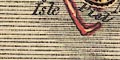
County boundaries are a dotted line. The inner side of each county is tinted, the county area given a paler wash of the same colour; Westmorland green, Cumberland orange, Lancashire yellow, Northumberland green, Durham yellow, North Yorkshire pink. The county areas are labelled, eg:- WESTMORELAND The map is cut out county by county, fairly true to the printed borders; Yorkshire is cut in two with an interlocking join. |
|
|
|
||
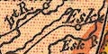
| settlements |
Settlements are marked by a circle or blocks,
differentiated by style of labelling.
|
|
| cities |
group of blocks and a confluence of roads; labelled in
upright block caps:-
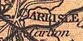
CARLISLE |
|
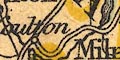
| towns |
blocks; labelled in upright lowercase text, eg:-

Penrith Appleby Kendal |
|
|
villages
hamlets |
circle; labelled in italic lowercase text, eg:-
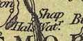
Shap Bewcastle |
|
|
|
||
|
roads
sands roads |
A network of roads is drawn by double and single line. The sands roads are not marked, but a label on Lancaster Sands states:- [f]ordable [at] Low Water |
|
|
|
||
| railways |
Railways are drawn by a triple line, light bold light (this symbol is more often used for canals). It is not clear where there are stations. The following railways are shown in Cumbria (roughly):- |
|
| Maryport and Carlisle Railway |
opened 1845
from Maryport, through Wigton, to Carlisle, Cumberland. |
|
| Lancaster and Carlisle Railway |
opened 1846
from Lancaster, through Carnforth, Lancashire; near Kendal, Westmorland; then Penrith to Carlisle, Cumberland. |
|
| Kendal and Windermere Railway |
opened 1846
from the Lancaster and Carlisle Railway, through Kendal, to 'Bownes', Westmorland. |
|
| Cockermouth and Workington Railway |
opened 1847
from Cockermouth to Workington, Cumberland. |
|
| Whitehaven Junction Railway |
opened 1847
from Whitehaven, through Workington, to Maryport, Cumberland. |
|
| Caledonian Railway |
opened 1850
from Carlisle, Cumberland; to Gretna and beyond, Scotland. |
|
| Ulverstone and Lancaster Railway |
opened after 1851
from Ulverston, to Carnforth and Lancaster, Lancashire. |
|
| Newcastle and Carlisle Railway |
opened 1852
from the east through Haltwhistle, Northumberland; near Bampton, to Carlisle, Cumberland. |
|
| Port Carlisle Dock and Railway |
opened 1854
from Carlisle, to the coast of the Solway Firth, Cumberland. |
|
| Whitehaven, Cleator and Egremont Railway |
opened 1856-57
from Whitehaven, to Egremont, and a route through Cleator, Cumberland. |
|
| Carlisle and Silloth Bay Railway |
opened 1857
branch off the Port Carlisle Dock and Railway, to Silloth, Cumberland. |
|
|
North Western Railway
Low Gill and Ingleton branch railway |
opened 1859?
from the south, Lancashire; near Kirkby Lonsdale, to the Lancaster and Carlisle Railway, Westmorland. |
|
| Coniston Railway |
opened 1859-60
from Broughton to Coniston, Lancashire. |
|
| South Durham and Lancashire Union Railway |
opened 1861
from Tebay, through Kirkby Stephen, Westmorland; east into Yorkshire and Durham. |
|
| Border Union Railway |
opened 1861
from Carlisle, through Longtown, Cumberland; into Scotland. |
|
| Eden Valley Railway |
opened 1862
from Kirkby Stephen or Brough, through Appleby, to the Lancaster and Carlisle Railway at Clifton, Westmorland. |
|
| Cockermouth, Keswick and Penrith Railway |
opened 1864-65
from Cockermouth, through Keswick, to Penrith, Cumberland. |
|
| Furness Railway |
opened 1867
from Broughton, to Piel Pier, Lancashire; branch through Dalton to Ulverston, Lancashire; branch to Barrow, Lancashire. |
|
| Settle and Carlisle Railway |
opened 1876
from Settle, Yorkshire; through Kirkby Stephen, Appleby, Westmorland; to Carlisle, Cumberland. |
|
|
The railways suggest a date for the map in the 1870s.
|
||
|
|
||
| canals |
Canals are drawn by a triple line, light bold light. The
only canal that can be made out is the
|
|
| Lancaster Canal |
from Lancaster, Lancashire; to Kendal, Westmorland.
|
|
|
|
||
| miscellaneous | ||
|
|
||
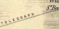
| telegraphs |
A telegraph line is shown by a double line across the
Irish Sea sea from Whitehaven:-
TELEGRAPH |
|
|
|
||
|
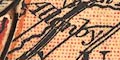
antiquities
roman wall |
Hadrian's Wall is marked by a line with fence palings,
from Carlisle eastward, labelled:-

Picts Wall |
|
Lakes Guides menu.