 Balderston c1890 map

|

|
|

|
back to object record | |
| MAP FEATURES | ||
|
|
||
| folded |
The map is tipped in opposite page 1 of the guide book,
folded, with the inevitable damage from use.
|
|
|
|
||
|
title
author engraver |
The map is not titled, but the author of the guide book
is the likely map make. Although the book title is Ingleton,
the map shows the area north east of the village, the
streams, caves and potholes about Gragareth, Ingleborough,
and Whernside.
Printed lower right is:- Goodall & Suddick. Leeds. |
|
|
|
||
|
orientation
compass rose up is N |
Printed lower left is a compass rose; no circle, star points for cardinal and half cardinal directions, an extended N-S line, North marked by an arrow. The map is printed with North at the top of the sheet. |
|
|
|
||
| scale |
Printed lower left is:-
SCALE. ONE MILE TO THE INCH. The nominal map scale is:- 1 to 63360 (?) 1 inch to 1 mile |
|
|
|
||
| table of symbols |
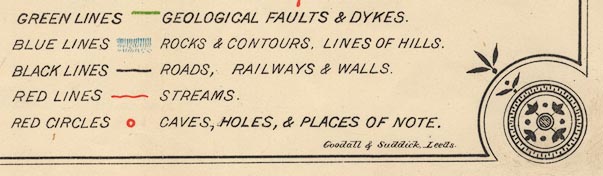
Printed lower right is a table of symbols:- GREEN LINES [green line] GEOLOGICAL FAULTS & DYKES. BLUE LINES [blue hachures] ROCKS & CONTOURS. LINES OF HILLS. BLACK LINES [black line] ROADS, RAILWAYS & WALLS. RED LINE [wiggly red line] STREAMS. RED CIRCLES [red circle] CAVES, HOLES, & PLACES OF NOTE. These make for a colourful and readable map, even if some of the colours are unexpected. |
|
|
|
||
| rivers |
Rivers are drawn by wiggly red lines. Many small as well
as large rivers are shown, and many are labelled, eg:-
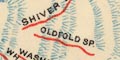
SHIVER SPRING / OLDFOLD SP. RIVER RIBBLE DOE OR DALE RIVER LONG GILL GALE BECK OR UPPER RIBBLE KINGS DALE USUALLY DRY There might be a taper, or pattern of tributaries, hinting which way a river flows, but the hill hachures are a better clue. Be prepared for a steam to stop, swallowed in a pothole, or just sinking through its bed. Note the label:- UNDERGROUND COURSE in the line of the River Doe. A waterfall might be marked by a line across a stream, or might just be labelled, eg:- 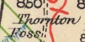
Thornton Foss Fall Foss |
|
|
|
||
| lakes |
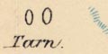
Two groups of tarns are drawn in outline and each labelled on Whernside:- Tarn |
|
|
|
||
|
relief
hill hachuring contours spot heights caves |
Relief is indicated by hill hachuring in blue, along
contours of the hills. Some of the contour hachures might be
labelled, the hill named, and a spot height given, eg:-
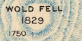
WOLD FELL / 1829 / 1750 / 1500 / 1250 [no spot mark] The summit might be marked by a red circle or a black triangle. Eg:- GREY GARETH / 2250 [red circle] CASTLE KNOTT [black triangle] The method of showing relief presents a fairly effective idea of the landscape. Edges, fells, valleys, etc might also be labelled, eg:- TWISLETON SCARS CASTERTON FELL LUL GILL GREEN LAW MOOR But beware the similar labels which are underlined, which are descriptive terms, not names, eg:- 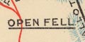
OPEN FELL PASTURES This distinction is an unusual, but helpful, feature. But may not be used consistently, see:- MOORLAND ALLOTMENTS not underlined. Five roughly parallel green lines NW-SE through Ingleton and north east of the village, mark fault lines or dykes. Numerous caves, potholes, and shakeholes are marked by a red circle, labelled in italic lowercase text, eg:- 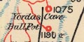
Yordas cave Gingle Pot Shakes Holes Note that there is not a total correspondence between which caves are plotted and which are described in the guide book text. And, in some cases, the spellings of the name in the two sources differ. |
|
|
|
||
| settlements |
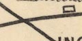
Settlements are marked by one or more black rectangles
(open, not filled blocks), differentiated by style of
labelling. Churches are marked by a cross (+).
|
|
|
towns
villages hamlets |
rectangles; labelled in upright block caps, eg:-
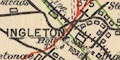
INGLETON BLACK BURTON CHAPEL-LE-DALE NEWBY COTE |
|
|
hamlets
houses |
rectangle; labelled in italic lowercase text, eg:-
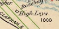
High Leys Scaleber High Threaber Hall This lettering is use for all sorts of features. |
|
|
|
||
| roads |
Roads, or just tracks, are drawn by a bold black line; but according to the table of symbols a wall might be shown this way as well - and they intersect? Some roads are labelled, eg:- TURBURY ROAD ROAD TO KIRKBY LONSDALE FELL ROAD TO DENT Whatever it says don't rely on a made up road today! Some roads are drawn by a double dotted line. |
|
|
|
||
| railways |
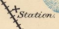
Railways are drawn by a black line with cross lines. Stations are sometimes marked by a black rectangle, and labelled:- Station Two railways are shown:- |
|
| Settle and Carlisle Railway |
from the south, through stations near Horton in
Ribblesdale, Ribble Head, the very detached station for
Dent, and to the north.
SETTLE AND CARLISLE RAILWAY The tunnel under Blea Moor is drawn by a double line, no cross lines, labelled:- TUNNEL |
|
| Low Gill and Ingleton branch railway |
from the south, through stations for Ingleton, Kirkby
Lonsdale, Barbon, and Middleton, and to the north. Labelled
north and south of Ingleton:-
LONDON & NORTH WESTERN RAILWAY MIDLAND RAILWAY |
|
|
|
||
| miscellaneous | ||
|
|
||
|
antiquities
roman sites roman forts |
A roman fort is drawn by a red oval, labelled:-
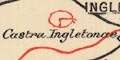
Castra Ingletonae |
|
Lakes Guides menu.