 Bartholomew c1900

|

|
|

|
back to object record | |
| Bartholomew c1900 | ||
|
Geological Map of the British Isles, scale about 63 miles to
1 inch, published by John Bartholomew, Edinburgh, about
1900?
|
||
|
REFERENCE TO COLOURING
|
||
|
||
|
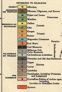
The layout of eras, periods, etc is unclear. The strata
are:-
|
||
|
RECENT --- 18 Alluvium CAINOZOIC OR TERTIARY --- 17/16 Pliocene, Oligocene, and Eocene / Upper and Lower MESOZOIC OR SECONDARY - Cretaceous --- 15 Wealden --- 14 Oolites - Jurassic --- 13 Lias --- 12 Keuper - Triassic --- 11 Bunter --- 10 Magnesian Limestone PALAEOZOIC OR PRIMARY - Permian --- 9 Red Marls - Carboniferous --- 8 Coal Measures --- 7 Millstone Grit, Culm Measures --- 6 Carboniferous Limestone - [Devonian] --- 5 Devonian and Old Red Sandstone - [Silurian] --- 4 Upper Silurian --- 3 Lower Silurian - [Cambrian] --- 2 Cambrian PRE CAMBRIAN --- 1 Torridonian, including Uriconian and Longmynd --- M Crystalline Schists of various ages including Lewisian or Hebridian Gneiss - --- [] Igneous |
||
Lakes Guides menu.