 Old Cumbria Gazetteer
 |
 |
|
| Ibbotsholme, Troutbeck Bridge | ||
| Ibbotsholme | ||
| locality:- | Troutbeck Bridge | |
| civil parish:- | Lakes (formerly Westmorland) | |
| county:- | Cumbria | |
| locality type:- | building/s (? still?) | |
| coordinates:- | NY40260057 | |
| 1Km square:- | NY4000 | |
| 10Km square:- | NY40 | |
|
|
||
| evidence:- | old map:- OS County Series (Wmd 32 3) placename:- Ibbotsholme |
|
| source data:- | Maps, County Series maps of Great Britain, scales 6 and 25
inches to 1 mile, published by the Ordnance Survey, Southampton,
Hampshire, from about 1863 to 1948. "Ibbotsholme" |
|
|
|
||
| evidence:- | probably old map:- Garnett 1850s-60s H placename:- Abbots Holme |
|
| source data:- | Map of the English Lakes, in Cumberland, Westmorland and
Lancashire, scale about 3.5 miles to 1 inch, published by John
Garnett, Windermere, Westmorland, 1850s-60s.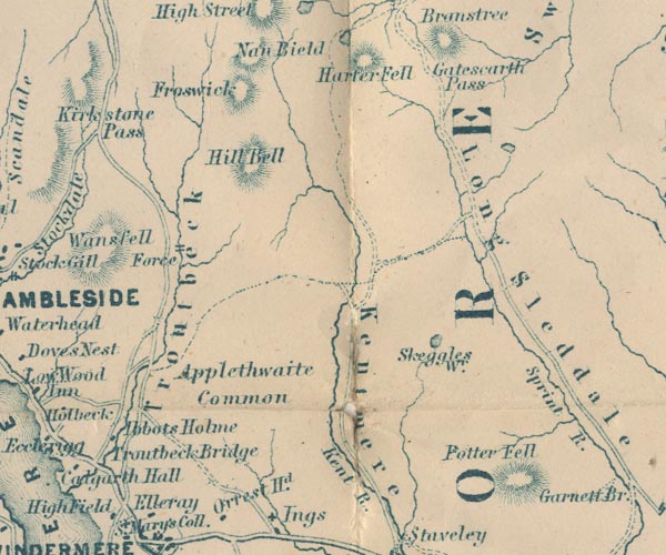 GAR2NY40.jpg "Abbots Holme" block, building item:- JandMN : 82.1 Image © see bottom of page |
|
|
|
||
| evidence:- | old text:- Martineau 1855 |
|
| source data:- | Guide book, A Complete Guide to the English Lakes, by Harriet
Martineau, published by John Garnett, Windermere, Westmorland,
and by Whittaker and Co, London, 1855; published 1855-76. goto source goto sourcePage 43:- "... after turning into the Ambleside road from Bowness, first, Ibbotsholme, on the right, the residence of Samuel Taylor, Esq., just beyond Troutbeck Bridge. ..." |
|
|
|
||
| evidence:- | old map:- Prior 1874 map 1 placename:- Ibbots Holme |
|
| source data:- | Map, uncoloured engraving or lithograph? Winander Mere, scale
about 2.5 miles to 1 inch, published by John Garnett,
Windermere, Westmorland, 1874. click to enlarge click to enlargePI03M1.jpg "Ibbots Holme" block/s; building/s item:- private collection : 133.1 Image © see bottom of page |
|
|
|
||
Lakes Guides menu.