 Old Cumbria Gazetteer
 |
 |
|
| School Beck Bridge, Coniston | ||
| School Beck Bridge | ||
| site name:- | School Beck | |
| locality:- | Water Head | |
| civil parish:- | Coniston (formerly Lancashire) | |
| county:- | Cumbria | |
| locality type:- | bridge | |
| coordinates:- | SD31419797 | |
| 1Km square:- | SD3198 | |
| 10Km square:- | SD39 | |
|
|
||
| evidence:- | old map:- OS County Series (Lan 4 4) placename:- School Beck Bridge |
|
| source data:- | Maps, County Series maps of Great Britain, scales 6 and 25
inches to 1 mile, published by the Ordnance Survey, Southampton,
Hampshire, from about 1863 to 1948. |
|
|
|
||
| evidence:- | old map:- Crosthwaite 1783-94 (Con) |
|
| source data:- | Map, uncoloured engraving, An Accurate Map of Coniston Lake,
scale about 3 inches to 1 mile, by Peter Crosthwaite, Keswick,
Cumberland, 1788, version published 1809.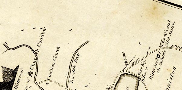 CTESD39E.jpg road across a stream item:- JandMN : 182.5 Image © see bottom of page |
|
|
|
||
| evidence:- | perhaps old drawing:- Aspland 1840s-60s |
|
| source data:- | Drawing, pencil and ink wash, Coniston Water, Cumberland, by Theophilus Lindsey Aspland,
1849.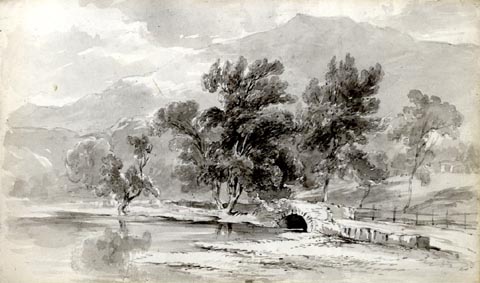 click to enlarge click to enlargeAS0177.jpg item:- Armitt Library : 1958.487.77 Image © see bottom of page |
|
|
|
||
 Lakes Guides menu.