 Old Cumbria Gazetteer
 |
 |
|
| Brayton Park, Brayton | ||
| Brayton Park | ||
| Brayton Hall | ||
| locality:- | Brayton | |
| civil parish:- | Aspatria (formerly Cumberland) | |
| county:- | Cumbria | |
| locality type:- | park | |
| locality type:- | building/s (once) | |
| coordinates:- | NY16524271 (etc) | |
| 1Km square:- | NY1642 | |
| 10Km square:- | NY14 | |
|
|
||
| evidence:- | old map:- OS County Series (Cmd 36 6) placename:- Brayton Hall |
|
| source data:- | Maps, County Series maps of Great Britain, scales 6 and 25
inches to 1 mile, published by the Ordnance Survey, Southampton,
Hampshire, from about 1863 to 1948. "Brayton Hall" at NY16884251. |
|
|
|
||
| evidence:- | old map:- Donald 1774 (Cmd) placename:- Brayton Hall |
|
| source data:- | Map, hand coloured engraving, 3x2 sheets, The County of Cumberland, scale about 1
inch to 1 mile, by Thomas Donald, engraved and published by Joseph Hodskinson, 29
Arundel Street, Strand, London, 1774.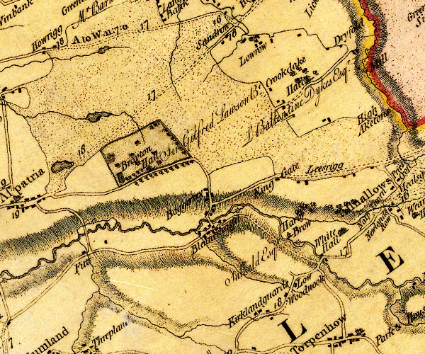 D4NY14SE.jpg "Brayton Hall / Sir Gilfried Lawson Bt." house in double outline with suggested fence palings; a park, and trees, pond, etc item:- Carlisle Library : Map 2 Image © Carlisle Library |
|
|
|
||
| evidence:- | road book:- Cary 1798 (2nd edn 1802) placename:- Brayton Hall |
|
| source data:- | Road book, itineraries, Cary's New Itinerary, by John Cary, 181
Strand, London, 2nd edn 1802. goto source goto source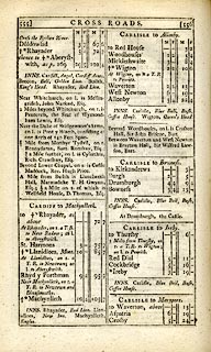 click to enlarge click to enlargeC38555.jpg page 555-556 "Between Waverton and West Newton is Brayton Hall, Sir Wilfrid Lawson, Bart." goto source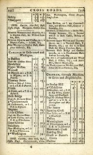 click to enlarge click to enlargeC38557.jpg page 557-558 "Between Waverton and Aspatria, on l. is Brayton Hall, Sir Wilfrid Lawson, Bart." item:- JandMN : 228.2 Image © see bottom of page |
|
|
|
||
| evidence:- | old map:- Cooke 1802 placename:- Brayton Hall |
|
| source data:- | Map, Cumberland, scale about 15.5 miles to 1 inch, by George
Cooke, 1802, bound in Gray's New Book of Roads, 1824, published
by Sherwood, Jones and Co, Paternoster Road, London, 1824. click to enlarge click to enlargeGRA1Cd.jpg "Brayton Hall" building AND outline of fence palings; park item:- Hampshire Museums : FA2000.62.2 Image © see bottom of page |
|
|
|
||
| evidence:- | old map:- Wallis 1810 (Cmd) placename:- Brayton Hall |
|
| source data:- | Road map, hand coloured engraving, Cumberland, scale about 16
miles to 1 inch, by James Wallis, 77 Berwick Stree, Soho,
London, 1810. click to enlarge click to enlargeWL13.jpg "Brayton Hall" House and outline with fence palings; park item:- Dove Cottage : 2009.81.10 Image © see bottom of page |
|
|
|
||
| evidence:- | old map:- Hall 1820 (Cmd) placename:- Brayton Hall |
|
| source data:- | Map, hand coloured engraving, Cumberland, scale about 21 miles
to 1 inch, engraved by Sidney Hall, published by S Leigh, 18
Strand, London, 1820-31. click to enlarge click to enlargeHA14.jpg "Brayton Hall" outline of fence palings; park and house item:- JandMN : 91 Image © see bottom of page |
|
|
|
||
| evidence:- | old map:- Ford 1839 map placename:- Brayton Hall |
|
| source data:- | Map, uncoloured engraving, Map of the Lake District of
Cumberland, Westmoreland and Lancashire, scale about 3.5 miles
to 1 inch, published by Charles Thurnam, Carlisle, and by R
Groombridge, 5 Paternoster Row, London, 3rd edn 1843.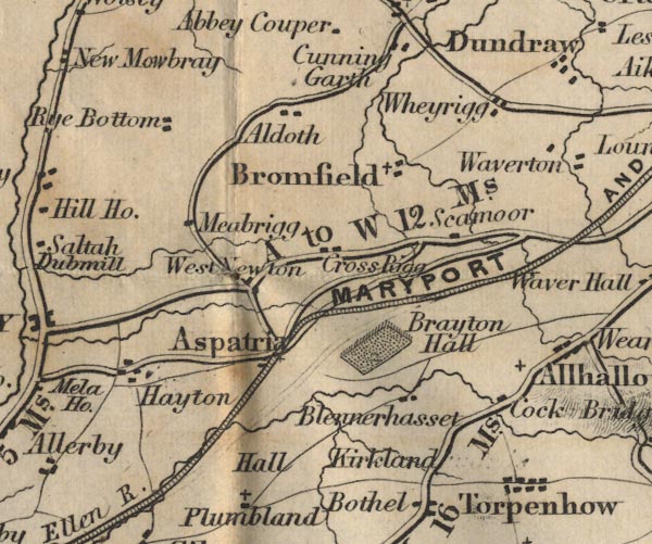 FD02NY14.jpg "Brayton Hall" Park. item:- JandMN : 100.1 Image © see bottom of page |
|
|
|
||
| evidence:- | old map:- Garnett 1850s-60s H placename:- Brayton Hall |
|
| source data:- | Map of the English Lakes, in Cumberland, Westmorland and
Lancashire, scale about 3.5 miles to 1 inch, published by John
Garnett, Windermere, Westmorland, 1850s-60s.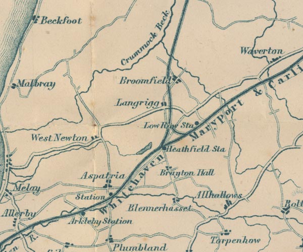 GAR2NY14.jpg "Brayton Hall" blocks, settlement item:- JandMN : 82.1 Image © see bottom of page |
|
|
|
||
| evidence:- | old print:- Calverley 1899 item:- fibula; Brayton Fibula |
|
| source data:- | Found when deepening a fish pond at Brayton Park, now in a museum in York:-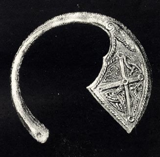 click to enlarge click to enlargeCV1156.jpg from Pennant. item:- JandMN : 190 Image © see bottom of page |
|
|
|
||
Lakes Guides menu.