 Old Cumbria Gazetteer
 |
 |
|
| Stonethwaite Bridge, Stonethwaite | ||
| Stonethwaite Bridge | ||
| site name:- | Stonethwaite Beck | |
| locality:- | Stonethwaite | |
| civil parish:- | Borrowdale (formerly Cumberland) | |
| county:- | Cumbria | |
| locality type:- | footbridge | |
| locality type:- | bridge | |
| coordinates:- | NY26331383 | |
| 1Km square:- | NY2613 | |
| 10Km square:- | NY21 | |
|
|
||
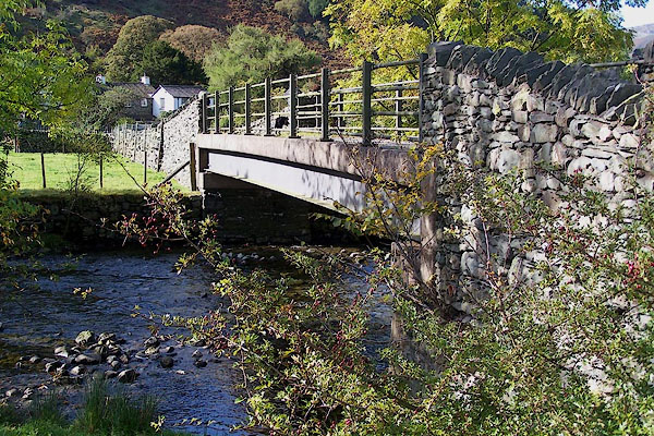 BOF74.jpg (taken 5.10.2007) |
||
|
|
||
| evidence:- | old map:- OS County Series (Cmd 70 14) placename:- Stonethwaite Bridge |
|
| source data:- | Maps, County Series maps of Great Britain, scales 6 and 25
inches to 1 mile, published by the Ordnance Survey, Southampton,
Hampshire, from about 1863 to 1948. |
|
|
|
||
| evidence:- | old print:- Green 1809 placename:- Stonethwaite Bridge |
|
| source data:- | Print, Stonethwaite Bridge, Borrowdale, Cumberland, drawn and engraved by William
Green, Ambleside, Westmorland, 1809.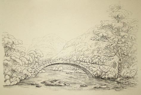 click to enlarge click to enlargePR1264.jpg A single span stone bridge spans a shallow rocky stream either bank of which is fringed with trees. Fells rise beyond. printed at bottom centre:- "STONETHWAITE BRIDGE. Published Ambleside. Augst 1st 1809 by W. Green." item:- Tullie House Museum : 1978.108.92.3 Image © Tullie House Museum |
|
|
|
||
| evidence:- | old print:- Green 1815 placename:- Stonethwaite Bridge |
|
| source data:- | Print, coloured aquatint, Stonethwaite Bridge, Stonethwaite, Borrowdale, Cumberland,
by William Green, Ambleside, Westmorland, 1815.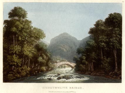 click to enlarge click to enlargeGN0542.jpg Plate 45 in Lake Scenery. printed at upper right:- "45" printed at bottom:- "STONETHWAITE BRIDGE. / Published at Ambleside, June 1, 1815, by Wm. Green." item:- Armitt Library : A6646.42 Image © see bottom of page |
|
|
|
||
| evidence:- | descriptive text:- Ford 1839 (3rd edn 1843) placename:- Stonethwaite Bridge |
|
| source data:- | Guide book, A Description of Scenery in the Lake District, by
Rev William Ford, published by Charles Thurnam, Carlisle, by W
Edwards, 12 Ave Maria Lane, Charles Tilt, Fleet Street, William
Smith, 113 Fleet Street, London, by Currie and Bowman,
Newcastle, by Bancks and Co, Manchester, by Oliver and Boyd,
Edinburgh, and by Sinclair, Dumfries, 1839. goto source goto sourcePage 68:- "..." "... Stonethwaite Bridge. This makes a picturesque subject, the village composing the middle ground, and the Hay Stacks the distance; ..." |
|
|
|
||
| evidence:- | old print:- Green 1809 placename:- Stonethwaite Bridge item:- eagle |
|
| source data:- | Print, soft ground etching, Stonethwaite Bridge, Borrowdale, Cumberland, by William
Green, published by William Green, Ambleside, Westmorland, and Longman, Hurst, Rees
and Orme, Paternoster Row, London, 1809.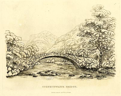 click to enlarge click to enlargeGN0343.jpg Plate 43 in Seventy Eight Studies from Nature. printed in introductory pages to set of prints:- "Number 43. The remote mountain in this view is Eagle Crag, ... The river spanned by Stonethwaite Bridge, is that branch of the Derwent which runs from the summit of the Stake; the division of Langdale and Borrowdale, and of Westmorland and Cumberland." printed at bottom:- "STONETHWAITE BRIDGE. / Published Ambleside, Augst. 1st. 1809, by W. Green." item:- Armitt Library : A6637.43 Image © see bottom of page |
|
|
|
||
Lakes Guides menu.