 |
 |
   |
|
|
|
|
|
Highlow Tarn |
| locality:- |
Tarn Hows |
| civil parish:- |
Coniston (formerly Lancashire) |
| civil parish:- |
Hawkshead (formerly Lancashire) |
| county:- |
Cumbria |
| locality type:- |
tarn |
| coordinates:- |
SD330999 |
| 1Km square:- |
SD3399 |
| 10Km square:- |
SD39 |
|
|
|

Click to enlarge
BVR58.jpg (taken 15.11.2011)
|
|
|
| evidence:- |
old map:- OS County Series (Lan 2 13)
placename:- Tarns, The
|
| source data:- |
Maps, County Series maps of Great Britain, scales 6 and 25
inches to 1 mile, published by the Ordnance Survey, Southampton,
Hampshire, from about 1863 to 1948.
|
|
|
| evidence:- |
old map:- OS County Series (Lan 2)
placename:- High Tarn
placename:- Middle Tarn
placename:- Low Tarn
|
| source data:- |
Maps, County Series maps of Great Britain, scales 6 and 25
inches to 1 mile, published by the Ordnance Survey, Southampton,
Hampshire, from about 1863 to 1948.
Three tarns are shown:- "High Tarn"
"Middle Tarn"
"Low Tarn"
|
|
|
| evidence:- |
old map:- Otley 1818
|
| source data:- |
Map, uncoloured engraving, The District of the Lakes,
Cumberland, Westmorland, and Lancashire, scale about 4 miles to
1 inch, by Jonathan Otley, 1818, engraved by J and G Menzies,
Edinburgh, Scotland, published by Jonathan Otley, Keswick,
Cumberland, et al, 1833.
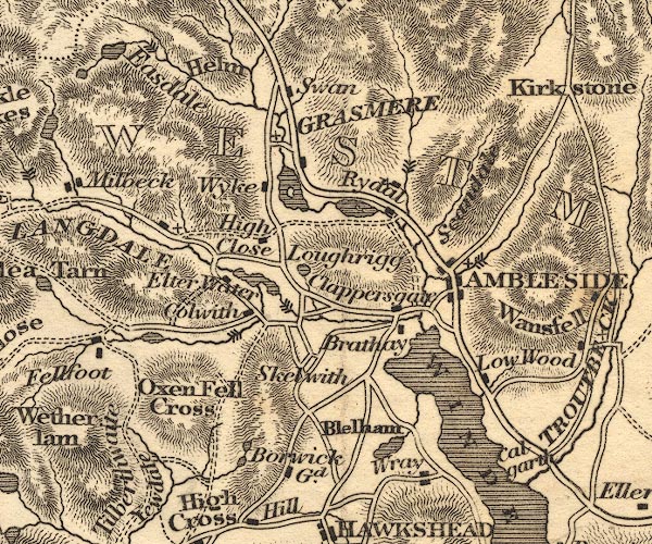
OT02NY30.jpg
Two tarns are drawn.
item:- JandMN : 48.1
Image © see bottom of page
|
|
|
| evidence:- |
descriptive text:- Otley 1823 (5th edn 1834)
item:- geology
|
| source data:- |
Guide book, A Concise Description of the English Lakes, the
mountains in their vicinity, and the roads by which they may be
visited, with remarks on the mineralogy and geology of the
district, by Jonathan Otley, published by the author, Keswick,
Cumberland now Cumbria, by J Richardson, London, and by Arthur
Foster, Kirkby Lonsdale, Cumbria, 1823; published 1823-49,
latterly as the Descriptive Guide to the English Lakes.
 goto source goto source
Page 36:- "Two or three pools, between the hills on the north of Coniston Waterhead, are called
simply the Tarns; ..."
"..."
 goto source goto source
Page 158:- "The THIRD division - forming only inferior elevations - commences with a bed of dark-blue
or blackish transition limestone, containing here and there a few shells and madrepores,
and alternating with a slaty rock of the same colour; the different layers of each
being in some places several feet, in others only a few inches in thickness. This
limestone crosses the river Duddon near Broughton; passing Broughton Mills it runs
in a north-east direction through Torver, by the foot of the Old Man mountain, and
appears near Low Yewdale and Yew Tree. Here it makes a considerable slip to the eastward,
after which it ranges past the Tarns upon the hills above Borwick Ground; and stretching
through Skelwith, it crosses the head of Windermere near Low Wood Inn. Then passing
above Dovenest and Skelgill, it traverses the vales of Troutbeck, Kentmere, and Long
Sleddale;"
|
|
|
| evidence:- |
old photograph:- Bell 1880s-1940s
|
| source data:- |
Photograph, black and white, The Tarns, Tarn Hows, Coniston and Hawkshead, Lancashire,
by Herbert Bell, photographer, Ambleside, Westmorland, 1890s.
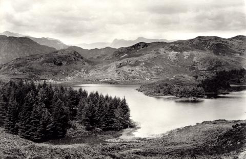 click to enlarge click to enlarge
HB0908.jpg
stamped at reverse:- "HERBERT BELL / Photographer / AMBLESIDE"
item:- Armitt Library : ALPS583
Image © see bottom of page
|
|
|
| evidence:- |
old photograph:- Bell 1880s-1940s
|
| source data:- |
Photograph, sepia, The Tarns, Tarn Hows, Coniston and Hawkshead, Lancashire, by Herbert
Bell, photographer, Ambleside, Westmorland, 1890s.
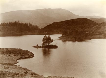 click to enlarge click to enlarge
HB0721.jpg
item:- Armitt Library : ALPS385
Image © see bottom of page
|
|
|
| evidence:- |
old photograph:- Bell 1880s-1940s
|
| source data:- |
Photograph, sepia, The Tarns, Tarn Hows, Coniston and Hawkshead, Lancashire, by Herbert
Bell, photographer, Ambleside, Westmorland, 1890s.
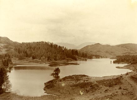 click to enlarge click to enlarge
HB0597.jpg
item:- Armitt Library : ALPS257
Image © see bottom of page
|
|
|
| evidence:- |
old photograph:- Bell 1880s-1940s
|
| source data:- |
Photograph, sepia, Tarns at Tarn Hows, Coniston, Cumberland etc, by Herbert Bell,
Ambleside, Westmorland, 1890s?
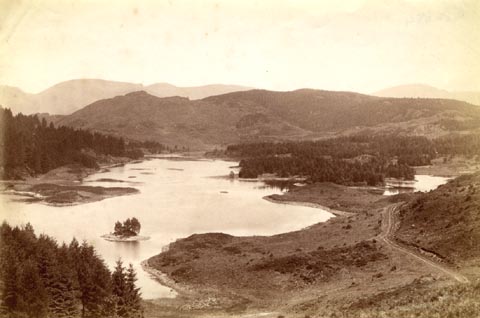 click to enlarge click to enlarge
HB0325.jpg
item:- Armitt Library : ALPS684
Image © see bottom of page
|
|
|
| evidence:- |
old photograph:- Bell 1880s-1940s
|
| source data:- |
Photograph, black and white, The Tarns, Tarn Hows, Coniston and Hawkshead, Lancashire,
by Herbert Bell, photographer, Ambleside, Westmorland, 1890s.
 click to enlarge click to enlarge
HB0908.jpg
stamped at reverse:- "HERBERT BELL / Photographer / AMBLESIDE"
item:- Armitt Library : ALPS583
Image © see bottom of page
|
|
|
| evidence:- |
old photograph:- Bell 1880s-1940s
|
| source data:- |
Photograph, sepia, The Tarns, Tarn Hows, Coniston and Hawkshead, Lancashire, by Herbert
Bell, photographer, Ambleside, Westmorland, 1890s.
 click to enlarge click to enlarge
HB0721.jpg
item:- Armitt Library : ALPS385
Image © see bottom of page
|
|
|
| evidence:- |
old photograph:- Bell 1880s-1940s
|
| source data:- |
Photograph, sepia, The Tarns, Tarn Hows, Coniston and Hawkshead, Lancashire, by Herbert
Bell, photographer, Ambleside, Westmorland, 1890s.
 click to enlarge click to enlarge
HB0597.jpg
item:- Armitt Library : ALPS257
Image © see bottom of page
|
|
|
| evidence:- |
old photograph:- Bell 1880s-1940s
|
| source data:- |
Photograph, sepia, Tarns at Tarn Hows, Coniston, Cumberland etc, by Herbert Bell,
Ambleside, Westmorland, 1890s?
 click to enlarge click to enlarge
HB0325.jpg
item:- Armitt Library : ALPS684
Image © see bottom of page
|
|
|
| evidence:- |
old print:- Pearson 1900s
placename:- Tarn Hows
|
| source data:- |
Print, halftone photograph, Tarn Hows, Coniston, Lancashire, published by C Arthur
Pearson, Henrietta Street, London, 1900s.
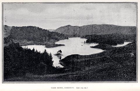 click to enlarge click to enlarge
PS1E37.jpg
On p.96 of Pearson's Gossipy Guide to the English Lakes and Neighbouring Districts.
printed at bottom:- "TARN HOWS, CONISTON. (pp.94, 95.)"
item:- Armitt Library : A1188.44
Image © see bottom of page
|
|
|
| evidence:- |
old print:- Pearson 1900s
placename:- Tarn Hows
|
| source data:- |
Print, halftone photograph, Tarn Hows, Coniston, Lancashire, published by C Arthur
Pearson, Henrietta Street, London, 1900s.
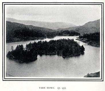 click to enlarge click to enlarge
PS1E40.jpg
On p.104 of Pearson's Gossipy Guide to the English Lakes and Neighbouring Districts.
printed at bottom:- "TARN HOWS. (p.95)."
item:- Armitt Library : A1188.47
Image © see bottom of page
|
|
|
hearsay:-
|
The lakes were created as a designed landscape by the Marshall Family in the 1860s.
A small dam was built which caused the three tarns to become one. The site was bought
by Beatrix Potter in the 1930s, and is now owned by the National Trust.
|
|
|


 goto source
 goto source
 click to enlarge
 click to enlarge
 click to enlarge
 click to enlarge
 click to enlarge
 click to enlarge
 click to enlarge
 click to enlarge
 click to enlarge
 click to enlarge