 Old Cumbria Gazetteer
 |
 |
|
| Eskdale | ||
| Eshd'l | ||
| Eshdel | ||
| site name:- | Esk, River (2) | |
| civil parish:- | Eskdale (formerly Cumberland) | |
| county:- | Cumbria | |
| locality type:- | valley | |
| locality type:- | locality | |
| coordinates:- | NY18130029 (etc etc) | |
| 1Km square:- | NY1800 | |
| 10Km square:- | NY10 | |
| 10Km square:- | SD19 | |
|
|
||
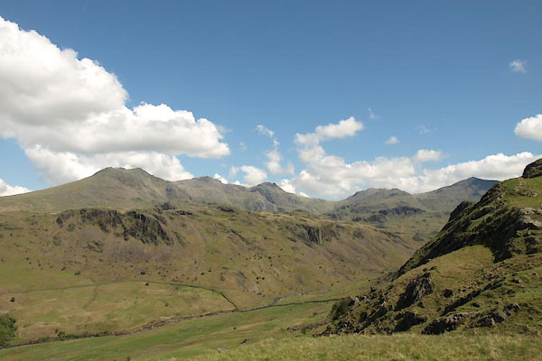 BYL71.jpg From Hardknott roman fort. (taken 4.6.2013) 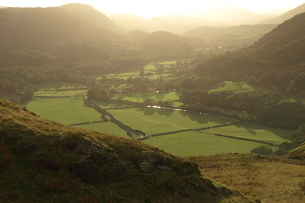 BVM43.jpg (taken 7.10.2010) |
||
|
|
||
| evidence:- | old map:- Saxton 1579 placename:- Eskedale |
|
| source data:- | Map, hand coloured engraving, Westmorlandiae et Cumberlandiae Comitatus ie Westmorland
and Cumberland, scale about 5 miles to 1 inch, by Christopher Saxton, London, engraved
by Augustinus Ryther, 1576, published 1579-1645.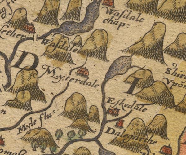 Sax9NY10.jpg Church, symbol for a parish or village, with a parish church. "Eskedale" item:- private collection : 2 Image © see bottom of page |
|
|
|
||
| evidence:- | old map:- Mercator 1595 (edn?) placename:- Eskedale |
|
| source data:- | Map, hand coloured engraving, Northumbria, Cumberlandia, et
Dunelmensis Episcopatus, ie Northumberland, Cumberland and
Durham etc, scale about 6.5 miles to 1 inch, by Gerard Mercator,
Duisberg, Germany, about 1595. MER8CumE.jpg "Eskedale" circle item:- JandMN : 169 Image © see bottom of page |
|
|
|
||
| evidence:- | old map:- Speed 1611 (Cmd) placename:- Eskdale |
|
| source data:- | Map, hand coloured engraving, Cumberland and the Ancient Citie
Carlile Described, scale about 4 miles to 1 inch, by John Speed,
1610, published by J Sudbury and George Humble, Popes Head
Alley, London, 1611-12.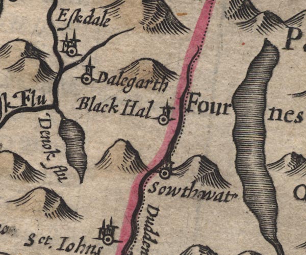 SP11SD29.jpg "Eskdale" circle, building, tower item:- private collection : 16 Image © see bottom of page |
|
|
|
||
| evidence:- | old map:- Drayton 1612/1622 placename:- Eskedale |
|
| source data:- | Map, hand coloured engraving, Cumberlande and Westmorlande, by
Michael Drayton, probably engraved by William Hole, scale about
4 or 5 miles to 1 inch, published by John Mariott, John
Grismand, and Thomas Dewe, London, 1622.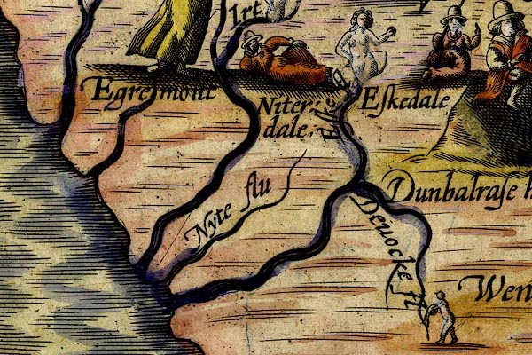 DRY521.jpg "Eskedale" Lady sitting. item:- JandMN : 168 Image © see bottom of page |
|
|
|
||
| evidence:- | table of distances:- Simons 1635 placename:- Eskedale |
|
| source data:- | Table of distances, uncoloured engraving, Cumberland, with a
thumbnail map, scale about 41 miles to 1 inch, by Mathew Simons,
published in A Direction for the English Traviller, 1635.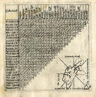 click to enlarge click to enlargeSIM4.jpg "Eskedale S" and tabulated distances item:- private collection : 50.11 Image © see bottom of page |
|
|
|
||
| evidence:- | old map:- Seller 1694 (Cmd) placename:- Eskdale |
|
| source data:- | Map, uncoloured engraving, Cumberland, scale about 12 miles to 1
inch, by John Seller, 1694. click to enlarge click to enlargeSEL9.jpg "Eskdale" circle, italic lowercase text; settlement or house item:- Dove Cottage : 2007.38.89 Image © see bottom of page |
|
|
|
||
| evidence:- | old map:- Badeslade 1742 placename:- Eskdale |
|
| source data:- | Map, uncoloured engraving, A Map of Cumberland North from
London, scale about 11 miles to 1 inch, with descriptive text,
by Thomas Badeslade, London, engraved and published by William
Henry Toms, Union Court, Holborn, London, 1742. click to enlarge click to enlargeBD10.jpg "Eskdale" circle, italic lowercase text; village, hamlet or locality item:- JandMN : 115 Image © see bottom of page |
|
|
|
||
| evidence:- | old map:- Bowen and Kitchin 1760 placename:- Eskdale |
|
| source data:- | Map, hand coloured engraving, A New Map of the Counties of
Cumberland and Westmoreland Divided into their Respective Wards,
scale about 4 miles to 1 inch, by Emanuel Bowen and Thomas
Kitchin et al, published by T Bowles, Robert Sayer, and John
Bowles, London, 1760.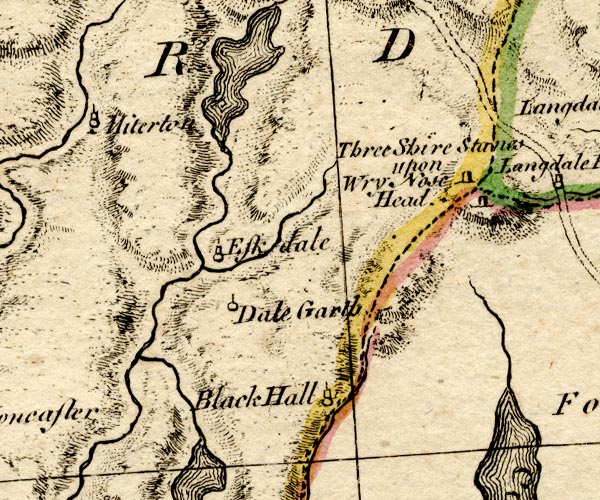 BO18SD19.jpg "Eskdale" circle, tower item:- Armitt Library : 2008.14.10 Image © see bottom of page |
|
|
|
||
| evidence:- | old map:- Donald 1774 (Cmd) placename:- Eskdale |
|
| source data:- | Map, hand coloured engraving, 3x2 sheets, The County of Cumberland, scale about 1
inch to 1 mile, by Thomas Donald, engraved and published by Joseph Hodskinson, 29
Arundel Street, Strand, London, 1774.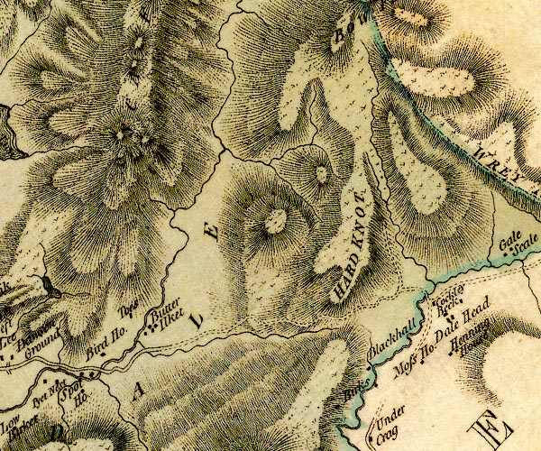 D4NY20SW.jpg  D4SD19NE.jpg "ESKDALE" valley, between hachures item:- Carlisle Library : Map 2 Images © Carlisle Library |
|
|
|
||
| evidence:- | old map:- West 1784 map placename:- Eskdale |
|
| source data:- | Map, hand coloured engraving, A Map of the Lakes in Cumberland,
Westmorland and Lancashire, scale about 3.5 miles to 1 inch,
engraved by Paas, 53 Holborn, London, about 1784. Ws02SD19.jpg item:- Armitt Library : A1221.1 Image © see bottom of page |
|
|
|
||
| evidence:- | old map:- Cooke 1802 placename:- Eskdale |
|
| source data:- | Map, The Lakes, Westmorland and Cumberland, scale about 8.5
miles to 1 inch, engravedby Neele and Son, published by
Sherwood, Jones and Co, Paternoster Road, London, 1824. click to enlarge click to enlargeGRA1Lk.jpg "Eskdale" blocks, italic lowercase text, village, hamlet, locality item:- Hampshire Museums : FA2000.62.5 Image © see bottom of page |
|
|
|
||
| evidence:- | old map:- Cooper 1808 placename:- Eskdale |
|
| source data:- | Map, uncoloured engraving, Cumberland, scale about 10.5 miles to
1 inch, drawn and engraved by Cooper, published by R Phillips,
Bridge Street, Blackfriars, London, 1808. click to enlarge click to enlargeCOP3.jpg "Eskdale" circle; village or hamlet item:- JandMN : 86 Image © see bottom of page |
|
|
|
||
| evidence:- | old print with text:- Farington 1816 placename:- Eskdale |
|
| source data:- | Print, uncoloured engraving and descriptive text, Muncaster Castle and Eskdale, Cumberland,
drawn by Joseph Farington, engraved by John Pye, published by T Cadell and W Davies,
Strand, London, 1815.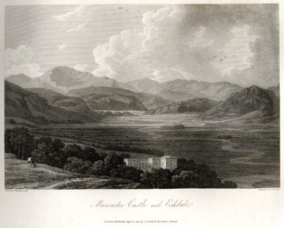 click to enlarge click to enlargeFA0408.jpg printed, bottom left, right, centre "Drawn by J. Farington R.A. / Engraved by John Pye. / Muncaster Castle and Eskdale. / London Published Septr. 15, 1815, by T. Cadell &W. Davies, Strand." Descriptive text:- "VIEW OF MUNCASTER CASTLE." "... Muncaster Castle, ... stands on an eminence, nearly surrounded by beautiful plantations, and commanding in front a fine view of the Vale of Esk, flanked on each side, and terminated in front, by the wildest mountain scenery. ..." "The River Esk, which gives its name to Esk-dale, is formed by some small streams which rise near Bow-fell; it falls into the sea at Ravenglass, after a course of about thirteen miles." item:- Armitt Library : A6666.8 Image © see bottom of page |
|
|
|
||
| evidence:- | old map:- Otley 1818 placename:- Eskdale |
|
| source data:- | Map, uncoloured engraving, The District of the Lakes,
Cumberland, Westmorland, and Lancashire, scale about 4 miles to
1 inch, by Jonathan Otley, 1818, engraved by J and G Menzies,
Edinburgh, Scotland, published by Jonathan Otley, Keswick,
Cumberland, et al, 1833. OT02NY10.jpg "ESKDALE" item:- JandMN : 48.1 Image © see bottom of page |
|
|
|
||
| evidence:- | descriptive text:- Otley 1823 (5th edn 1834) item:- geology |
|
| source data:- | Guide book, A Concise Description of the English Lakes, the
mountains in their vicinity, and the roads by which they may be
visited, with remarks on the mineralogy and geology of the
district, by Jonathan Otley, published by the author, Keswick,
Cumberland now Cumbria, by J Richardson, London, and by Arthur
Foster, Kirkby Lonsdale, Cumbria, 1823; published 1823-49,
latterly as the Descriptive Guide to the English Lakes. goto source goto sourcePage 155:- "The SECOND division [of slate rocks] comprehends the mountains of Eskdale, Wasdale, Ennerdale, Borrowdale, Langdale, Grasmere, Patterdale, Martindale, Mardale, and some adjacent places; including the two highest mountains of the district, Scawfell and Helvellyn, as well as the Old Man at Coniston. All our fine towering crags belong to it; and most of the cascades among the lakes fall over it. There are indeed some lofty precipices in the former division; ..." "..." |
|
|
|
||
| evidence:- | descriptive text:- Ford 1839 (3rd edn 1843) placename:- Eskdale placename:- Eshdale |
|
| source data:- | Guide book, A Description of Scenery in the Lake District, by
Rev William Ford, published by Charles Thurnam, Carlisle, by W
Edwards, 12 Ave Maria Lane, Charles Tilt, Fleet Street, William
Smith, 113 Fleet Street, London, by Currie and Bowman,
Newcastle, by Bancks and Co, Manchester, by Oliver and Boyd,
Edinburgh, and by Sinclair, Dumfries, 1839. goto source Page 13:- "... A mountain track from Goldrill Crag leads to" "ESKDALE," "(Vulgarly Eshdale,) and the first object of interest is Birker Force, perhaps the finest cascade in Cumberland; ... On the same side of the hill, but lower down in the valley, is Stanley Gill, ... The stream of this vale passes under the woody steeps, on which stands Muncaster Castle, ..." |
|
|
|
||
| evidence:- | old map:- Garnett 1850s-60s H placename:- Eskdale |
|
| source data:- | Map of the English Lakes, in Cumberland, Westmorland and
Lancashire, scale about 3.5 miles to 1 inch, published by John
Garnett, Windermere, Westmorland, 1850s-60s.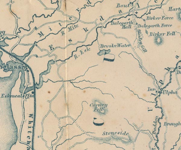 GAR2SD19.jpg "Eskdale" river valley item:- JandMN : 82.1 Image © see bottom of page |
|
|
|
||
 Martineau Directory 1855 Martineau Directory 1855 |
||
|
|
||
| evidence:- | old photograph:- Bell 1880s-1940s |
|
| source data:- | Photograph, sepia, Eskdale, Cumberland, by Herbert Bell, Ambleside, Westmorland, 1890s.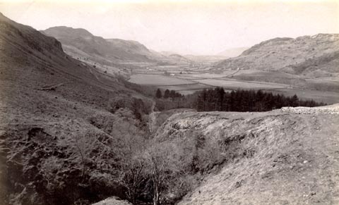 click to enlarge click to enlargeHB0525.jpg item:- Armitt Library : ALPS188 Image © see bottom of page |
|
|
|
||
| evidence:- | old print:- Bradley 1901 placename:- Eskdale |
|
| source data:- | Print, uncoloured lithograph, Eskdale, Cumberland, by Joseph Pennell, published by
Macmillan and Co, London, 1901.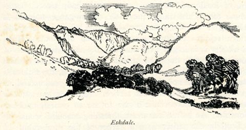 click to enlarge click to enlargeBRL144.jpg On page 185 of Highways and Byways in the Lake District, by A G Bradley. printed at bottom:- "Eskdale." item:- JandMN : 464.44 Image © see bottom of page |
|
|
|
||
| evidence:- | old print:- Bradley 1901 |
|
| source data:- | Print, uncoloured lithograph, Near Boot, Eskdale, Cumberland, by Joseph Pennell, published
by Macmillan and Co, London, 1901.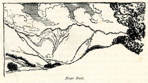 click to enlarge click to enlargeBRL145.jpg On page 188 of Highways and Byways in the Lake District, by A G Bradley. printed at bottom:- "Near Boot." item:- JandMN : 464.45 Image © see bottom of page |
|
|
|
||
| evidence:- | old print:- Heaton Cooper 1905 (edn 1908) placename:- Eskdale item:- fox hunt; fox hounds |
|
| source data:- | Print, colour halftone, A Fell Fox Hunt, Head of Eskdale and Scawfell, Eskdale, Cumberland,
from a watercolour painting by Alfred Heaton Cooper, published by Adam and Charles
Black, London, 2nd edn 1908.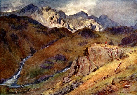 click to enlarge click to enlargeHC0129.jpg Opposite p.80 of The English Lakes, painted by Alfred Heaton Cooper, described by William T Palmer. printed at tissue opposite the print:- "A FELL FOX-HUNT, HEAD OF ESKDALE AND SCAWFELL" printed at signed lower right:- "[A HEATON COOPER]" item:- JandMN : 468.29 Image © see bottom of page |
|
|
|
||
| evidence:- | old photograph:- Marr 1916 placename:- Eskdale |
|
| source data:- | Photograph, halftone print, Hanging Valley, near Head of Eskdale, Cumberland, 1916.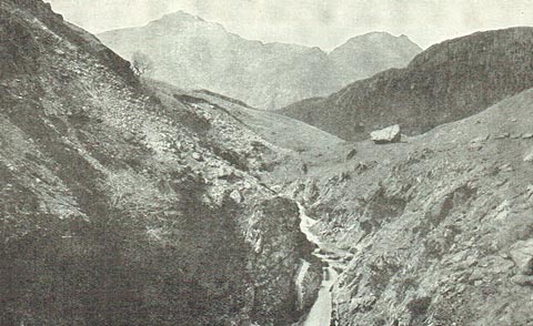 click to enlarge click to enlargeMA1220.jpg item:- JandMN : 173.28 Image © see bottom of page |
|
|
|
||
| evidence:- | old photograph:- Seascale 1920s-30s placename:- Eskdale |
|
| source data:- | Photograph, halftone, Eskdale, Cumberland, by Alfred Pettitt, Keswick, in a guide
book, Seascale for Health and Holidays, published by Edward Burrow and Son, Cheltenham,
Gloucestershire, 1920s-30s.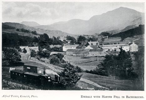 click to enlarge click to enlargeSES104.jpg item:- JandMN : 1079.4 Image © see bottom of page |
|
|
|
||
| evidence:- | old photograph:- Bogg 1898 |
|
| source data:- | Photograph, halftone print, A Mountain Stream, Eskdale, Cumberland, by G H Rodwell,
published by Edmund Bogg, 3 Woodhouse Lane, and James Miles, Guildford Street, Leeds,
Yorkshire, 1898.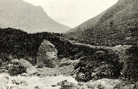 click to enlarge click to enlargeBGG180.jpg Included on p.209 of Lakeland and Ribblesdale, by Edmund Bogg. item:- JandMN : 231.80 Image © see bottom of page |
|
|
|
||
| evidence:- | outline view:- Jenkinson 1875 placename:- Eskdale |
|
| source data:- | Print, lithograph, outline view, Panoramic Sketches from Scawfell Pike, Cumberland,
by Edwin A Pettitt, London, published by Edward Stanford, 55 Charing Cross, London,
1875. click to enlarge click to enlargeJk01E3.jpg "... Upper Eskdale ..." item:- JandMN : 28.9 Image © see bottom of page |
|
|
|
||
| evidence:- | old drawing:- Brockbank 1870s placename:- Eskdale |
|
| source data:- | Drawing, ink, mammilated rocks, roche moutonnee? Eskdale, Cumberland, 1871-72? used
by William Brockbank.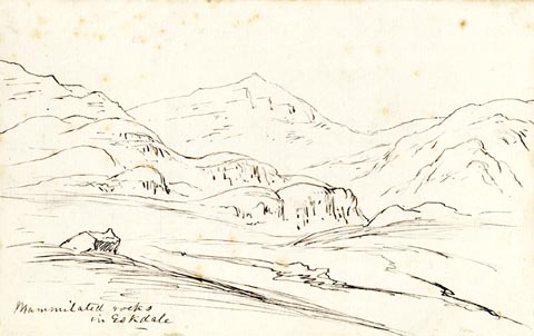 click to enlarge click to enlargePR1911.jpg "Mammilated rocks / in Eskdale" "Eskdale / W. Brockbank F.G.S / 6" item:- Armitt Library : 1959.68.6 Image © see bottom of page |
|
|
|
||
| evidence:- | old print with text:- Farington 1816 (plate 26) placename:- Vale of Esk |
|
| source data:- | Print, uncoloured engraving, Muncaster Castle and Eskdale, drawn by Joseph Farington,
engraved by John Pye, published by T Cadell and W Davies, Strand, London, 1815.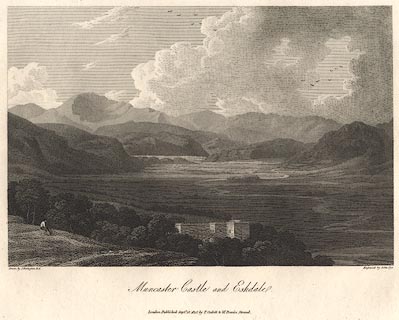 click to enlarge click to enlargeBNV38.jpg Plate 26 in The Lakes of Lancashire, Westmorland and Cumberland ... with text by Thomas Hartwell Horne:- "[Muncaster Castle] stands on an eminence, ... commanding in front a fine view of the Vale of Esk, flanked on each side, and terminated in front, by the wildest mountain scenery. ..." item:- private collection : 75 Image © see bottom of page |
|
|
|
||
 BTO15.jpg From the top of Hardknot Pass. (taken 24.9.2010)  BRM61.jpg Upper part of the valley. (taken 14.9.2009) 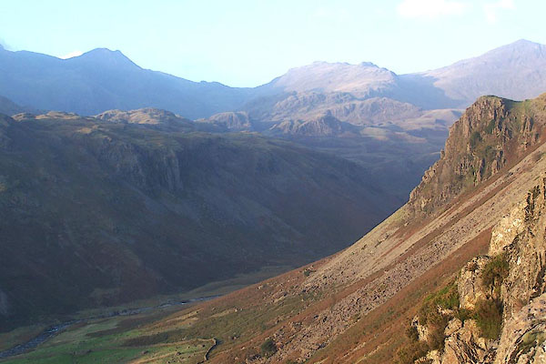 BMW36.jpg From near the roman fort at Hardknot. (taken 13.10.2006) 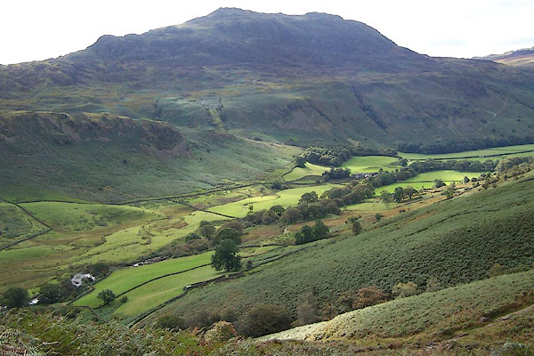 BRM35.jpg with Brotherilkeld in the mid ground. (taken 14.9.2009) 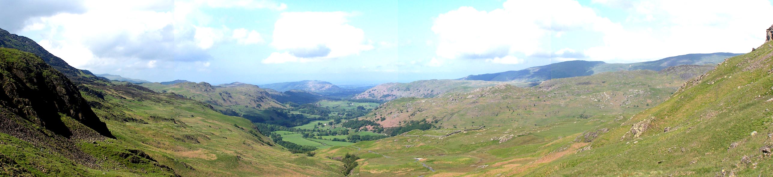 Click to enlarge BNT84.jpg From the top of Hardknot Pass. (taken 5.6.2007) 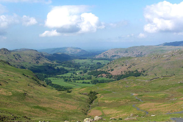 BNT83.jpg From the top of Hardknot Pass. (taken 5.6.2007) 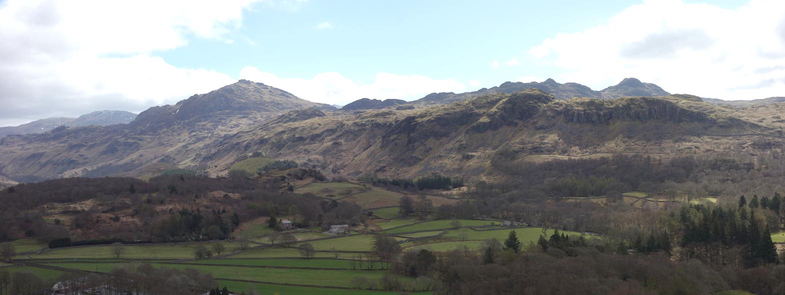 Click to enlarge BYG09.jpg Across Eskdale to Harter Fell and Ulpha Fell. (taken 27.4.2013) |
||
|
|
||
Lakes Guides menu.