 Old Cumbria Gazetteer
 |
 |
|
| Burthwaite Wood, Bassenthwaite | ||
| Burthwaite Wood | ||
| locality:- | Burthwaite | |
| civil parish:- | Bassenthwaite (formerly Cumberland) | |
| county:- | Cumbria | |
| locality type:- | wood | |
| coordinates:- | NY21333328 (etc) | |
| 1Km square:- | NY2133 | |
| 10Km square:- | NY23 | |
|
|
||
| evidence:- | old map:- Ogilby 1675 (plate 96) placename:- Birthut Wood |
|
| source data:- | Road strip map, hand coloured engraving, the Road from Kendal to
Cockermouth, and the Road from Egremond to Carlisle, scale about
1 inch to 1 mile, by John Ogilby, London, 1675.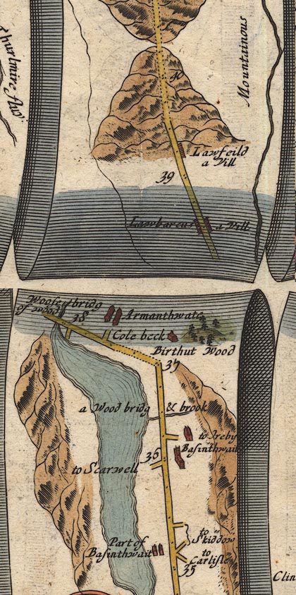 OG96m035.jpg In mile 37, Cumberland. "Birthut Wood" trees on a hill to the right of the road. item:- JandMN : 22 Image © see bottom of page |
|
|
|
||
| evidence:- | probably old map:- Bowen 1720 (plate 260) placename:- Birthut Wood |
|
| source data:- | Road strip map, uncoloured engraving, pl.260, The Road from
Kendal to Cockermouth, scale about 2 miles to 1 inch, with
sections in Westmorland and Cumberland, published by Emanuel
Bowen, St Katherines, London, 1720.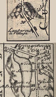 B260m35.jpg At mile 36-37. item:- private collection : 1.260 Image © see bottom of page |
|
|
|
||
 Lakes Guides menu.