 Old Cumbria Gazetteer
 |
 |
|
| Woundale, Lakes | ||
| Woundale | ||
| civil parish:- | Lakes (formerly Westmorland) | |
| county:- | Cumbria | |
| locality type:- | valley | |
| coordinates:- | NY41080745 (etc) | |
| 1Km square:- | NY4107 | |
| 10Km square:- | NY40 | |
|
|
||
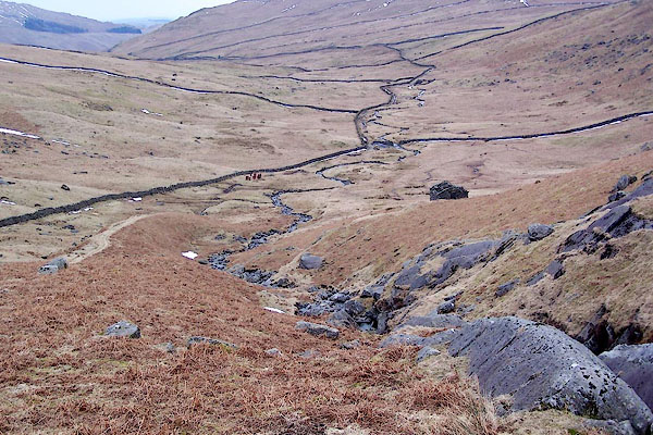 BSG08.jpg (taken 9.3.2010) |
||
|
|
||
| evidence:- | old map:- OS County Series (Wmd 19 15) placename:- Woundale |
|
| source data:- | Maps, County Series maps of Great Britain, scales 6 and 25
inches to 1 mile, published by the Ordnance Survey, Southampton,
Hampshire, from about 1863 to 1948. OS County Series (Wmd 19 16) |
|
|
|
||
| evidence:- | old text:- Clarke 1787 placename:- Woundale item:- cairn |
|
| source data:- | Guide book, A Survey of the Lakes of Cumberland, Westmorland,
and Lancashire, written and published by James Clarke, Penrith,
Cumberland, and in London etc, 1787; published 1787-93. goto source goto sourcePage 153:- "... Before we come to the top of Kirkstone, we see on the right hand, at a small distance, several cairns, one of them remarkably large, but upon what occasion they were raised we have no tradition; the place where they are situated is called Woundale, but what is the signification or derivation of that name I am unable to determine. ..." |
|
|
|
||
| evidence:- | outline view:- Otley 1823 (8th edn 1849) placename:- Woundal Head |
|
| source data:- | Engraving, outline view of mountains, Windermere looking towards the North East from
Bowness, drawn by T Binns, engraved by O Jewitt, opposite p.2 of A Descriptive Guide
of the English Lakes, by Jonathan Otley, 8th edition, 1849.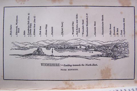 click to enlarge click to enlargeO80E02.jpg With a list of mountains. item:- Armitt Library : A1180.3 Image © see bottom of page |
|
|
|
||
Lakes Guides menu.