 Old Cumbria Gazetteer
 |
 |
|
| included in:- |
 Coniston Water Coniston Water |
|
| viewpoint, Water Park | ||
| site name:- | Water Park | |
| civil parish:- | Colton (formerly Lancashire) | |
| county:- | Cumbria | |
| locality type:- | viewpoint | |
| coordinates:- | SD29319028 (about) | |
| 1Km square:- | SD2990 | |
| 10Km square:- | SD29 | |
|
|
||
| evidence:- | descriptive text:- West 1778 (11th edn 1821) placename:- station, Coniston, West 1 |
|
| source data:- | Guide book, A Guide to the Lakes, by Thomas West, published by
William Pennington, Kendal, Cumbria once Westmorland, and in
London, 1778 to 1821. goto source Page 47:- "..." "STATION I. - A little above the village of Nibthwaite, the lake opens in full view. From the rock, on the left of the road, you have a general prospect of the lake, upwards." goto sourcePage 48:- "This station is found by observing where you have a hanging rock over the road on the east, and an ash tree on the west side of the road. On the opposite shore, to the left, and close by the water's edge, are some stripes of meadow and green ground, cut into small inclosures, with some dark-coloured houses under aged yew trees. Two promontories project a great way into the lake; the broadest is finely terminated by steep rocks, and crowned with wood; and both are insulated when the lake is high. Upwards, over a fine sheet of water, the lake is again intersected by a far-projecting promontory, that swells into two eminences, and betwixt them the lake is again caught, with some white houses at the feet of the mountains. And more to the right, over another headland, you catch a fourth view of the lake, twisting to the north east. Almost opposite to this station, stands a house on the crown of a rock, covered with ancient trees, that has a most romantic appearance." "The noble scenery increases as you ride along the banks. In some places, bold rocks (lately covered with wood) conceal the lake entirely, and when the winds blow, the beating of surges is heard just under you. In other places, abrupt openings show the lake a-new, and there, when calm, its limpid sur-" goto sourcePage 49:- "[sur]face, shining like a crystal mirror reflects the azure sky, or its dappled clouds, in the finest mixture of nature's clare-obscure. On the western side, the shore is more variegated with small inclosures, scattered cots, groves and meadows." |
|
|
|
||
| evidence:- | old map:- Crosthwaite 1783-94 (Con) |
|
| source data:- | Map, uncoloured engraving, An Accurate Map of Coniston Lake,
scale about 3 inches to 1 mile, by Peter Crosthwaite, Keswick,
Cumberland, 1788, version published 1809.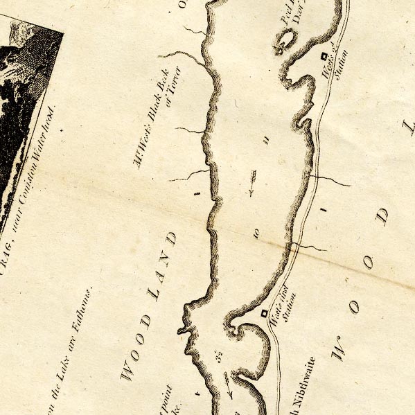 CTESD29V.jpg "West's first Station" square symbol item:- JandMN : 182.5 Image © see bottom of page |
|
|
|
||
| evidence:- | old map:- Crosthwaite 1783-94 (Con) placename:- station, Coniston, West 1 |
|
| source data:- | Series of maps, An Accurate Map of the Matchless Lake of
Derwent, of the Grand Lake of Windermere, of the Beautiful Lake
of Ullswater, of Broadwater or Bassenthwaite Lake, of Coniston
Lake, of Buttermere, Crummock and Loweswater Lakes, and
Pocklington's Island, by Peter Crosthwaite, Kendal, Cumberland
now Cumbria, 1783 to 1794. "West's first Station" half a mile north of High Nibthwaite. |
|
|
|
||
| indexing | ||
| person:- | author : West, Thomas |
|
| place:- | Coniston Water | |
| date:- | 1778 |
|
| period:- | 18th century, late | |
| period:- | 1780s | |
| item:- | guide book; Guide to the Lakes |
|
|
|
||
Lakes Guides menu.