 Old Cumbria Gazetteer
 |
 |
|
| viewpoint, Loughrigg Fell | ||
| site name:- | Loughrigg Fell | |
| civil parish:- | Lakes (formerly Westmorland) | |
| county:- | Cumbria | |
| locality type:- | viewpoint | |
| coordinates:- | NY342057 (about) | |
| 1Km square:- | NY3405 | |
| 10Km square:- | NY30 | |
|
|
||
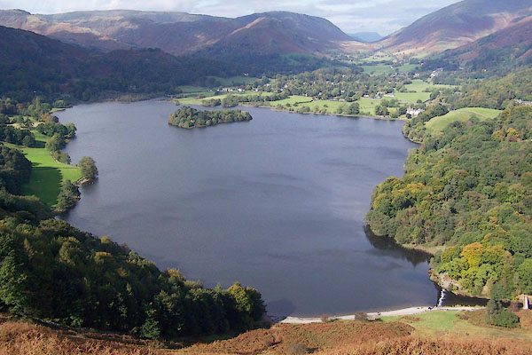 BPS41.jpg Grasmere from Loughrigg Terrace. (taken 6.10.2008) |
||
|
|
||
| evidence:- | descriptive text:- West 1778 (11th edn 1821) |
|
| source data:- | Guide book, A Guide to the Lakes, by Thomas West, published by
William Pennington, Kendal, Cumbria once Westmorland, and in
London, 1778 to 1821. goto source goto sourcePage 82:- "to Clappersgate, and along the banks of the river Brathay, and at Scalewith-bridge ascend a steep hill called Loughrig, that leads to Grasmere, and a little behind its summit you come into sight of the valley and lake, lying in the sweetest order. Observe a few steps leading to a soft green knoll, and from its crown you have the finest view of the vale, the lake, and the environs. The island is near the centre, unless the water be very low. Its margin is graced with a few scattered trees, and an embowered hut. The church stands at a small distance from the lake [Grasmere], on the side of the Rothay, its principal feeder. On each hand spread cultivated tracts, up the steep sides of the surrounding mountains, guarded by Steel-fell and Seat-sandle, which, advancing towards each other, close the view at Dunmail-raise. The broken head of Helm-crag has a fine effect, seen from this point." |
|
|
|
||
| evidence:- | descriptive text:- Otley 1823 (5th edn 1834) |
|
| source data:- | Guide book, A Concise Description of the English Lakes, the
mountains in their vicinity, and the roads by which they may be
visited, with remarks on the mineralogy and geology of the
district, by Jonathan Otley, published by the author, Keswick,
Cumberland now Cumbria, by J Richardson, London, and by Arthur
Foster, Kirkby Lonsdale, Cumbria, 1823; published 1823-49,
latterly as the Descriptive Guide to the English Lakes. goto source Page 77:- "[stands high] enough to command a view of the circumjacent vallies; and not so lofty as to lessen the importance of the surrounding mountains. Every rocky knoll presents a new combination of scenery. Windermere, a fine expanse of water with its ornamented banks; the town of Hawkshead and its environs, with Blelham Tarn, and the irregularly shaped Esthwaite Water; Loughrigg with its tarn, and Langdale with Elterwater; the beautiful vales of Grasmere and Rydal, with their two lakes, and the town and highly embellished neighbourhood of Ambleside; are the lowland objects. The circumscribing mountains of Coniston, Langdale, Grasmere, Rydal, Ambleside, and Troutbeck, are at such eligible distances that not only their elegantly formed outlines, but also their varied surface of rock and verdure, can clearly be distinguished. A small piece of Coniston Water, and the like of Thirlmere, are just sufficient to shew the place of those two lakes. The mountain Skiddaw seen over Dunmail Raise, and the top of Ingleborough in the direction of the Low Wood Inn, are extraneous objects beyond the common bounds of the panorama." "..." goto sourcePage 105:- "AMBLESIDE TO LOUGHRIGG FELL, AND LOUGHRIGG TARN." "It is a pleasant stroll for a pedestrian through the fields to Miller Bridge, from whence a path leads over the lower part of the Fell. After reaching the open common, a tourist of taste will not be confined to the path, but, by rambling from knoll to knoll, will obtain a most pleasing variety of prospects; and on reaching the top of Ivy Crag, a" goto sourcePage 106:- "large rock overlooking Loughrigg Tarn, he will have an instantaneous burst upon a most extraordinary assemblage of landscape beauties. Returning from the top of the rock, and proceeding by the path, he will soon perceive Loughrigg Tarn in the best position for a picture; having Langdale Pikes in the distance. The return to Ambleside may be made round the north end of the fell; having the lakes of Grasmere and Rydal in view on the left hand. A walk altogether of about seven or eight miles." |
|
|
|
||
| indexing | ||
| person:- | author : West, Thomas |
|
| place:- | Grasmere lake | |
| date:- | 1778 |
|
| period:- | 18th century, late | |
| period:- | 1780s | |
| item:- | guide book; Guide to the Lakes |
|
|
|
||
Lakes Guides menu.