 Old Cumbria Gazetteer
 |
 |
|
| Shap Fells, Shap Rural | ||
| Shap Fells | ||
| civil parish:- | Shap Rural (formerly Westmorland) | |
| county:- | Cumbria | |
| locality type:- | hill | |
| locality type:- | fell | |
| coordinates:- | NY546092 (etc) | |
| 1Km square:- | NY5309 | |
| 10Km square:- | NY50 | |
|
|
||
| evidence:- | descriptive text:- Defoe 1724-26 placename:- |
|
| source data:- | Tour through England and Wales, by Daniel Defoe, published in
parts, London, 1724-26. "... this terrible aspect of the hills, when having passed Kendal, ..." |
|
|
|
||
| evidence:- | old map:- Jefferys 1770 (Wmd) placename:- Birbeck Fells |
|
| source data:- | Map, 4 sheets, The County of Westmoreland, scale 1 inch to 1
mile, surveyed 1768, and engraved and published by Thomas
Jefferys, London, 1770.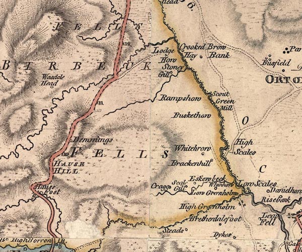 J5NY50NE.jpg "BIRBECK FELLS" area 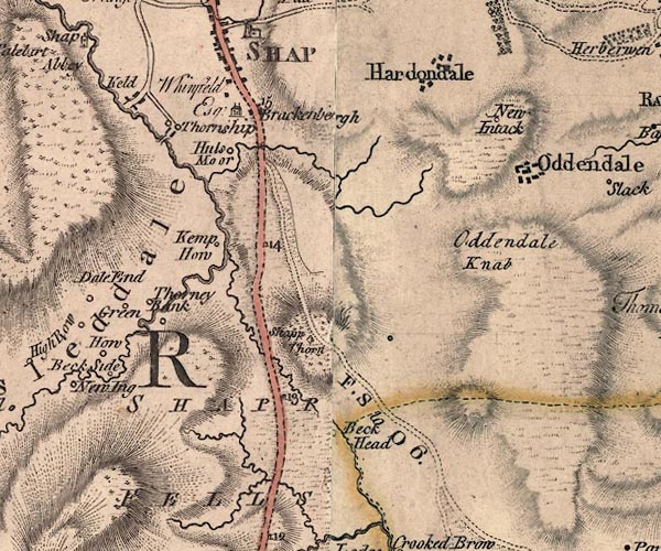 J5NY51SE.jpg "SHAPP FELLS" hill hachuring; hill or mountain item:- National Library of Scotland : EME.s.47 Images © National Library of Scotland |
|
|
|
||
| evidence:- | descriptive text:- West 1778 (11th edn 1821) |
|
| source data:- | Guide book, A Guide to the Lakes, by Thomas West, published by
William Pennington, Kendal, Cumbria once Westmorland, and in
London, 1778 to 1821. goto source goto sourcePage 174:- "[Shap Fells] a dreary, melancholy tract of twelve miles [1]. ..." "[1] This elevated tract being near the centre of Westmorland, and where we may suppose its Genius is most likely to sit enthroned, it may afford the reader a seasonable amusement to peruse in this place a little ode, addressed to that imaginary being, by a late elegant bard, when on one of his visits to his native country." "ODE" "To the Genius of Westmorland." "Hail, hidden Power of these wild groves, / These uncouth rocks and mountains grey; / Where oft, as fades the closing day, / The family of fancy roves." "In what lone cave, what secret cell, / Coeval with the birth of time, / Wrapt in high cares, and thought sublime, / In awful silence dost thou dwell!" "Oft in the depth of winter's reign, / As blew the dark winds o'er the dale, / Moaning along the distant gale, / Has fancy heard thy voice complain." "Oft in the dark wood's lonely way, / Swift has she seen thee glancing by; / Or down the summer evening sky, / Sporting in clouds of gilded day." "I caught from thee the sacred fire, / That glow'd within my youthful breast;- / Those thoughts too high to be express'd, / Genius, if thou didst once inspire." "O! pleas'd, accept this votive lay, / That in my native shade retir'd, / And once, once more by thee inspir'd, / In gratitude I pay." "Langhorne's Effusions of Friendship and Fancy Vol.1, Let.25. X." |
|
|
|
||
| evidence:- | old map:- West 1784 map placename:- Shapfells |
|
| source data:- | Map, hand coloured engraving, A Map of the Lakes in Cumberland,
Westmorland and Lancashire, scale about 3.5 miles to 1 inch,
engraved by Paas, 53 Holborn, London, about 1784.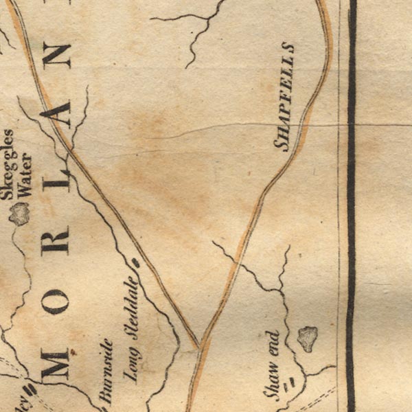 Ws02NY50.jpg "SHAPFELLS" item:- Armitt Library : A1221.1 Image © see bottom of page |
|
|
|
||
| evidence:- | old map:- Cary 1789 (edn 1805) placename:- Shap Fells |
|
| source data:- | Map, uncoloured engraving, Westmoreland, scale about 2.5 miles
to 1 inch, by John Cary, London, 1789; edition 1805.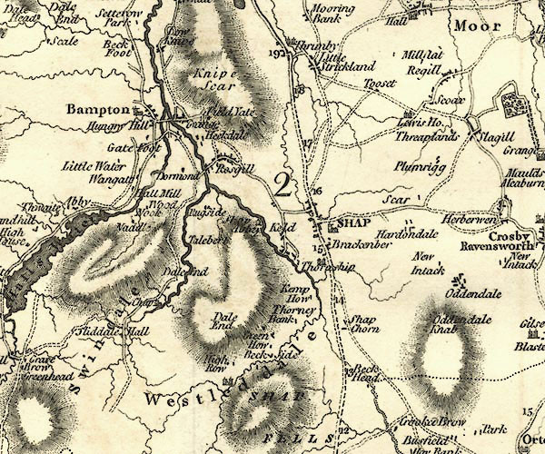 CY24NY51.jpg 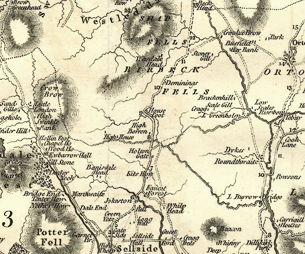 CY24NY50.jpg "SHAP FELLS" hill hachuring item:- JandMN : 129 Image © see bottom of page |
|
|
|
||
| evidence:- | descriptive text:- Otley 1823 (5th edn 1834) item:- geology; glacial erratic |
|
| source data:- | Guide book, A Concise Description of the English Lakes, the
mountains in their vicinity, and the roads by which they may be
visited, with remarks on the mineralogy and geology of the
district, by Jonathan Otley, published by the author, Keswick,
Cumberland now Cumbria, by J Richardson, London, and by Arthur
Foster, Kirkby Lonsdale, Cumbria, 1823; published 1823-49,
latterly as the Descriptive Guide to the English Lakes. goto source Page 151:- "... Another variety of granite with reddish felspar in large crystals, is found on Shap Fells, and may be observed in situ on the road side near Wasdale Bridge, about four miles south of Shap." "..." goto sourcePage 161:- "A superincumbent bed of limestone, by some called the mountain, by others the upper transition limestone, mantles round these mountains, in a position unconformable to the strata of the slaty and other rocks upon which it reposes. It bassets out near ... Dacre, Lowther and Shap; ..." "..." Page 163:- "Bowlder stones are often met with, far removed from their native rock, but do not appear to have been carried over high mountain ridges. The granite blocks from Shap Fells are carried over a great part of Westmorland; but are not found in the" goto sourcePage 164:- "neighbourhood of the lakes. ..." |
|
|
|
||
| evidence:- | old map:- Ford 1839 map placename:- Shap Fells |
|
| source data:- | Map, uncoloured engraving, Map of the Lake District of
Cumberland, Westmoreland and Lancashire, scale about 3.5 miles
to 1 inch, published by Charles Thurnam, Carlisle, and by R
Groombridge, 5 Paternoster Row, London, 3rd edn 1843.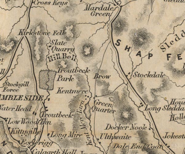 FD02NY40.jpg 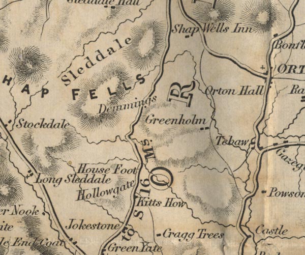 FD02NY50.jpg "SHAP FELLS" Hill hachuring. item:- JandMN : 100.1 Image © see bottom of page |
|
|
|
||
| evidence:- | old map:- Ford 1839 map placename:- Shap Fells |
|
| source data:- | Map, uncoloured engraving, Map of the Lake District of
Cumberland, Westmoreland and Lancashire, scale about 3.5 miles
to 1 inch, published by Charles Thurnam, Carlisle, and by R
Groombridge, 5 Paternoster Row, London, 3rd edn 1843. FD02NY40.jpg FD02NY50.jpg "SHAP FELLS" Hill hachuring. item:- JandMN : 100.1 Image © see bottom of page |
|
|
|
||
| evidence:- | old map:- Garnett 1850s-60s H placename:- Shap Fells |
|
| source data:- | Map of the English Lakes, in Cumberland, Westmorland and
Lancashire, scale about 3.5 miles to 1 inch, published by John
Garnett, Windermere, Westmorland, 1850s-60s. GAR2NY50.jpg "Shap Fells" area item:- JandMN : 82.1 Image © see bottom of page |
|
|
|
||
| evidence:- | old text:- Burrow 1920s placename:- |
|
| source data:- | Road book, strip maps with parts in Westmorland, Cumberland etc,
irregular scales about 1.5 miles to 1 inch, by E J Burrow and
Co, Cheltenham, Gloucestershire, 1920s. "... This is some of the loneliest country in England, a rare place for deep snowdrifts even in winters that are mild elsewhere. The road climbs Shap Fell to a height of 1,400 feet, with a bog at the top and then a descent to Shap village. This district is the place of origin of those great boulders of Shap granite whose presence in widely separated parts of England affords one of the most striking evidences of the glacial epoch of the dim past. Ages before man lived in Britain great glaciers ground their incredible way across the primeval landscape, rolling along with them detached fragments of the rocky mountains whose ultimate shape they helped to fashion. Passengers up the Great North Road may see one of these boulders of Shap granite at Thirsk in North Yorkshire, sixty miles from Shap as the crow flies, and goodness knows how many more miles by the devious ways of glaciers. The name of Shap is famous in English geology. ..." |
|
|
|
||
| evidence:- | old print:- MacBride 1922 placename:- Shap Fells |
|
| source data:- | Print, colour, Shap Abbey and Fells, by Alfred Heaton Cooper, published by Adam and
Charles Black, 4-6 Soho Square, London, 2nd edn 1928.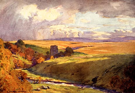 click to enlarge click to enlargeMB0107.jpg Tipped in opposite p.32 in Wild Lakeland by MacKenzie MacBride. printed at bottom:- "SHAP ABBEY AND FELLS" signed at lower left:- "A. HEATON COOPER" item:- JandMN : 195.9 Image © see bottom of page |
|
|
|
||
| hearsay:- |
The first sod of the Lancaster and Carlisle Railway was cut on Shap Fell, 1844. |
|
|
|
||
Lakes Guides menu.