 Old Cumbria Gazetteer
 |
 |
|
| Scandale Head, Lakes | ||
| Scandale Head | ||
| locality:- | Scandale | |
| civil parish:- | Lakes (formerly Westmorland) | |
| county:- | Cumbria | |
| coordinates:- | NY38060983 | |
| 1Km square:- | NY3809 | |
| 10Km square:- | NY30 | |
| SummaryText:- | modern maps show this as the hill top; the OS County series shows it as the dale head. | |
|
|
||
| evidence:- | old map:- OS County Series (Wmd 19 10) placename:- Scandale Head |
|
| source data:- | Maps, County Series maps of Great Britain, scales 6 and 25
inches to 1 mile, published by the Ordnance Survey, Southampton,
Hampshire, from about 1863 to 1948. |
|
|
|
||
| evidence:- | outline view:- Martineau 1855 |
|
| source data:- | Print, engraving, outline view, Mountains seen on the Keswick Road approaching Ullswater,
drawn by L Aspland, engraved by W Banks, Edinburgh, published by John Garnett, Windermere,
Westmorland, and by Whittaker and Co, London, 1855.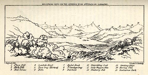 click to enlarge click to enlargeMNU115.jpg Opposite p.104 in A Complete Guide to the English Lakes, by Harriet Martineau. "MOUNTAINS SEEN ON THE KESWICK ROAD APPROACHING ULLSWATER." "L Aspland Delt. / W Banks Sc Edinr." The view is captioned, numbers referring to mountains in the image:- "1 Place Fell, 2 Birk Fell, 3 Red Screes, 4 Scandale Head, 5 Dove Crag (Hartsop), 6 Birks, 7 Rydal Head, 8 St. Sundays Crag, 9, Fairfield, 10 Glenridding Dod, 11 Dolly Waggon Pike, 12 Bleaberry Fell, 13 Striding Edge, 14 Herring Pike, 15 Gowbarrow Park." item:- Armitt Library : A1159.15 Image © see bottom of page |
|
|
|
||
 Lakes Guides menu.