 Old Cumbria Gazetteer
 |
 |
|
| roman fort, Hardknott Pass | ||
| Mediobogdum | ||
| Hardknott Castle | ||
| locality:- | Hardknott Pass | |
| locality:- | road, Ambleside to Ravenglass | |
| civil parish:- | Eskdale (formerly Cumberland) | |
| county:- | Cumbria | |
| locality type:- | roman fort | |
| coordinates:- | NY21850147 | |
| 1Km square:- | NY2101 | |
| 10Km square:- | NY20 | |
| altitude:- | 800 feet | |
| SummaryText:- | Built to control the road between Ambleside and Ravenglass, between 120-138. | |
|
|
||
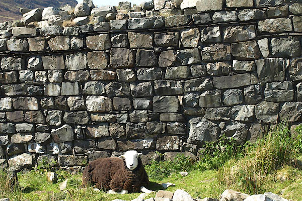
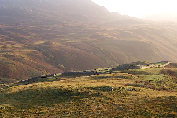 BMW37.jpg (taken 13.10.2006) 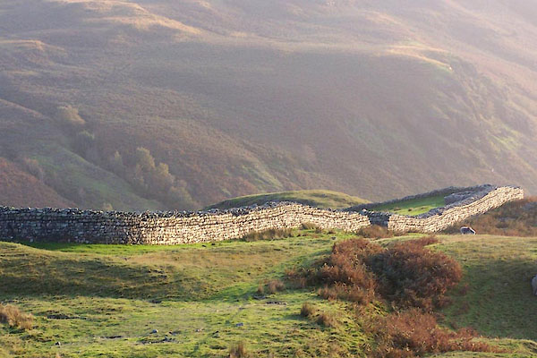 BMW38.jpg North wall. (taken 13.10.2006) |
||
|
|
||
| evidence:- | presumably old text:- Camden 1789 (Gough Additions) placename:- |
|
| source data:- | Book, Britannia, or A Chorographical Description of the Flourishing Kingdoms of England,
Scotland, and Ireland, by William Camden, 1586, translated from the 1607 Latin edition
by Richard Gough, published London, 1789. goto source goto sourcePage 180:- "The foundations on Hardknot may have belonged to some chapel or cross, built there as an eminent place. ..." |
|
|
|
||
| evidence:- | old text:- Camden 1789 |
|
| source data:- | Book, Britannia, or A Chorographical Description of the Flourishing Kingdoms of England,
Scotland, and Ireland, by William Camden, 1586, translated from the 1607 Latin edition
by Richard Gough, published London, 1789. goto source Page 169:- "..." "... Hard knott, a very steep mountain, on whose summit were lately discovered huge stones and foundations of a castle, to the astonishment of the beholders, it being so steep as hardly to be ascended. ..." |
|
|
|
||
| evidence:- | descriptive text:- Otley 1823 (5th edn 1834) |
|
| source data:- | Guide book, A Concise Description of the English Lakes, the
mountains in their vicinity, and the roads by which they may be
visited, with remarks on the mineralogy and geology of the
district, by Jonathan Otley, published by the author, Keswick,
Cumberland now Cumbria, by J Richardson, London, and by Arthur
Foster, Kirkby Lonsdale, Cumbria, 1823; published 1823-49,
latterly as the Descriptive Guide to the English Lakes. goto source Page 83:- "... On the west side of the mountain Hardknot, a space of about two acres is encompassed by the remains of a wall, with places of entrance on each of the four sides. There seem to have been towers at the different gates and corners, and several interior erections." goto sourcePage 108:- "... half way down the hill on the right, are the ruins of a place called Hardknot Castle, described in a former page; but having been built without mortar, or cement, scarcely any part of the walls are left standing." |
|
|
|
||
| evidence:- | old map:- Unknown 1860 |
|
| source data:- | Map, manuscript ink on paper, Sketch of the Pass into West
Cumberland, ie Hardknott Pass, Eskdale, scale about 25 ins to 1
mile, 1860.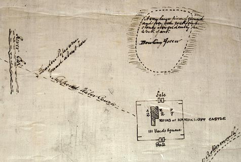 click to enlarge click to enlargeM001P.jpg item:- Carlisle Library : Map 45 Image © Carlisle Library |
|
|
|
||
| evidence:- | old text:- Gents Mag placename:- Hardknott Castle |
|
| source data:- | Magazine, The Gentleman's Magazine or Monthly Intelligencer or
Historical Chronicle, published by Edward Cave under the
pseudonym Sylvanus Urban, and by other publishers, London,
monthly from 1731 to 1922. goto source Gentleman's Magazine 1907 part 1 p.172 "..." "It is probable the "Hardknott Castle" was not a popular post with the officers whose duty it was to take charge of the desolate fort perched high on the shoulder of Hardknott, a craggy mountain looking over the upper valley of the Esk to Sca Fell." "The camp can be traced easily to-day, and it is very interesting. It is some 500 feet above the river, and was evidently built to guard the road which winds on its right over the pass away to Keswick, Ambleside, and thence to York. Some ten miles to the westward this" |
|
|
|
||
| evidence:- | old text:- Gents Mag 1907 |
|
| source data:- | goto source Gentleman's Magazine 1907 part 1 p.174 "road ends at Ravenglass, a tiny village now, but in those far-off days an important military port where very likely troops were landed for the great headquarters of the Roman army at York. It is conjectured that this camp is identicial with Maia, a station whose situation is judged to probably to be in south-west Cumberland. Of the actual history of the camp little is known. It is mentioned by Camden, who suggests that though it may be a castle, it is possibly the remains of some church or chapel. It is also mentioned in "Hutchinson's History of Cumberland," and other works, but it was not systematically explored till 1889, when Mr. H. Swainson-Cowper, F.S.A., began the work of excavation by clearing the north tower. Sir Herbert Maxwell, in 1890 and 1891, continued the work thus begun, and a regular system of continuous operations was adopted in 1892 by the late Rev. W. S. Calverly, F.S.A., with Mr. Dymond, F.S.A., as engineer and surveyor." "They found much of great interest, tracing out the shape of the fort and determining its materials, and the relics enshrouded by its debris." "The fort itself is almosts square in shape with four gates and a tower at each angle, N., S., E. and W., each being about twelve feet square. The north tower is the highest of these, and commands a magnificent view up the valley of the Upper Esk away to Sca Fell, and also down to the sea, in which on clear days the Isle of Man is visible." "The walls were originally built of the granite stone of the neighbourhood, but the angles were made of dressed red sandstone, which must have been brought from at least ten or eleven miles away. Mortar was used; it can be seen in the walls if carefully looked for. The walls were about five feet in thickness." "The porta principalis sinistra (the gate on the north-east side) has a road which leads to the Parade Ground, some six hundred feet beyond the fort. The Parade Ground is nearly three acres in extent; the boulders have been cleared away, and it has been roughly levelled for the" |
|
|
|
||
| evidence:- | old text:- Gents Mag 1907 |
|
| source data:- | goto source Gentleman's Magazine 1907 part 1 p.175 "troops to exercise. On its north side is a great mound (of artifical construction) probably a kind of grand stand from which the officers could watch the manoeuvres of their men." "At the south side of the camp, about two hundred feet below the east tower on the side of the road leading to the south-east gateway (the porta praetoria), are two buildings which were cleared under the immediate direction of Mr. Calverley. One of these buildings contains three large rooms and one small one. It is provided with the usual hypocausts for heating. The small compartment is supposed to be either a cistern or a bath; it is in the room at the north end of the building. At the southern end of the house is a large praefurnium for heating the hypocausts. Adjacent, but quite separate, is a circular building some fifteen feet in diameter, which has evidently been plastered with a red-coloured plaster. Its use has not definitely been ascertained, though the late Chancellor Ferguson suggested that it might be a shrine to the goddess Feronia, while the building nearby was a wayside tavern.1" "Inside the walls are three groups of buildings, the praetorium being in the middle; east of the praetorium is a smaller building that might have been officers' quarters, and west of it is another structure that some believe to have been stables, while other authorities incline to think that it formed soldiers' quarters." "Water for the camp was probably obtained from a stream issuing from the fell behind. In an account of the camp in Hutchinson's History given by Abraham Marshall, for many years incumbent of Eskdale (he rests now in the churchyard beside the river Esk), we read that pieces of a leather water-pipe were found leading to the fort from a well called Maddock How. I have not heard, however, that the excavations yielded any further traces of water-pipes or conduits." "During the excavations many relics were found both of" "1 See "Transactions of the Cumberland and Westmorland Antiquarian Society," vol.xii. p.389." |
|
|
|
||
| evidence:- | old text:- Gents Mag 1907 item:- roman finds |
|
| source data:- | goto source Gentleman's Magazine 1907 part 1 p.176 "bronze and iron; also various kinds of pottery, though there was very little of really fine Samian ware." "Many fragments of glass and lead showed that the windows of the fort were glazed. Several pieces of jewellery were found, one being a fish with an enamelled red eye. In the three-roomed house outside the fort remains of a cat and kittens (or dog and puppies) were found under the debris of the roof and walls. Slates were discovered amongst the ruins showing that the dwellings had all been roofed with slates." "..." |
|
|
|
||
| evidence:- | old text:- Gents Mag item:- roman finds |
|
| source data:- | Magazine, The Gentleman's Magazine or Monthly Intelligencer or
Historical Chronicle, published by Edward Cave under the
pseudonym Sylvanus Urban, and by other publishers, London,
monthly from 1731 to 1922. goto source Gentleman's Magazine 1907 part 1 p.176 conitunued "..." "How the camp was overthrown after the departure of its Roman occupants we do not know, but its ruin was evidently completed by fire. Perhaps the barbarian hordes lurking among the grim fastnesses of the mountains around descended upon it. History, at any rate, is silent upon this point." "Many of the sandstone door-posts, corner-stones, etc., were carried away in later times. Some of them were found by Mr. Calverley in use as cheese-presses, etc., at farms in the neighbourhood. Still sufficient of the camp is left for us to build up in the imagination what it once was. We can see what an imposing edifice it must have appeared to the wild hillmen, perched in mid-air on the edge of a crag round which mists swirled and snow drove. It must have been a dreary spot in winter for those Roman soldiers, with the north wind from Sca Fell and Bow Fell howling round it, and wild boars and wolves prowling, perhaps, outside its gates." "A wild boar's tusk was found amongst its debris, and portions of the antlers of red deer. To-day hares and foxes may be found amongst its ruins, while ravens still have a nesting-place in the crags above, and buzzard hawks and peregrine falcons hover above it in its bleak desolation." "The view from the camp on a fine day is so beautiful as to make it well worth a visit independently of the great interest of its relics from an antiquarian point of view. It is doubly interesting, perhaps, by reason of the mystery which enshrouds it. Of its builders we know" |
|
|
|
||
| evidence:- | old text:- Gents Mag 1907 |
|
| source data:- | goto source Gentleman's Magazine 1907 part 1 p.177 "definitely nothing save that they were Romans: of its subsequent history we know nothing. It was just a hill station, a fort - probably one of a chain - guarding an important highway. With that we must rest content; but in imagination, sitting up there, we may picture many" 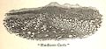 click to enlarge click to enlargeG907E04.jpg "things, trying to piece together its history. At present it is undisturbed. Doubtless in future times a railway will run to Keswick and Ambleside by way of Hardknott, and the ghosts of the Roman sentries will marvel as they pace outside the overthrown gates. But in our day it is a place of peace, a spot to wonder over and to think upon, a piece of Forgotten History." |
|
|
|
||
| evidence:- | text:- Rivet and Smith 1979 placename:- Mediobogdum placename:- Medibogdo placename:- Medebogdo |
|
| source data:- | ||
|
|
||
 BYL53.jpg Stone wall, original up to the line of slates which mark from where restoration has been done. (taken 4.6.2013) 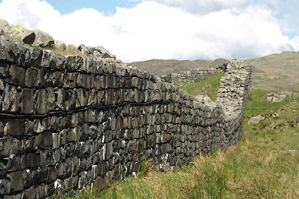 BYL54.jpg Stone wall, original up to the line of slates which mark from where restoration has been done. (taken 4.6.2013) 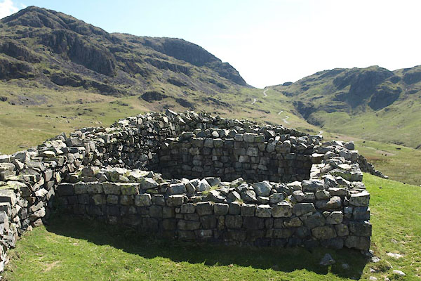 BYL55.jpg Turret, north corner. (taken 4.6.2013) 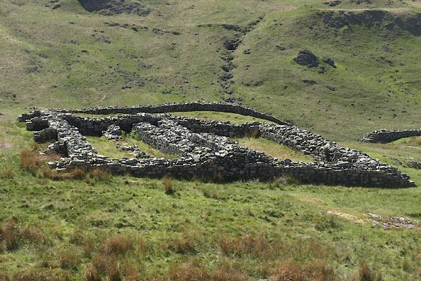 BYL56.jpg Horrea; granaries. (taken 4.6.2013) 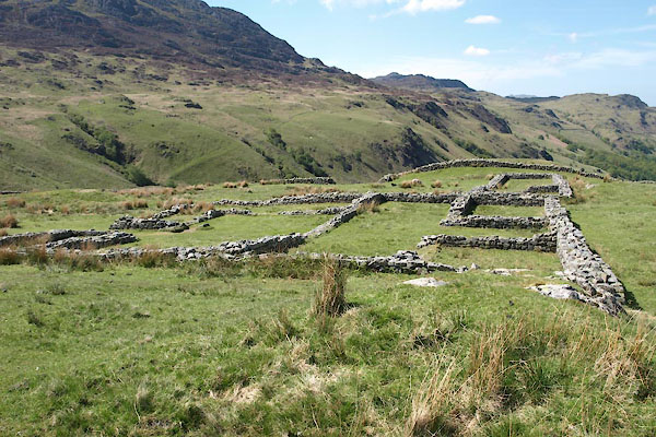 BYL57.jpg Principia; administrative buildings. (taken 4.6.2013) 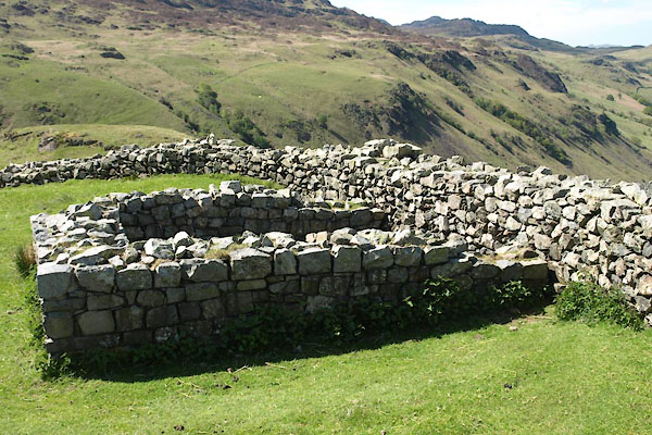 BYL58.jpg Turret, west corner. (taken 4.6.2013) 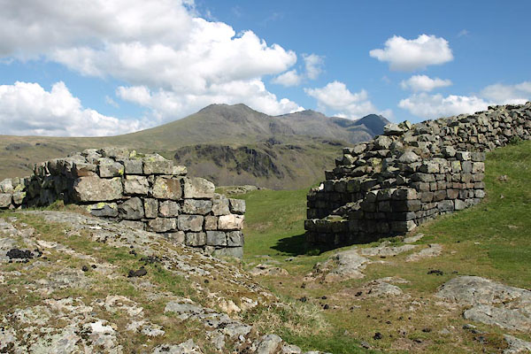 BYL59.jpg North west gate. (taken 4.6.2013) 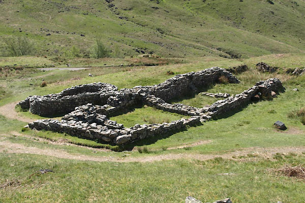 BYL60.jpg Bath house. (taken 4.6.2013) 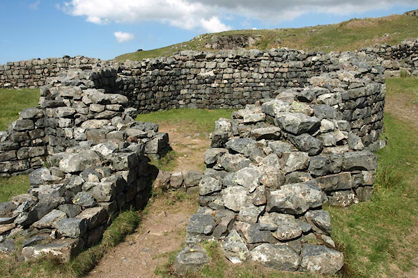 BYL61.jpg Bath house, laconium. (taken 4.6.2013) 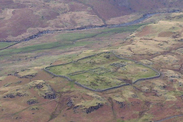 BNJ75.jpg From the south. (taken 14.3.2007) 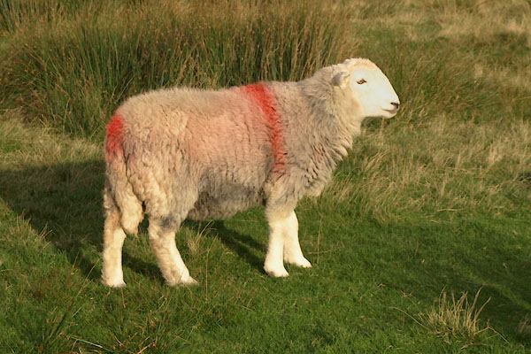 BVM42.jpg Herdwick sheep, Brotherilkeld Farm? Red stroke over and down both shoulders, red pop on tail head. (taken 7.10.2011) |
||
|
|
||
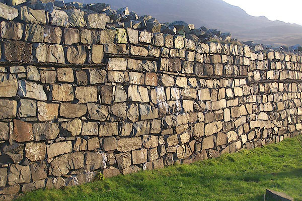 BMW39.jpg Stone wall. (taken 13.10.2006) 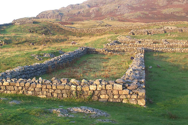 BMW41.jpg Administrative buildings. (taken 13.10.2006) 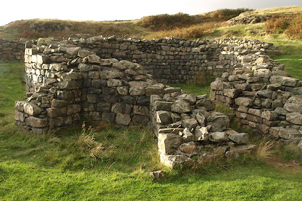 BVM41.jpg Bath house. (taken 7.10.2011) |
||
|
|
||
| : 1928: Trans CWAAS: series 2 vol.28: pp.314-352 : 1965: Trans CWAAS: series 2 vol.65: pp.169-175 |
||
|
|
||
| notes:- |
Roman fort, 2 3/4 acres, at 800 feet OD. Established about AD 103. A bath house and
a parade ground lie outside the fort. |
|
|
|
||
| person:- | : English Heritage |
|
|
|
||
Lakes Guides menu.