 Old Cumbria Gazetteer
 |
 |
|
| Rockcliffe Castle, Rockcliffe | ||
| gone | ||
| Rockcliffe Castle | ||
| locality:- | Rockcliffe | |
| civil parish:- | Rockcliffe (formerly Cumberland) | |
| county:- | Cumbria | |
| locality type:- | castle (site) | |
| coordinates:- | NY35356194 (?) | |
| 1Km square:- | NY3561 | |
| 10Km square:- | NY36 | |
|
|
||
| evidence:- | old map:- OS County Series (Cmd 16 5) |
|
| source data:- | Maps, County Series maps of Great Britain, scales 6 and 25
inches to 1 mile, published by the Ordnance Survey, Southampton,
Hampshire, from about 1863 to 1948. "Castle (Site of)" |
|
|
|
||
| evidence:- | old map:- Saxton 1579 placename:- Rowcliff Castle |
|
| source data:- | Map, hand coloured engraving, Westmorlandiae et Cumberlandiae Comitatus ie Westmorland
and Cumberland, scale about 5 miles to 1 inch, by Christopher Saxton, London, engraved
by Augustinus Ryther, 1576, published 1579-1645.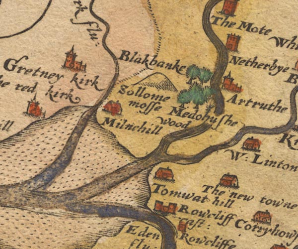 Sax9NY36.jpg Building with two towers, symbol for a castle. "Rowcliff cast:" item:- private collection : 2 Image © see bottom of page |
|
|
|
||
| evidence:- | old map:- Burghley 1590 (facsimile) placename:- Rokelif Castel |
|
| source data:- | Facsimile map, A Platt of the Opposete Border of Scotland to ye West Marches of England,
parts of Cumberland and Scotland including the Debateable Land, from a manuscript
drawn for William Cecil, Lord Burghley, about 1590, published by R B Armstrong, 1897. courtesy of the National Library of Scotland 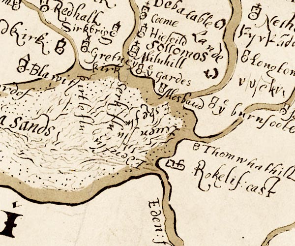 M048NY36.jpg "Rokelif. cast" perhaps circle, tower item:- National Library of Scotland : MS6113 f.267 Image © National Library of Scotland |
|
|
|
||
| evidence:- | old map:- Speed 1611 (Cmd) placename:- Rowcliff Castle |
|
| source data:- | Map, hand coloured engraving, Cumberland and the Ancient Citie
Carlile Described, scale about 4 miles to 1 inch, by John Speed,
1610, published by J Sudbury and George Humble, Popes Head
Alley, London, 1611-12.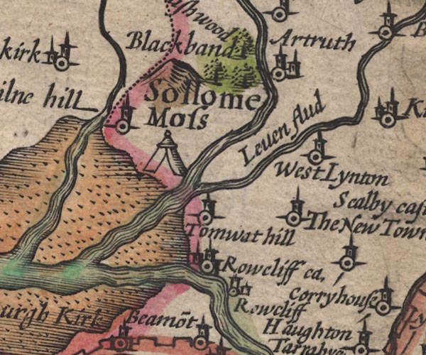 SP11NY36.jpg "Rowcliff ca." circle, towers item:- private collection : 16 Image © see bottom of page |
|
|
|
||
| evidence:- | probably old map:- Jansson 1646 placename:- Rowcliff Castle |
|
| source data:- | Map, hand coloured engraving, Cumbria and Westmoria, ie
Cumberland and Westmorland, scale about 3.5 miles to 1 inch, by
John Jansson, Amsterdam, Netherlands, 1646.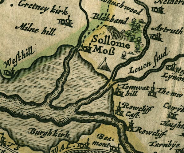 JAN3NY36.jpg "Rowcliff Cast." Buildings and tower with flag. item:- JandMN : 88 Image © see bottom of page |
|
|
|
||
| evidence:- | old map:- Sanson 1679 placename:- Rookley Castle |
|
| source data:- | Map, hand coloured engraving, Ancien Royaume de Northumberland
aujourdhuy Provinces de Nort, ie the Ancient Kingdom of
Northumberland or the Northern Provinces, scale about 9.5 miles
to 1 inch, by Nicholas Sanson, Paris, France, 1679. click to enlarge click to enlargeSAN2Cm.jpg "Rookley C." circle, perhaps towers, flag; castle item:- Dove Cottage : 2007.38.15 Image © see bottom of page |
|
|
|
||
| evidence:- | old map:- Morden 1695 (Cmd) placename:- Rowcliff Castle |
|
| source data:- | Map, uncoloured engraving, Cumberland, scale about 4 miles to 1
inch, by Robert Morden, 1695, published by Abel Swale, the
Unicorn, St Paul's Churchyard, Awnsham, and John Churchill, the
Black Swan, Paternoster Row, London, 1695-1715.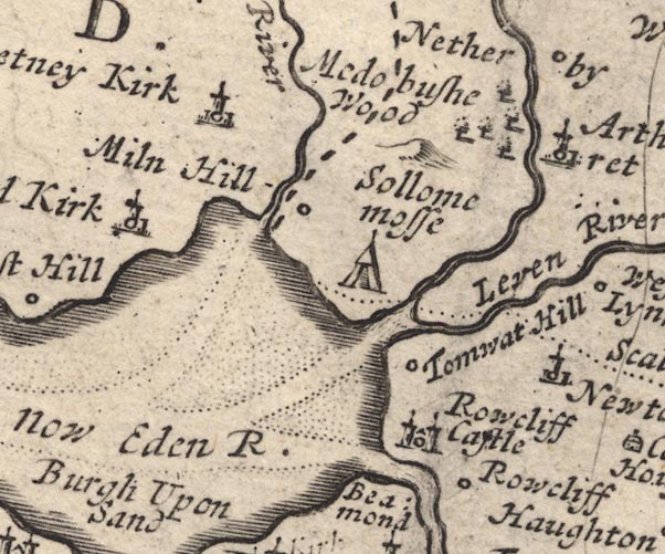 MD12NY36.jpg "Rowcliff Castle" Circle, building with two towers. item:- JandMN : 90 Image © see bottom of page |
|
|
|
||
| evidence:- | old map:- Badeslade 1742 placename:- Rowclif Castle |
|
| source data:- | Map, uncoloured engraving, A Map of Cumberland North from
London, scale about 11 miles to 1 inch, with descriptive text,
by Thomas Badeslade, London, engraved and published by William
Henry Toms, Union Court, Holborn, London, 1742. click to enlarge click to enlargeBD10.jpg "Row[clif] C" circle, italic lowercase text; castle item:- JandMN : 115 Image © see bottom of page |
|
|
|
||
| evidence:- | old text:- Clarke 1787 placename:- Rowcliff Castle |
|
| source data:- | Guide book, A Survey of the Lakes of Cumberland, Westmorland,
and Lancashire, written and published by James Clarke, Penrith,
Cumberland, and in London etc, 1787; published 1787-93. goto source goto sourcePage 105:- "..." "I do not find any ancient authors mention a castle here [Castlerigg], Speed, who speaks of twenty-five in Cumberland, hath found out every one I ever heard or knew of, except Kirkoswald; how that has escaped him I cannot tell. I shall here put down their names, and, as well as I can, their most ancient owners, and supposed founders." "..." goto sourcePage 106:- "..." "9. ROWCLIFF. Adam de Bray." "..." |
|
|
|
||
| evidence:- | old text:- Camden 1789 placename:- Rowcliff Castle |
|
| source data:- | Book, Britannia, or A Chorographical Description of the Flourishing Kingdoms of England,
Scotland, and Ireland, by William Camden, 1586, translated from the 1607 Latin edition
by Richard Gough, published London, 1789. goto source Page 175:- "..." "Crossing the Eden now one sees Rowcliff near the bank, a little castle, built by the lords Dacres not long since for the defence of their property. ..." |
|
|
|
||
| evidence:- | old text:- Camden 1789 (Gough Additions) placename:- Rockclif Castle |
|
| source data:- | Book, Britannia, or A Chorographical Description of the Flourishing Kingdoms of England,
Scotland, and Ireland, by William Camden, 1586, translated from the 1607 Latin edition
by Richard Gough, published London, 1789. goto source Page 195:- "..." ""Rockclif, a pretty pile or castle of the lord Daker's over Edon on the farther ripe, about three miles from Caerluell," It was sold by the duke of Norfolk 1682, and now belongs to Mr. Strong of Peterborough." |
|
|
|
||
| evidence:- | text:- Jackson 1990 placename:- Rocliffe castle placename:- Rokele castle |
|
| source data:- | ||
|
|
||
| notes:- |
The castle was built early 16th century, and could garrison 200 men. By 1683 it was
a ruin, and now there is no trace. |
|
|
|
||
| notes:- |
tower and courtyard, demolished; a mansion built on the site |
|
| Perriam, D R &Robinson, J: 1998: Medieval Fortified Buildings of Cumbria: CWAAS::
ISBN 1 873124 23 6 |
||
|
|
||
Lakes Guides menu.