 Old Cumbria Gazetteer
 |
 |
|
||||||||||||||||||
| road, Bassenthwaite Lake | ||||||||||||||||||||
| Bassenthwaite Lake circuit | ||||||||||||||||||||
| civil parish:- | Underskiddaw (formerly Cumberland) | |||||||||||||||||||
| civil parish:- | Bassenthwaite (formerly Cumberland) | |||||||||||||||||||
| civil parish:- | Setmurthy (formerly Cumberland) | |||||||||||||||||||
| civil parish:- | Wythop (formerly Cumberland) | |||||||||||||||||||
| civil parish:- | Above Derwent (formerly Cumberland) | |||||||||||||||||||
| county:- | Cumbria | |||||||||||||||||||
| locality type:- | road route | |||||||||||||||||||
| 10Km square:- | NY22 | |||||||||||||||||||
| 10Km square:- | NY23 | |||||||||||||||||||
|
|
||||||||||||||||||||
| evidence:- | descriptive text:- West 1778 (11th edn 1821) |
|||||||||||||||||||
| source data:- | Guide book, A Guide to the Lakes, by Thomas West, published by
William Pennington, Kendal, Cumbria once Westmorland, and in
London, 1778 to 1821. goto source goto sourcePage 118:- "..." "BASSENTHWAITE-WATER." "Having seen the glory of Keswick, the beauties of the lake, and the wonders of the environs, there remains a pleasant ride to Ouse-bridge, in order to visit the lake of Bassenthwaite. Messrs. Gray and Pennant took the ride, but did not see the beauties of the lake, either for want of time or proper information." goto sourcePage 119:- "Mr. Pennant says, 'Pass along the vale of Keswick, and keep above Bassenthwaite-water, at a small cultivated distance from it: this lake is a fine expanse of 4 miles in length, bounded on one side by high hills, wooded in many places to their bottoms; on the other side, by fields, and the skirts of Skiddaw." "'From Mr. Spedding's, of Armathwaite, at the low extremity of the lake, you have a fine view of the whole.'" "Mr. Gray allowed himself more time for particulars. 'October 6,' he says, 'went in a chaise, eight miles, along the east side of Bassenthwaite water, to Ouse-bridge; it runs directly along the foot of Skiddaw. Opposite to Wythop-brows, clothed to the top with wood, a very beautiful view opens down to the lake, which is narrower and longer than that of Keswick, less broken into bays, and without islands; at the foot of it, a few paces from the brink, gently sloping upwards, stands Armathwaite, in a thick grove of Scotch firs, commanding a noble view directly up the lake. At a small distance behind this, a ridge of cultivated hills, on which, according to the Keswick proverb, the sun always shines; the inhabitants here, on the contrary, call the vale of Derwent-water, the devil's chamberpot, and pronounce the name of" goto sourcePage 120:- "Skiddaw-fell, which terminates here, with a sort of terror and aversion. Armathwaite-house is a modern fabric, not large, and built of dark red stone.'" "..." goto sourcePage 123:- "... from Scareness, take the road to Bassenthwaite-halls (a few houses so called) and from the road on the north side of the village, called Rakes, you have a very fine view of a rich cultivated tract, stretching along the banks of the lake, and spreading itself upwards to the skirts of Skiddaw. The elevation is such, that every object is seen completely, and every beauty distinctly marked. The lakes appears in its full magnitude, shaded by a bold wooded shore on the west, and graced by a sweet spreading vale on the east, that terminates in a bold style under the surrounding mountains. The sloping ground to the bridge is charming, and the far-extended vales of Embleton and Isel lie in fine perspective. The river Derwent has his winding course through the latter." "..." goto sourcePage 126:- "..." "From Caer-mot descend to Ouse-bridge, and return to Keswick up the western side of the lake. Every lover of landscape should take this ride in the afternoon; and if the sun shine it is exceedingly pleasant. The road branches off from the great road to Cockermouth, a little below the bridge, and leads through the wood, and round Castle-how. In some places it rises above the lake a considerable height, and the water is agreeably seen at intervals through a screen of low wood that decks its banks. Then the road descends to the level of the water, and presents you with a variety of surprising views, in different styles, that show themselves in an agreeable succession, as the eye wanders in amazement along the lake." goto sourceAddendum; Mr Gray's Journal, 1769 Page 208:- "..." "Oct. 6. Went in a chaise eight miles along the east side of Bassenthwaite-water to Ouse-bridge, the road in some part made, and very good, the rest slippery and dangerous cart road, or narrow rugged lanes, but no precipices; it runs directly along the foot of Skiddaw. Opposite to Wythop brows, clothed up to the top with wood, a very beautiful view opens down the lake, ..." |
|||||||||||||||||||
|
|
||||||||||||||||||||
| evidence:- | old map:- Crosthwaite 1783-94 (Bas) |
|||||||||||||||||||
| source data:- | Map, uncoloured engraving, An Accurate Map of Broadwater or
Bassenthwaite Lake, scale about 3 inches to 1 mile, by Peter
Crosthwaite, Keswick, Cumberland, 1783, version published 1800. In the map title:- "... NB. When Company wish to visit all West's Stations, and go from KESWICK down the East Side of this Lake; it will most convenient First to proceed to Bradness; second Scarness, Third Sir F. F. Vane's Bart, Fourth the Inn, and from thence along the Western Shore to the last." 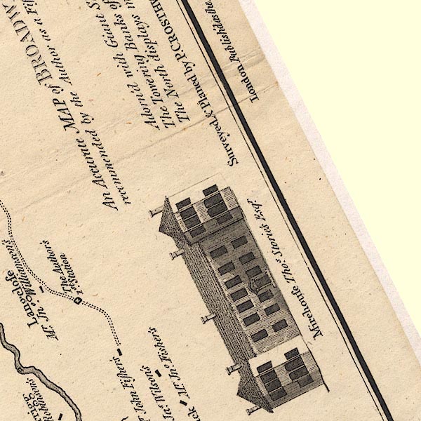 CT6NY22N.jpg 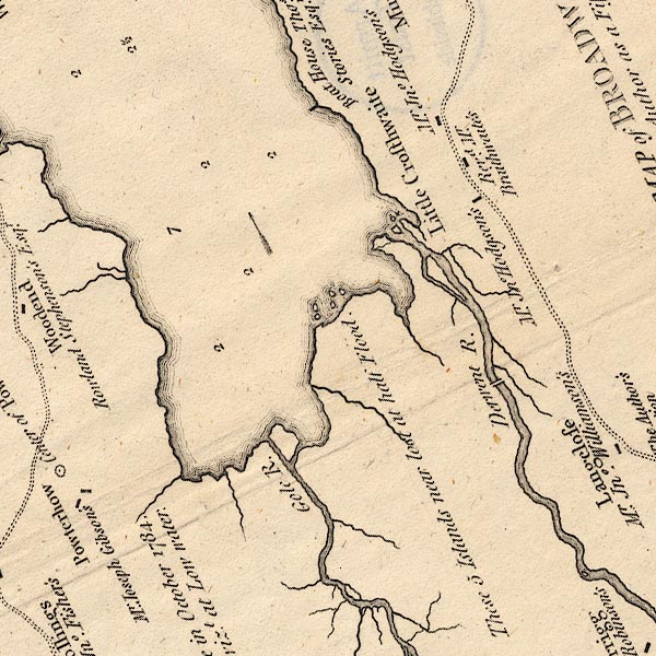 CT6NY22I.jpg 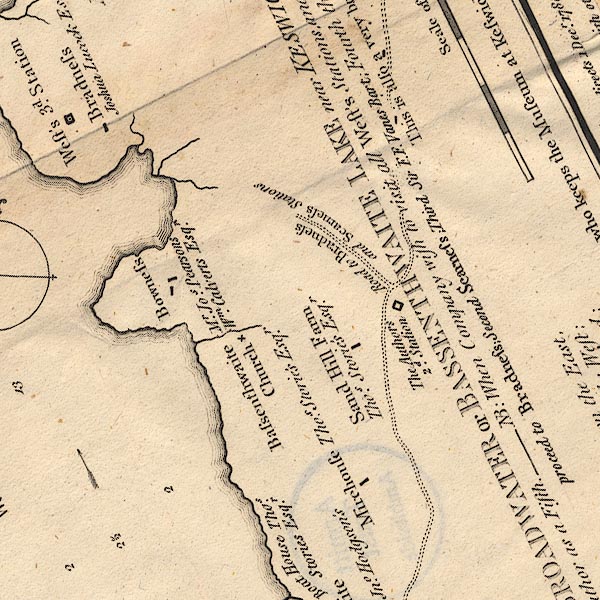 CT6NY22J.jpg 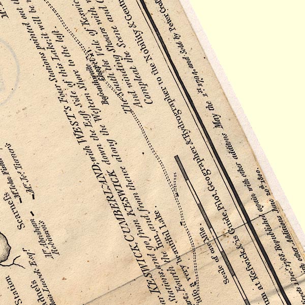 CT6NY23F.jpg 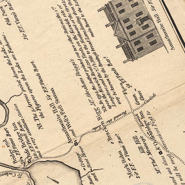 CT6NY23B.jpg "Round the Lake" "Keswick" 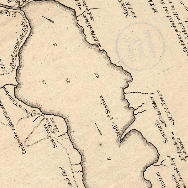 CT6NY23A.jpg "Road round the Lake." 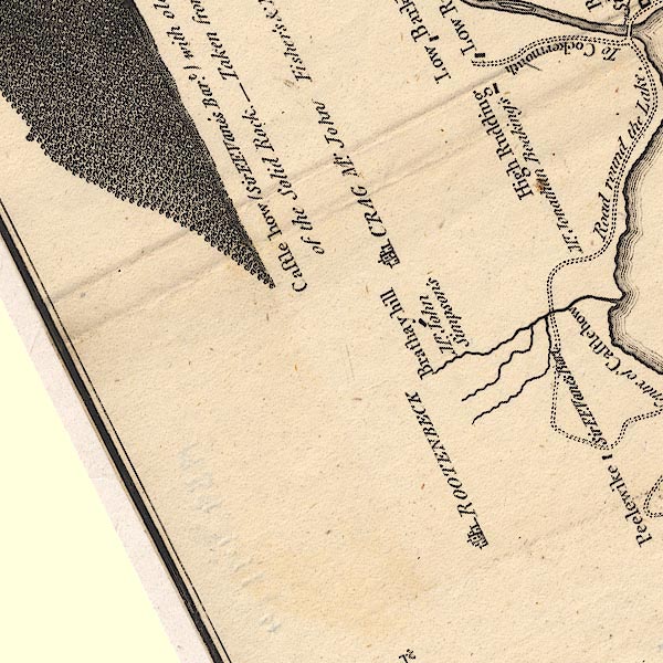 CT6NY13V.jpg 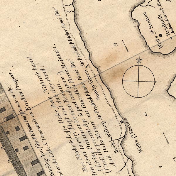 CT6NY22E.jpg 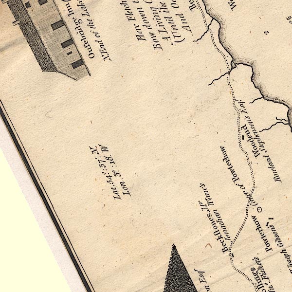 CT6NY22D.jpg item:- Armitt Library : 1959.191.4 Image © see bottom of page |
|||||||||||||||||||
|
|
||||||||||||||||||||
| evidence:- | old text:- Clarke 1787 |
|||||||||||||||||||
| source data:- | Guide book, A Survey of the Lakes of Cumberland, Westmorland,
and Lancashire, written and published by James Clarke, Penrith,
Cumberland, and in London etc, 1787; published 1787-93. goto source Page 93:- "..." "We now travel along Wythop-brow, on a good road, though not very much frequented, but made (as all the roads near the lakes are) for the conveniency of travellers; this road leads along a steep bank, covered from top to bottom with healthy, thriving oaks, which form a grateful and refreshing shade. Passing Beck Wythop and Smiddy Green, which form two beautiful little openings (as if from night to day) we come to Sawyers Cragg; here the road takes a curious turn, as may be seen from the plan, No VIII. Along this road is the best view of Bassenthwaite-Water and Vale, and the best station for this is a little before you come to Sawyers Cragg." "..." "From Sawyer-Cragg we descend a steep hill towards Peelwike; this serpentine road is better seen in the map, (plate VIII.) than I can describe it, and the reason of its remarkable turns is owing to a very steep rock, and a peat-mire at the high end of it, both of which are impassable." "..." goto sourcePage 97:- "..." "We now leave Armathwaite, and proceeding towards Keswick, meet with a very perplexed road; to this, however, the plan will be a sufficient guide. The road leads through rich inclosures, with serpentine hedges; these, though both beautiful and fashionable, are by no means profitable, for they are a very great obstruction to the plough." "..." "... The road we now travel is very agreeable and well-finished, about 200 yards excepted, which leads from Sawyer-Cragg to Peel-Wike. Since the division of the common, every thing shews the marks of improvement, joined with natural beauty, and some remains of its primeval wildness." "..." goto sourcePage 100:- "..." "From hence [Ormathwaite] are two roads to Keswick, as will appear by the plan: the road by Monks-Hall does not, however, afford any thing entertaining, and is, besides, viewed in our road to Skiddow. ..." "The other road which leads past the vicarage affords the grandest view for the artist of any in this country. Mr Gray describes it, but did not leave his road for it; and only viewed from the horsing-stone at the parsonage house ..." |
|||||||||||||||||||
|
|
||||||||||||||||||||
| evidence:- | old map:- Clarke 1787 map (Bassenthwaite Lake) |
|||||||||||||||||||
| source data:- | Map, A Map of Broadwater and its Environs, ie Bassenthwaite
Lake, scale about 6.5 ins to 1 mile, by James Clarke, engraved
by Neele, 352 Strand, published by James Clarke, Penrith,
Cumberland and in London etc, 1787.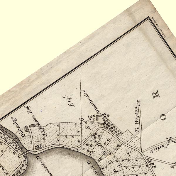 CL8NY23B.jpg 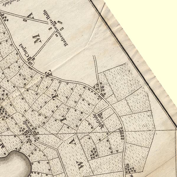 CL8NY23F.jpg 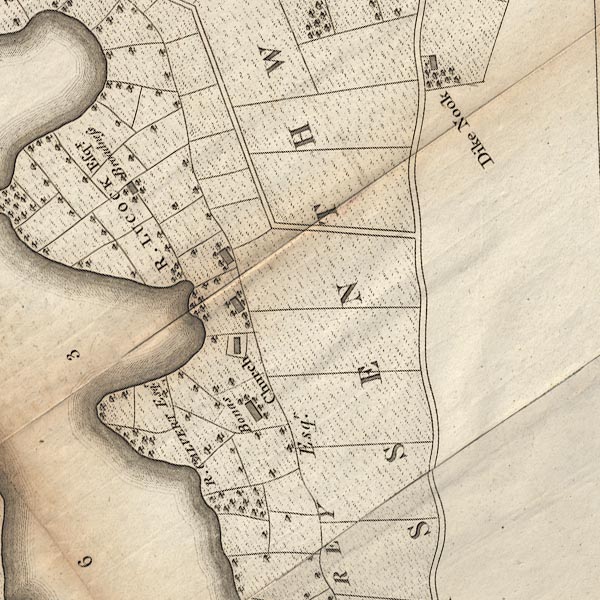 CL8NY22J.jpg 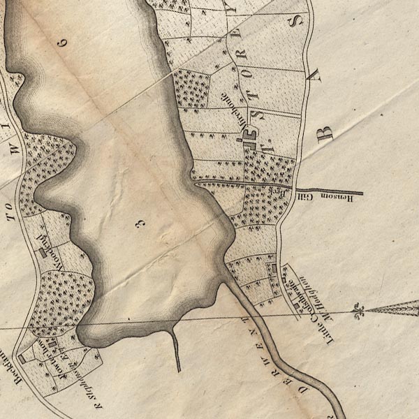 CL8NY22I.jpg 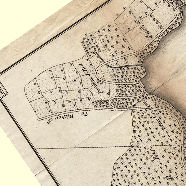 CL8NY13V.jpg  CL8NY23A.jpg  CL8NY22E.jpg 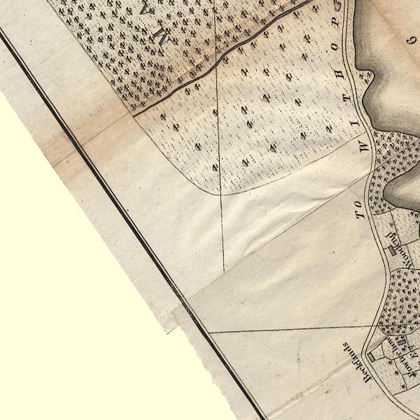 CL8NY22D.jpg "To WITHOP" And a hand pointing the way. item:- private collection : 10.8 Image © see bottom of page |
|||||||||||||||||||
|
|
||||||||||||||||||||
| evidence:- | old text:- Green 1810 |
|||||||||||||||||||
| source data:- | Set of prints, soft ground etchings, Sixty Studies from Nature,
by William Green, Ambleside, Westmorland, drawn 1808-10,
published 1810. goto source page 72:- "..." "There is a carriage road from Keswick round Bassenthwaite Water, and it is not of much importance which side of the lake is first travelled; the Bassenthwaite side of the road is between Skiddaw and the lake, and cannot be mistaken; and either looking forward or backward the scenes are good, though not so great as those in some other parts of the country. ..." "..." page 73:- "... From Ouse Bridge, the road is by Peterhow, a rock covered with woods, to the margin of the lake on the western side; and Skiddaw is a fine object for a few miles, ..." |
|||||||||||||||||||
|
|
||||||||||||||||||||
| evidence:- | descriptive text:- Otley 1823 (5th edn 1834) item:- itinerary; road distances |
|||||||||||||||||||
| source data:- | Guide book, A Concise Description of the English Lakes, the
mountains in their vicinity, and the roads by which they may be
visited, with remarks on the mineralogy and geology of the
district, by Jonathan Otley, published by the author, Keswick,
Cumberland now Cumbria, by J Richardson, London, and by Arthur
Foster, Kirkby Lonsdale, Cumbria, 1823; published 1823-49,
latterly as the Descriptive Guide to the English Lakes. goto source Page 22:- "... tourists who have leisure for a ride or a drive of eighteen miles, round this lake [Bassentwhaite Lake], may obtain some pleasing views; especially from the foot of the lake, and from some points of Wythop woods. ..." "..." goto sourcePage 135:- "DRIVE ROUND BASSENTHWAITE LAKE." "... tourists who prefer an easy journey, will find objects to please, in a perambulation of 18 miles round this lake. On the western side the road is much improved, and rendered very commodious for travelling; it is some parts enclosed in woods, in others opening to excellent views. There is a public-house at Peel Wyke on the western side, another at Castle Inn on the eastern. The road at the foot of the lake is much encumbered by trees; but by walking a few paces through a gate, nearly opposite Armathwaite Hall, the prospect from the margin of the lake is extensive; and the botanist may perhaps find something worth his notice. On the eastern side, the traveller would sometimes wish for a nearer approach to the lake; but few would think themselves repaid for the trouble of visiting West's stations on the promontories of Broadness and Scarness." goto sourcePage 136:- "Those who are not inclined to make the whole circuit of the lake, may take a ride by the foot of Skiddaw, to a station a little above the road upon an open common, at the distance of five miles from Keswick. Here the principal part of the lake may be seen, with the three bold promontories of Bowness, Broadness, and Scarness, and in returning (if on horseback or on foot) take the upper road, by Milbeck, Applethwaite, and Ormathwaite, from whence some of the best views of Derwent Lake and its environs will be found. From Applethwaite or Ormathwaite, they may either take the nearest road to Keswick, or proceed by Mr. Calvert's occupation way along the side of Latrigg, and enter the town by the Penrith road."
|
|||||||||||||||||||
|
|
||||||||||||||||||||
| evidence:- | old text:- Martineau 1855 |
|||||||||||||||||||
| source data:- | Guide book, A Complete Guide to the English Lakes, by Harriet
Martineau, published by John Garnett, Windermere, Westmorland,
and by Whittaker and Co, London, 1855; published 1855-76. goto source Page 88:- "... the drive of eighteen miles round it is, in truth, a very pleasant one." goto sourcePage 89:- "... The side opposite Skiddaw is the most interesting of the two; so the traveller takes it first. The road passes through Portinscale and Braithwaite to Thornthwaite, and leaves Whinlatter on the left. It passes through woods and pretty glades which make a charming foreground, while old Skiddaw fills the view on the opposite shore. Lord's Seat and Barf rise boldly to the left, and the road runs, for the most part, on the margin of the lake. It winds round, after passing Peel Wyke, to Ouse Bridge, beneath which the lake discharges itself in the form of the much enlarged river Derwent, which flows away towards Cockermouth. ... From Castle Inn, it is eight miles to Keswick. The road turns away from the lake, and presents nothing more of remarkable beauty." |
|||||||||||||||||||
|
|
||||||||||||||||||||
| evidence:- | old strip map:- Rumney 1899 |
|||||||||||||||||||
| source data:- | Road map, strip map and itinerary for Route XI, Round Bassenthwaite Lake, Cumberland,
scale about 2 miles to 1 inch, by A W Rumney, published by George Philip and Son,
32 Fleet Street, London, and Liverpool, 1899.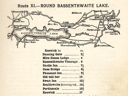 click to enlarge click to enlargeRUM113.jpg On p.41 of the Cyclist's Guide to the English Lake District, by A W Rumney. printed at top:- "Route XI. - ROUND BASSENTHWAITE LAKE." item:- JandMN : 147.14 Image © see bottom of page |
|||||||||||||||||||
|
|
||||||||||||||||||||
| also see:- | road, Keswick to Cockermouth |
|||||||||||||||||||
|
|
||||||||||||||||||||
Lakes Guides menu.