 Old Cumbria Gazetteer
 |
 |
|
| Muncaster Fell, Muncaster | ||
| Muncaster Fell | ||
| civil parish:- | Muncaster (formerly Cumberland) | |
| county:- | Cumbria | |
| locality type:- | hill | |
| locality type:- | fell | |
| coordinates:- | SD115982 (etc) | |
| 1Km square:- | SD1198 | |
| 10Km square:- | SD19 | |
|
|
||
| evidence:- | old map:- OS County Series (Cmd 82 4) placename:- Muncaster Fell |
|
| source data:- | Maps, County Series maps of Great Britain, scales 6 and 25
inches to 1 mile, published by the Ordnance Survey, Southampton,
Hampshire, from about 1863 to 1948. |
|
|
|
||
| evidence:- | old map:- Donald 1774 (Cmd) placename:- Moncaster Fell |
|
| source data:- | Map, hand coloured engraving, 3x2 sheets, The County of Cumberland, scale about 1
inch to 1 mile, by Thomas Donald, engraved and published by Joseph Hodskinson, 29
Arundel Street, Strand, London, 1774.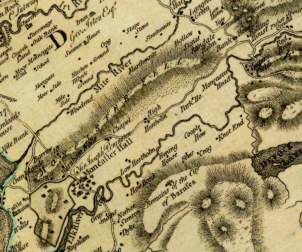 D4SD19NW.jpg "MONCASTER FELL" hill hachuring; a hill or mountain item:- Carlisle Library : Map 2 Image © Carlisle Library |
|
|
|
||
| evidence:- | descriptive text:- Otley 1823 (5th edn 1834) item:- geology |
|
| source data:- | Guide book, A Concise Description of the English Lakes, the
mountains in their vicinity, and the roads by which they may be
visited, with remarks on the mineralogy and geology of the
district, by Jonathan Otley, published by the author, Keswick,
Cumberland now Cumbria, by J Richardson, London, and by Arthur
Foster, Kirkby Lonsdale, Cumbria, 1823; published 1823-49,
latterly as the Descriptive Guide to the English Lakes. goto source goto sourcePage 149:- "A variety of granite with reddish felspar, and which from a deficiency of mica, has sometimes been" goto sourcePage 151:- "called sienite, forms the two inferior mountain ridges, called Irton Fell and Muncaster Fell; ... It contains veins of red hematite and micaceous iron ore. ..." |
|
|
|
||
| evidence:- | outline view:- Linton 1852 placename:- Muncaster Fell |
|
| source data:- | Print, engraving, outline views, Mountains as Seen from the Esk Viaduct, the Eskmeals
Viaduct, and Mountains as Seen from the Viaduct near Drigg, the Irt Viaduct, Whitehaven
and Furness Junction Railway, Cumberland, engraved by W H Lizars, Edinburgh, published
by Whittaker and Co, London, and by R Gibson and Son and by Callander and Dixon, Whitehaven,
Cumberland, 1852.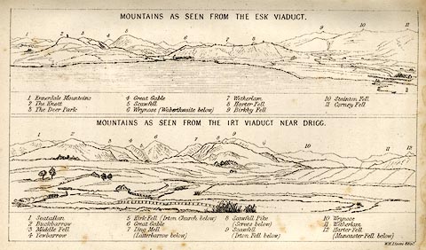 click to enlarge click to enlargeLN1E13.jpg Tipped in opposite p.86 of A Handbook of the Whitehaven and Furness Railway, by John Linton. item:- Armitt Library : A1158.11 Image © see bottom of page |
|
|
|
||
| hearsay:- |
The beacons of west Cumberland were on: Black Combe, Boothill, Moota Hill, Muncaster
Fell, Skiddaw, St Bees Head, and Workington Hill. (Questionable information.) |
|
|
|
||
Lakes Guides menu.