 Old Cumbria Gazetteer
 |
 |
|
| Wood Farm, Lakes | ||
| Wood Farm | ||
| Lowwood Farm | ||
| locality:- | Low Wood | |
| civil parish:- | Lakes (formerly Westmorland) | |
| county:- | Cumbria | |
| locality type:- | buildings | |
| coordinates:- | NY39400156 | |
| 1Km square:- | NY3901 | |
| 10Km square:- | NY30 | |
|
|
||
| evidence:- | old map:- OS County Series (Wmd 26 15) placename:- Low Wood placename:- Wood, Low |
|
| source data:- | Maps, County Series maps of Great Britain, scales 6 and 25
inches to 1 mile, published by the Ordnance Survey, Southampton,
Hampshire, from about 1863 to 1948. |
|
|
|
||
| evidence:- | possibly old map:- Jefferys 1770 (Wmd) placename:- Wood House |
|
| source data:- | Map, 4 sheets, The County of Westmoreland, scale 1 inch to 1
mile, surveyed 1768, and engraved and published by Thomas
Jefferys, London, 1770.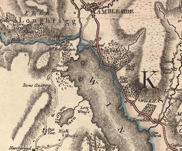 J5NY30SE.jpg "Wood H." circle, labelled in italic lowercase text; settlement, farm, house, or hamlet? item:- National Library of Scotland : EME.s.47 Image © National Library of Scotland |
|
|
|
||
| evidence:- | old text:- Clarke 1787 placename:- Low Wood item:- oak; tree |
|
| source data:- | Guide book, A Survey of the Lakes of Cumberland, Westmorland,
and Lancashire, written and published by James Clarke, Penrith,
Cumberland, and in London etc, 1787; published 1787-93. goto source goto sourcePage 152:- "..." "... There is an oak tree growing at Mr Birkett's of Low-Wood, (see plate X.) which he himself planted, and which is a real curiosity, on account of its beauty, magnitude, and quick growth. A man of the name of Skilbeck had for some years taken notice of the quick growth of this tree; being once at Mr Birkett's sheep-shearing, he found that he could, when sitting upon the ground, exactly fathom it; next year, at the same season, he again" goto sourcePage 153:- "tried the same experiment, but was unable (on account of the tree's growth) to embrace it by three inches. This beautiful "son of the forest" is not of above sixty years standing; its bole is about forty-five feet high, perfectly straight and clear of branch or knot; its head is a verdant hemisphere, whose form is no farther broken than is sufficient to make it picturesque, and its intrinsic value is upwards of fifty pounds. I must remark, that among the singularities of this vicinity, the ground being the property of one person, and the wood (in many places) of another, is worthy our notice: I must likewise add, that the lands here are generally held by the curtesy of England, which I am scarce lawyer enough to understand. If a woman is possessed of any of these lands, and marries, the estate becomes her husband's for life, whether she dies having issue or not, even if he marries again. And if a man dies possessed of such an estate, leaving a widow, the widow holds the whole during her natural life, though she marries again. This was an act of the Queen Elizabeth, as the title deeds set forth, but on what occasion I cannot find." |
|
|
|
||
| evidence:- | old map:- Clarke 1787 map (Windermere N) placename:- Lowwood |
|
| source data:- | Map, A Map of the Northern Part of the Lake Winandermere and its
Environs, scale about 6.5 ins to 1 mile, by James Clarke,
engraved by Samuel John Neele, 352 Strand, published by James
Clarke, Penrith, Cumberland and in London etc, 1787.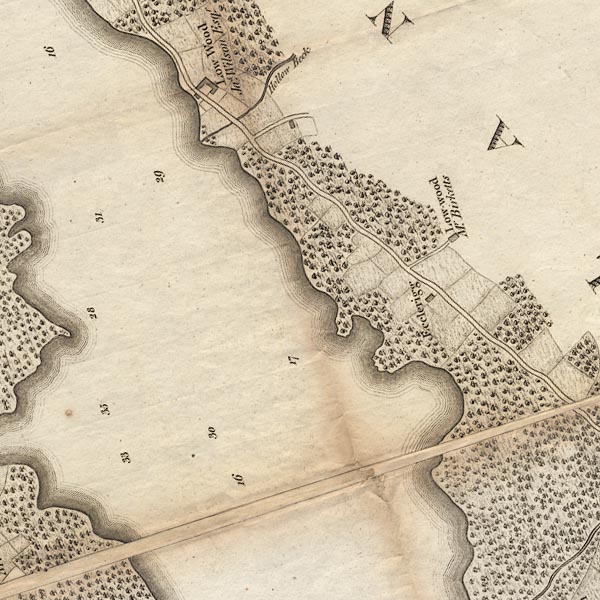 CLANY30V.jpg "Low-wood / Mr. Birketts" item:- private collection : 10.10 Image © see bottom of page |
|
|
|
||
| evidence:- | possibly old map:- Cary 1789 (edn 1805) placename:- Wood House |
|
| source data:- | Map, uncoloured engraving, Westmoreland, scale about 2.5 miles
to 1 inch, by John Cary, London, 1789; edition 1805.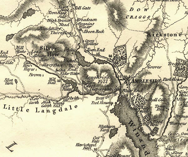 CY24NY30.jpg "Wood Hou." block/s, labelled in italic lowercase; house, or hamlet item:- JandMN : 129 Image © see bottom of page |
|
|
|
||
| evidence:- | database:- Listed Buildings 2010 placename:- Wood Farm |
|
| source data:- | courtesy of English Heritage "WOOD FARMHOUSE / / / LAKES / SOUTH LAKELAND / CUMBRIA / II[star] / 452848 / NY3941601559" |
|
|
|
||
Lakes Guides menu.