 Old Cumbria Gazetteer
 |
 |
|
||||||||||||||||||||||||
| Latrigg, Underskiddaw | ||||||||||||||||||||||||||
| Latrigg | ||||||||||||||||||||||||||
| civil parish:- | Underskiddaw (formerly Cumberland) | |||||||||||||||||||||||||
| county:- | Cumbria | |||||||||||||||||||||||||
| locality type:- | hill | |||||||||||||||||||||||||
| coordinates:- | NY27842465 (etc) | |||||||||||||||||||||||||
| 1Km square:- | NY2724 | |||||||||||||||||||||||||
| 10Km square:- | NY22 | |||||||||||||||||||||||||
| altitude:- | 1203 feet | |||||||||||||||||||||||||
| altitude:- | 367m | |||||||||||||||||||||||||
|
|
||||||||||||||||||||||||||
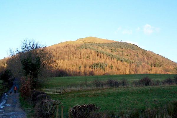 BXT18.jpg (taken 5.12.2012) 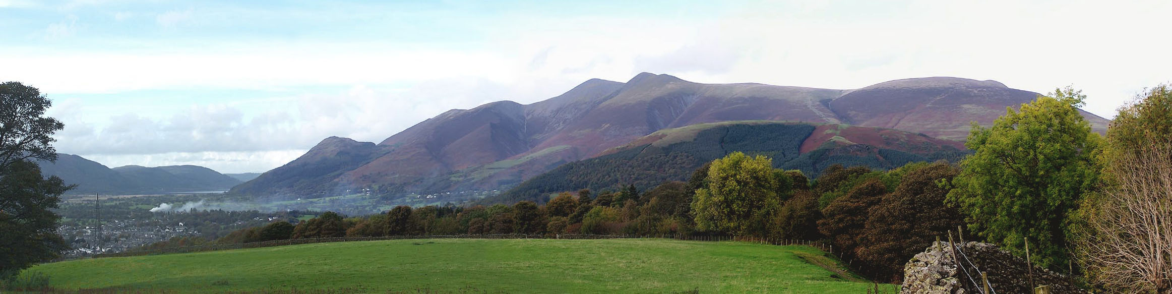 Click to enlarge BMX41.jpg Keswick, Dodd, Skiddaw, Lonscale Fell, Blease Fell and Latrigg, viewed from the south. (taken 23.10.2006) 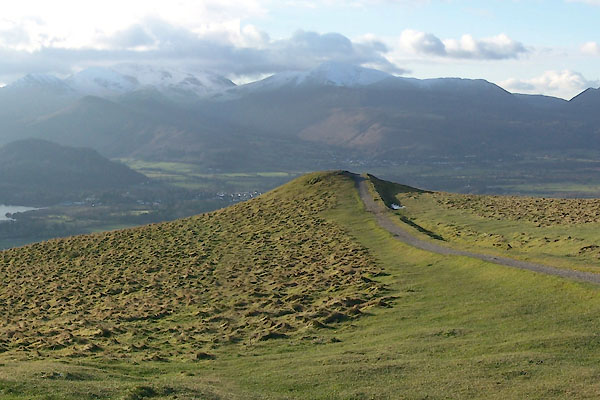 BXT19.jpg West top. (taken 5.12.2012) |
||||||||||||||||||||||||||
|
|
||||||||||||||||||||||||||
| evidence:- | old map:- OS County Series (Cmd 64 3) placename:- Latrigg |
|||||||||||||||||||||||||
| source data:- | Maps, County Series maps of Great Britain, scales 6 and 25
inches to 1 mile, published by the Ordnance Survey, Southampton,
Hampshire, from about 1863 to 1948. |
|||||||||||||||||||||||||
|
|
||||||||||||||||||||||||||
| evidence:- | old map:- Donald 1774 (Cmd) placename:- Latrigg |
|||||||||||||||||||||||||
| source data:- | Map, hand coloured engraving, 3x2 sheets, The County of Cumberland, scale about 1
inch to 1 mile, by Thomas Donald, engraved and published by Joseph Hodskinson, 29
Arundel Street, Strand, London, 1774.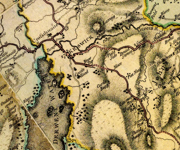 D4NY22SE.jpg "Latrigg" hill hachuring; a hill or mountain item:- Carlisle Library : Map 2 Image © Carlisle Library |
|||||||||||||||||||||||||
|
|
||||||||||||||||||||||||||
| evidence:- | descriptive text:- West 1778 (11th edn 1821) placename:- Latrig placename:- Skiddaw's Cub |
|||||||||||||||||||||||||
| source data:- | Guide book, A Guide to the Lakes, by Thomas West, published by
William Pennington, Kendal, Cumbria once Westmorland, and in
London, 1778 to 1821. goto source goto sourceAddendum; Mr Gray's Journal, 1769 Page 202:- "..." "Oct. 2. I set out at ten for Keswick [from Penrith] ... Passed by the side of Skiddaw and its cub, called Latrigg; ..." goto sourceMrs Radcliffe's Ride over Skiddaw, 1794 Page 304:- "... Passing through bowery lanes, luxurian (sic) with mountain ash, holly, and a variety of beautiful shrubs, to a broad, open common, a road led to the foot of Latrig, (or, as it is called by the country people, Skiddaw's Cub) a large round hill, covered with heath, turf, and browsing sheep. ..." |
|||||||||||||||||||||||||
|
|
||||||||||||||||||||||||||
| evidence:- | old map:- Crosthwaite 1783-94 (Der) placename:- Latrigg |
|||||||||||||||||||||||||
| source data:- | Map, uncoloured engraving, An Accurate Map of the Matchless Lake
of Derwent, ie Derwent Water, scale about 3 inches to 1 mile, by
Peter Crosthwaite, Keswick, Cumberland, 1783, version published
1800.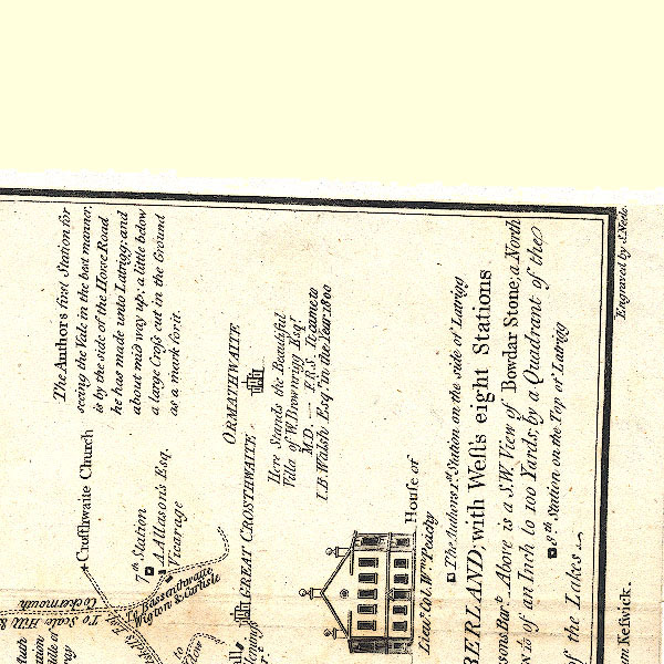 CT2NY22R.jpg "8th. Station on the Top of Latrigg" item:- Armitt Library : 1959.191.3 Image © see bottom of page |
|||||||||||||||||||||||||
|
|
||||||||||||||||||||||||||
| evidence:- | old map:- West 1784 map placename:- Latrig |
|||||||||||||||||||||||||
| source data:- | Map, hand coloured engraving, A Map of the Lakes in Cumberland,
Westmorland and Lancashire, scale about 3.5 miles to 1 inch,
engraved by Paas, 53 Holborn, London, about 1784. Ws02NY22.jpg Shown by a tiny circle of hachuring. item:- Armitt Library : A1221.1 Image © see bottom of page |
|||||||||||||||||||||||||
|
|
||||||||||||||||||||||||||
| evidence:- | old map:- Otley 1818 placename:- Latrigg |
|||||||||||||||||||||||||
| source data:- | Map, uncoloured engraving, The District of the Lakes,
Cumberland, Westmorland, and Lancashire, scale about 4 miles to
1 inch, by Jonathan Otley, 1818, engraved by J and G Menzies,
Edinburgh, Scotland, published by Jonathan Otley, Keswick,
Cumberland, et al, 1833. OT02NY22.jpg item:- JandMN : 48.1 Image © see bottom of page |
|||||||||||||||||||||||||
|
|
||||||||||||||||||||||||||
| evidence:- | outline view:- Otley 1823 (4th edn 1830) placename:- Latrigg |
|||||||||||||||||||||||||
| source data:- | Print, engraving, Outline View of Skiddaw, and Saddleback, as seen on approaching
Keswick from the South, published by Jonathan Otley, Keswick, Cumberland et al, 1830.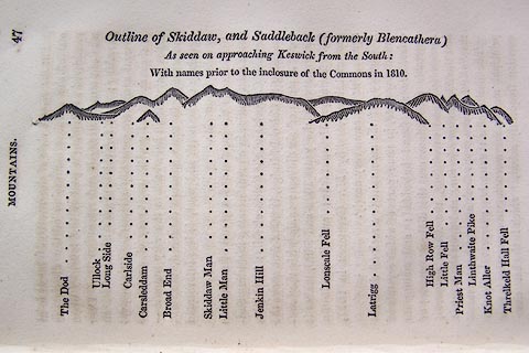 click to enlarge click to enlargeO75E01.jpg p.47 in A Concise Description of the English Lakes, by Jonathan Otley, 4th edition, 1830. "Outline View of Skiddaw, and Saddleback (formerly Blencathera) As seen on approaching Keswick from the South: With names prior to the inclosure of the Commons in 1810." "The Dod / Ullock / Long Side / Carleside / Carsleddam / Broad End / Skiddaw Man / Little Man / Jenkin Hill / Lonscale Fell / Latrigg / High Row Fell / Little Fell / Priest Man / Linthwaite Pike / Knot Aller / Threlkeld Hall Fell" item:- Armitt Library : A1175.2 Image © see bottom of page |
|||||||||||||||||||||||||
|
|
||||||||||||||||||||||||||
| evidence:- | outline view:- Otley 1823 (8th edn 1849) placename:- Latrigg |
|||||||||||||||||||||||||
| source data:- | Engraving, outline view of mountains, Skiddaw, and Saddleback ... as seen on entering
Keswick from the South, drawn by T Binns, engraved by O Jewitt, opposite p.46 of A
Descriptive Guide of the English Lakes, by Jonathan Otley, 8th edition, 1849.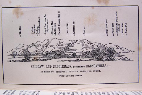 click to enlarge click to enlargeO80E16.jpg item:- Armitt Library : A1180.17 Image © see bottom of page |
|||||||||||||||||||||||||
|
|
||||||||||||||||||||||||||
| evidence:- | outline view:- Otley 1823 (5th edn 1834) |
|||||||||||||||||||||||||
| source data:- | Print, woodcut outline view, Skiddaw and Saddleback, by Jonathan Otley, Keswick, Cumberland,
1830.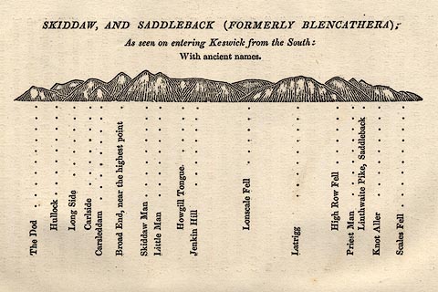 click to enlarge click to enlargeOT2E08.jpg Printed on p.49 of A Concise Description of the English Lakes, by Jonathan Otley, 5th edition, 1834. "SKIDDAW, AND SADDLEBACK (FORMERLY BLENCATHRA): As seen entering Keswick from the South: With ancient names." "The Dod / Hullock / Long Side / Carlside / Carsleddam / Broad End, near the highest point / Skiddaw Man / Little Man / Howgill Tongue / Jenkin Hill / Lonscale Fell / Latrigg / High Row Fell / Priest Man / Linthwaite Pike, Saddleback / Knot Aller / Scales Fell" item:- JandMN : 48.9 Image © see bottom of page |
|||||||||||||||||||||||||
|
|
||||||||||||||||||||||||||
| evidence:- | descriptive text:- Ford 1839 (3rd edn 1843) placename:- Latrigg item:- altitude, Latrigg |
|||||||||||||||||||||||||
| source data:- | Guide book, A Description of Scenery in the Lake District, by
Rev William Ford, published by Charles Thurnam, Carlisle, by W
Edwards, 12 Ave Maria Lane, Charles Tilt, Fleet Street, William
Smith, 113 Fleet Street, London, by Currie and Bowman,
Newcastle, by Bancks and Co, Manchester, by Oliver and Boyd,
Edinburgh, and by Sinclair, Dumfries, 1839. goto source Page 178:- "ELEVATION OF THE MOUNTAINS," "ACCORDING TO DIFFERENT AUTHORITIES."
|
|||||||||||||||||||||||||
|
|
||||||||||||||||||||||||||
| evidence:- | old map:- Ford 1839 map placename:- Latrigg |
|||||||||||||||||||||||||
| source data:- | Map, uncoloured engraving, Map of the Lake District of
Cumberland, Westmoreland and Lancashire, scale about 3.5 miles
to 1 inch, published by Charles Thurnam, Carlisle, and by R
Groombridge, 5 Paternoster Row, London, 3rd edn 1843. FD02NY22.jpg "Latrigg" No hachures. item:- JandMN : 100.1 Image © see bottom of page |
|||||||||||||||||||||||||
|
|
||||||||||||||||||||||||||
| evidence:- | old map:- Garnett 1850s-60s H placename:- Latrigg |
|||||||||||||||||||||||||
| source data:- | Map of the English Lakes, in Cumberland, Westmorland and
Lancashire, scale about 3.5 miles to 1 inch, published by John
Garnett, Windermere, Westmorland, 1850s-60s. GAR2NY22.jpg "Latrigg" hill hachuring item:- JandMN : 82.1 Image © see bottom of page |
|||||||||||||||||||||||||
|
|
||||||||||||||||||||||||||
| evidence:- | old text:- Martineau 1855 item:- altitude, Latrigg |
|||||||||||||||||||||||||
| source data:- | Guide book, A Complete Guide to the English Lakes, by Harriet
Martineau, published by John Garnett, Windermere, Westmorland,
and by Whittaker and Co, London, 1855; published 1855-76. goto source Page 179:- "A TABLE OF THE HEIGHTS OF MOUNTAINS IN THE COUNTIES OF CUMBERLAND, WESTMORLAND, AND LANCASHIRE." "No. : Names of Mountains. : Counties. : Height in Feet above the Sea Level." "26 : Latrigg, Keswick : Cumberland : 1160" |
|||||||||||||||||||||||||
|
|
||||||||||||||||||||||||||
| evidence:- | old text:- Brabant 1902 placename:- Latrigg |
|||||||||||||||||||||||||
| source data:- | Guide book, The Little Guides series, The English Lakes, by F G
Brabant, Oxford, illustrated by Edmund H New, published by
Methuen and Co, 36 Essex Street, Strand, London, 1902. "The visitor will probably chafe at the careful enclosing of the path [on Latrigg]. Some years back the owner attempted to bar the public from access to the mountain. Keswick promptly marched en masse and removed the barriers by force. A law suit followed, and finally the right of access to the summit was conceded, but only along one railed-in pathway. The incident suggests Punch's exaggeration, "Owner up in the Lake District" (Sept. 4, 1886): "Looking at theat there Mounting was you, Sir? Then you're a trespassing! I've orders from the owner to stop any one from looking at his Mounting."" |
|||||||||||||||||||||||||
|
|
||||||||||||||||||||||||||
| evidence:- | outline view:- Black 1856 (23rd edn 1900) placename:- Latrigg |
|||||||||||||||||||||||||
| source data:- | Print, lithograph, Outline Views, Skiddaw and Derwent Water - Mountains as seen at
Lodore Hotel, and Mountains as seen at the Third Gate on Ascending Latrigg on the
Way to Skiddaw, by J Flintoft, Keswick, Cumberland, engraved by R Mason, Edinburgh,
Lothian, about 1900.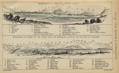 click to enlarge click to enlargeBC08E4.jpg "... Latrigg ..." item:- JandMN : 37.14 Image © see bottom of page |
|||||||||||||||||||||||||
|
|
||||||||||||||||||||||||||
| evidence:- | outline view:- Black 1841 (3rd edn 1846) placename:- Latrigg |
|||||||||||||||||||||||||
| source data:- | Print, engraving, outline view, Mountains as seen at Lowdore Inn, and Mountains as
seen at the Third Gate on Ascending Latrigg on the Way to Skiddaw, by J Flintoft,
Keswick, Cumberland, engraved by R Mason, Edinburgh, Lothian, about 1846.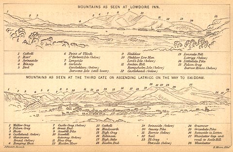 click to enlarge click to enlargeBC02E4.jpg "... Latrigg ..." item:- JandMN : 32.7 Image © see bottom of page |
|||||||||||||||||||||||||
|
|
||||||||||||||||||||||||||
| evidence:- | outline view:- Tattersall 1836 (version 1869) placename:- Latrigg |
|||||||||||||||||||||||||
| source data:- | Print, hand coloured, Derwentwater and Bassenthwaite Lakes, from the road to Watendlath,
Cumberland, drawn by George Tattersall, 1836, engraved by W F Topham, published by
T J Allman, 463 Oxford Street, London, 1869.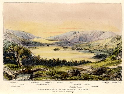 click to enlarge click to enlargeTAT212.jpg Included in The Lakes of England, by W F Topham. printed at bottom:- "DERWENTWATER and BASSENTHWAITE LAKES, / from the road to Watendlath." printed at bottom:- "Swinside. / Lord's Seat. / Barff. / St. Herbert's I. / Bassenthwaite L. / Ramps I. / Vicar's I. / Lord's I. / Skiddaw Dodd. / Castle Hill. / Keswick. / Skiddaw. / Latrigg. / Falcon Crag." item:- Armitt Library : A1067.12 Image © see bottom of page |
|||||||||||||||||||||||||
|
|
||||||||||||||||||||||||||
| evidence:- | outline view:- Tattersall 1836 placename:- Latrigg |
|||||||||||||||||||||||||
| source data:- | Print, engraving, Derwentwater and Bassenthwaite Lakes, from the road to Watenflath,
Cumberland, drawn by George Tattersall, engraved by W F Topham, published by Sherwood
and Co, Paternoster Row, London, about 1836.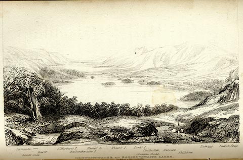 click to enlarge click to enlargeTAT130.jpg The print is captioned with mountain names and acts as an outline view. Tipped in opposite p.77 of The Lakes of England, by George Tattersall. printed at bottom:- "DERWENTWATER and BASSENTHWAITE LAKES, / from the road to Watendlath." printed at bottom left to right:- "Swinside. / Lord's Seat. / Barff. / St. Herbert's I. / Bassenthwaite L. / Ramp's I. / Vicar's I. / Lord's I. / Skiddaw Dodd. / Castle Hill. / Keswick. / Skiddaw. / Latrigg. / Falcon Crag." item:- Armitt Library : A1204.31 Image © see bottom of page |
|||||||||||||||||||||||||
|
|
||||||||||||||||||||||||||
| evidence:- | outline view:- placename:- Latrigg |
|||||||||||||||||||||||||
| source data:- | Print, uncoloured engraving, Derwentwater and Bassenthwaite Lakes from the Road to
Watendlath, Cumberland, published by Sherwood and Co, London, 1836?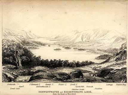 click to enlarge click to enlargePR0370.jpg The view is from just above Ashness Bridge. Objects in the view are identified by a caption at the bottom (unfortunately the print is pale, so some objects are unclear, and the caption seems to be a little misaligned) - Swinside, Lord's Seat, Barff, St. Herbert's I., Bassenthwaite L., Ramp's I., Vicar's I., Lord's I., Skiddaw Dodd, Castle Hill, Keswick, Skiddaw, Latrigg, Falcon Crag. printed at bottom:- "DERWENTWATER and BASSENTHWAITE LAKES. / from the Road to Watendlath." item:- Dove Cottage : 2008.107.370 Image © see bottom of page |
|||||||||||||||||||||||||
|
|
||||||||||||||||||||||||||
| hearsay:- |
In 1814 an agricultural innovator, William Calvert of Windebrowe, drove a track up
Latrigg, ploughed the top, and planted corn. Sadly, it failed. |
|||||||||||||||||||||||||
|
|
||||||||||||||||||||||||||
Lakes Guides menu.